
Terrebonne road gates re-open
June 7, 2020
Lafourche: Government Offices to Open, Garbage Service to run as normal on Monday
June 7, 2020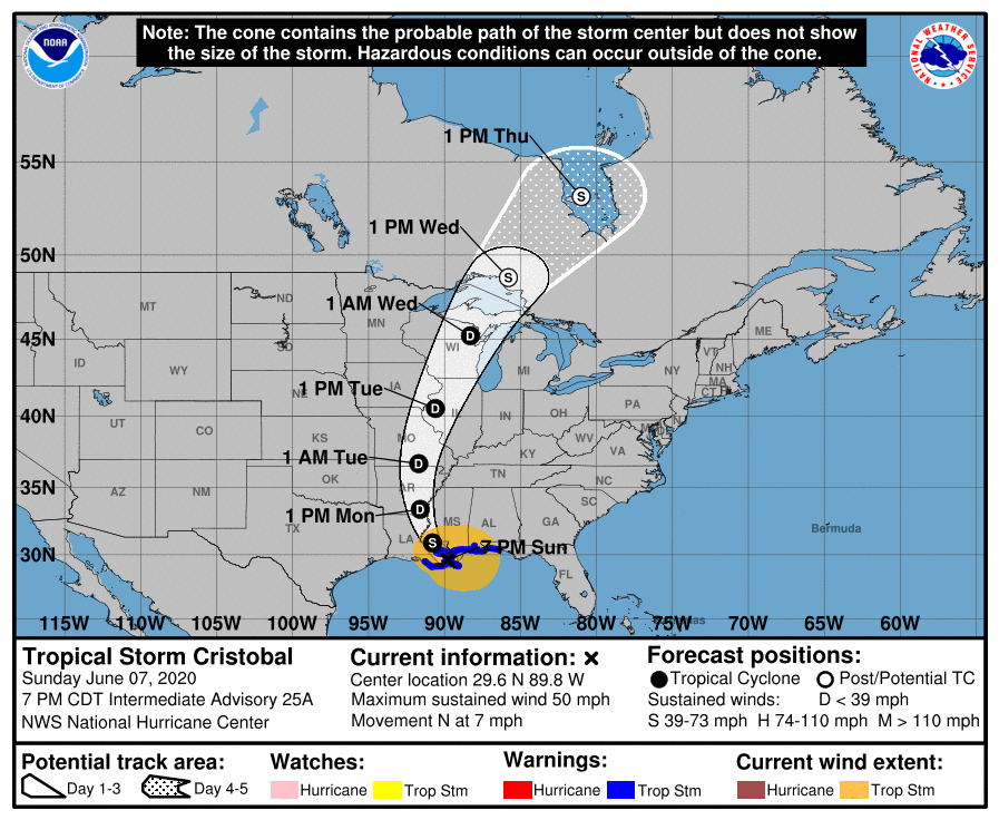
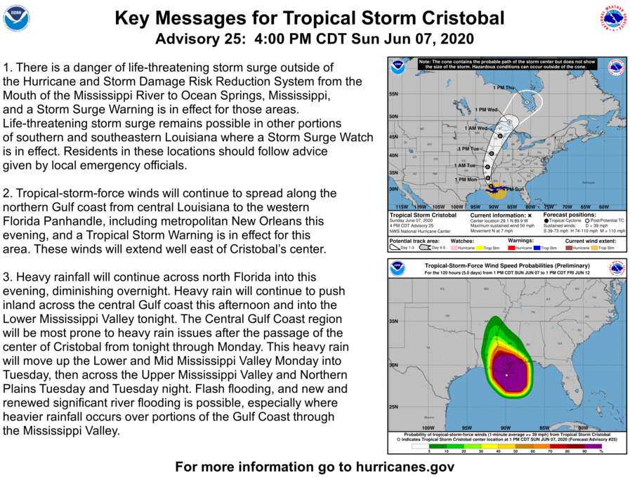
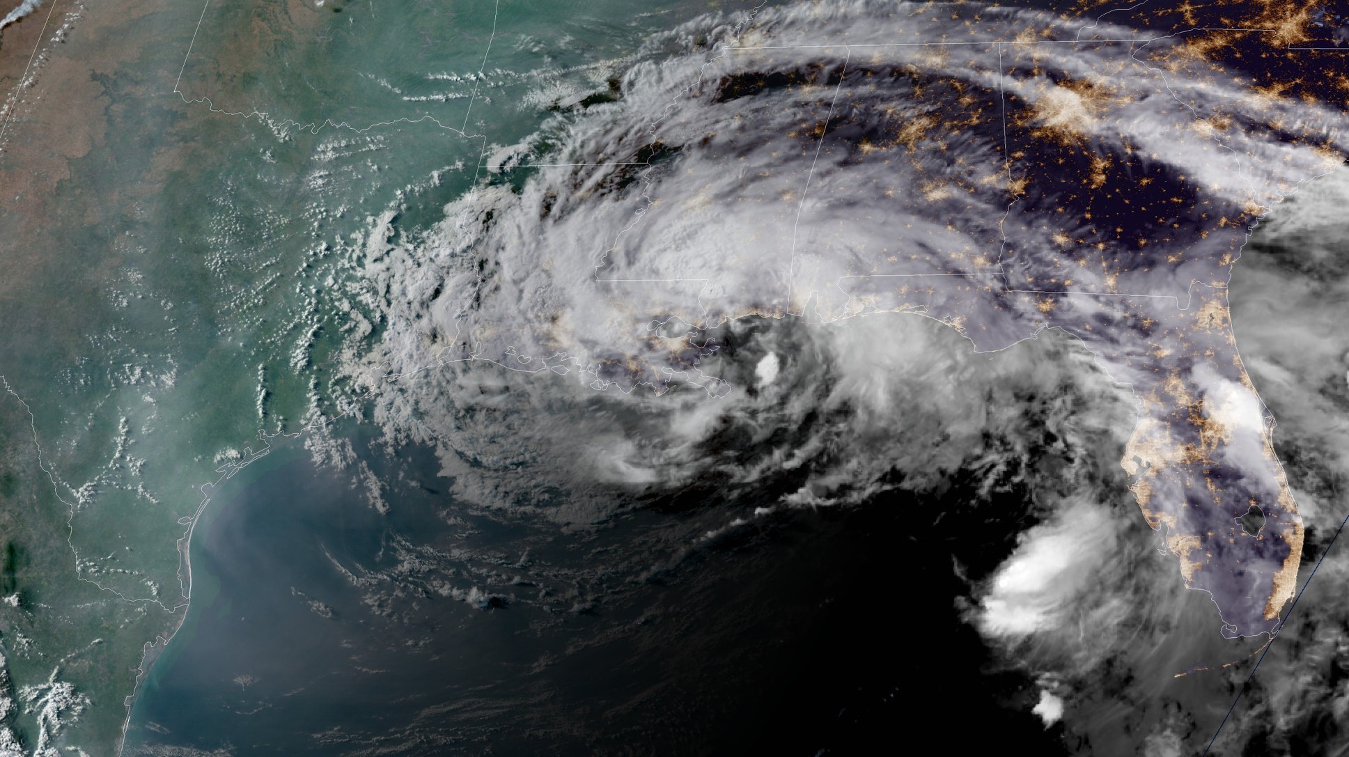
Satellite, radar, and surface data indicate that the center of Tropical Storm Cristobal made landfall at 5 p.m. along the coast of southeast Louisiana between the mouth of the Mississippi River and Grand Isle. Maximum sustained winds were estimated near 50 mph (85 km/h) with a minimum central pressure of 992 mb (29.29 inches).
At 7 p.m. CDT, the center of Tropical Storm Cristobal was located about 35 miles (55 km) south-southeast of the New Orleans, La. It’s moving toward the north near 7 mph (11 km/h). On the forecast track, the center will move inland across southeastern Louisiana through Monday morning, and northward across Arkansas and Missouri Monday afternoon into Tuesday.

A Tropical Storm Warning remains in effect for Morgan City, La., to the Okaloosa/Walton County Florida line, including Lake Pontchartrain and Lake Maurepas. Tropical storm conditions are expected within the warning area along the northern Gulf coast through tonight.
Maximum sustained winds remain near 50 mph (85 km/h) with higher gusts. Tropical-storm-force winds extend outward up to 205 miles (335 km) from the center. A NOAA automated observing station on Dauphin Island, Alabama, recently reported a sustained wind of 45 mph (72 km/h) and a gust to 49 mph (80 km/h), and a Weatherflow site on Ship Island, Mississippi, observed a sustained wind of 37 mph (59 km/h) and a gust to 46 mph (74 km/h). Gradual weakening will begin overnight, and Cristobal is forecast to weaken to a tropical depression on Monday.
Cristobal is expected to produce total rainfall accumulations of 4 to 8 inches across portions of the central Gulf Coast into the Lower Mississippi Valley, with isolated amounts to 12 inches. Rainfall totals of 2 to 4 inches with local amounts to 6 inches are expected across portions of the eastern Gulf Coast, along with the Mid to Upper Mississippi Valley and Northern Plains near and in advance of Cristobal. This rainfall will likely lead to flash flooding and widespread flooding on smaller streams across portions of the central Gulf Coast into the Lower Mississippi Valley. New and renewed significant river flooding is possible along the central Gulf Coast and into the Mississippi Valley.

A few tornadoes are possible tonight across eastern Louisiana, southern Mississippi, southern Alabama, and northern Florida.
The next complete advisory will be issued by NHC at 10 p.m. CDT.

