
Cristobal slows as it nears the coast, currently 30 miles from Grand Isle
June 7, 2020
Dove orders closure of EOC on Sunday evening as threats from Cristobal cease
June 7, 2020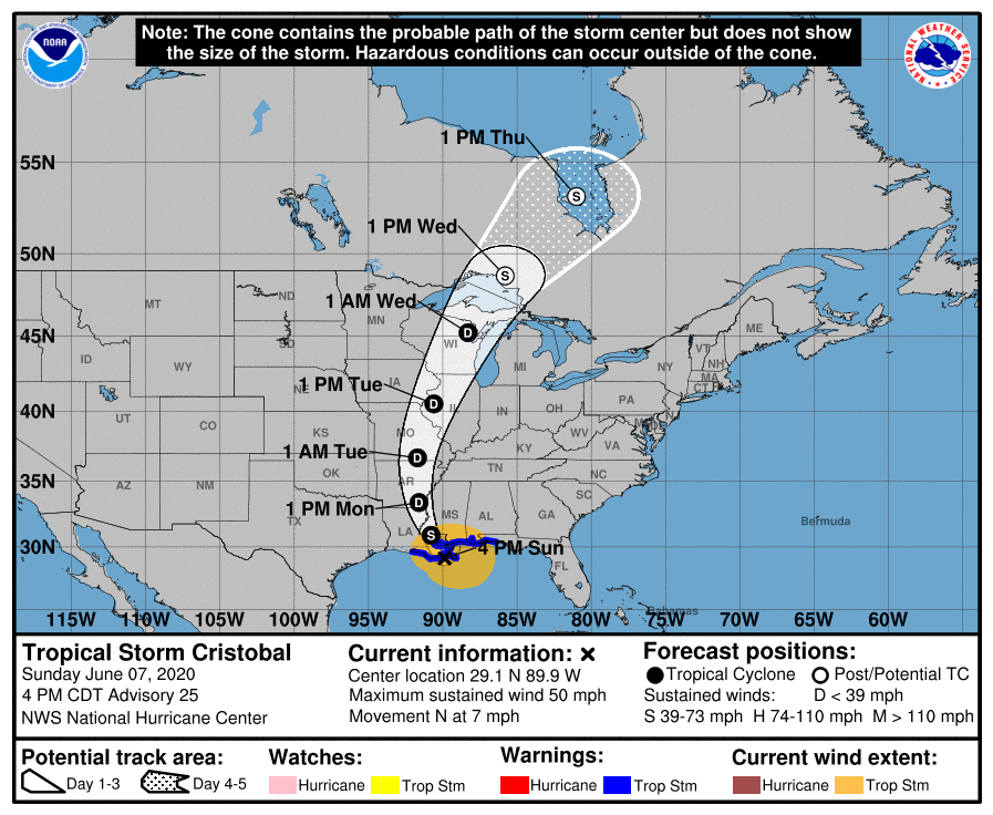
Tropical Storm Cristobal has increased its speed, now moving at 7mph. The storm took an easterly jog and is now forecast to make landfall east of Port Fourchon. The heaviest rainfall is currently along the Mississippi Gulf Coast.

WWL-TV Meteorologist Payton Malone sent the following to GLPC/Port Fourchon as of 3:45 p.m.:
“Cristobal wobbled to the east after slowing down, but is finally drifting back to the north now. It is still expected to make landfall this afternoon, but now to the east of Port Fourchon. Winds will likely stay out of the north this afternoon for Port Fourchon as the storm lifts to the north. The winds could continue to gust over 45 mph. Tides will remain elevated as the storm lifts away and winds return back out of the south by Monday with banding still possible, but more surge is not expected. Tides will remain elevated through tonight and Monday.”
From NHC:
At 400 PM CDT (2100 UTC), the center of Tropical Storm Cristobal was located near latitude 29.1 North, longitude 89.9 West. Cristobal is moving toward the north near 7 mph (11 km/h), and this general motion is expected to continue this afternoon, followed by a gradual turn toward the north-northwest later this evening and tonight. On the forecast track, the center of Cristobal will approach the
northern Gulf of Mexico coast this afternoon, then move inland across southeastern Louisiana this afternoon through Monday morning, and northward across Arkansas and Missouri Monday afternoon into Tuesday.
Data from NOAA Doppler weather radars and offshore oil platforms indicate that maximum sustained winds remain 50 mph (85 km/h) with higher gusts. Little change in strength is forecast before landfall.
Gradual weakening will begin once Cristobal moves inland.
Tropical-storm-force winds extend outward up to 205 miles (335 km) from the center. During the past couple of hours, an oil rig located about 80 miles south of Mobile, Alabama, measured a sustained wind of 51 mph (82 km/h) and a gust to 64 mph (103 km/h) at an elevation of 123 ft. A NOAA automated observing station on Dauphin Island, Alabama, recently reported a sustained wind of 42
mph (68 km/h) and a gust to 48 mph (77 km/h), and a Weatherflow site on Ship Island, Mississippi, observed a sustained wind of 41 mph (66 km/h) and a gust to 51 mph (77 km/h). The estimated minimum central pressure based on nearby surface observations is 993 mb (29.32 inches).

