Sally expected to make landfall as a Category 2 storm; Area now under hurricane watch
September 13, 2020
Elmer’s Island to Close at Noon
September 13, 2020
As Tropical Storm Sally rapidly develops, Port Fourchon is moving Storm Phase 3, which is Recommended Evacuation. This means that tropical force winds are expected to be in Port Fourchon within 50 hours or less. We ask that port tenants and users continue to be alert for updates and prepared for things to change or progress quickly.
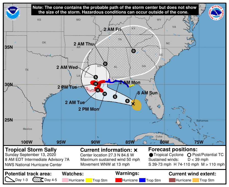
Tropical Storm Sally has shifted westward and is now forecast to make landfall somewhere near Plaquemines on Tuesday as a Category 1 or 2 hurricane, although there is still uncertainty in forecast track and intensity. Coastal flooding, heavy rain, and strong/damaging wind chances have all increased considerably overnight.

Please begin securing or moving equipment out of port and determine the intentions and/or special needs of all vessels and personnel at your facilities in the port.
Non-essential personnel should evacuate the port. Please secure hazards and clear non-essential equipment from facility grounds, prepare office areas to minimize water intrusion damage, secure buildings with storm shutters or plywood over windows and doors, secure fuel tanks and storage areas, and remove all small craft that can be hauled or trailered from port facilities and waterways, well away from the effects of possible storm surge and high winds. Remember, all vessels remaining in port must be manned. No new mooring dolphin rentals will be accepted once Phase III has been activated; any unleased dolphins will be considered first come, first served until the storm is over.
Port Fourchon Harbor Police will be monitoring the condition of the roadway, and the Port Commission will send out updates as they become available.

Please review your facility’s hurricane plan, be thoughtful of stockpiling any loose material or excess items that could fly away or be damaged if Port Fourchon is affected by a storm, and make sure the Port Commission has your facility’s updated contact information so that you can receive timely storm-related information.
POSSIBLE IMPACTS IN THE PORT FOURCHON AREA:
- RAINFALL: Rainfall totals of 6 to 12 inches are forecast through Tuesday, with locally higher amounts possible. Slow movement of this system could create significant rainfall and associated flooding threats.
- TIDES/STORM SURGE: Storm surge of 4-7 feet possible, depending on storm track and intensity. Storm surge could begin as early as Monday morning.
- WINDS: Increased probability of sustained tropical force winds and tropical storm force wind gusts across much of southeast Louisiana. Potential for hurricane force gusts across coastal LA. Winds expected at the coast late today into early Monday.
- ROADWAYS: No closures at this time.
WARNINGS, WATCHES, & ADVISORIES (Updated 9/13/2020 @ 6:00 AM):

- Hurricane Watch in effect for Lafourche Parish.
- Storm Surge Warning in effect for coastal LA, including the Port Fourchon area.
- Flash Flood Watch in effect for Lafourche Parish.
EMERGENCY STORM HARBOR MARINA:
GLPC has opened the Emergency Storm Harbor Marina to commercial fishing vessels seeking safe harbor within the South Lafourche Levee System. Utilization of this marina will be on a first come, first served basis. Harbor Police will be on scene to monitor marina activity.
Visit this link to view GLPC Ordinance No. 74 regarding Storm Harbor Marina use:

http://portfourchon.com/wp-content/uploads/Ordinance74.pdf
NOTIFICATIONS AND WEATHER INFORMATION:
If you have signed up to any of our public information or emergency notification lists, e-mails, and/or social media, messages will be sent out regularly during a weather event with up-to-date information. If you would like to sign up for any notifications from the Port Commission, visit our NOTIFY ME page.

Visit the Port Commission’s WEATHER & STORM INFO webpage for links to current storm information, helpful storm prep information and resources, and contact updating forms.
We will continue to evaluate the threat this weather poses and keep you updated with any developing weather-related issues.

