
Lafourche booking log – June 18 and 19
June 20, 2017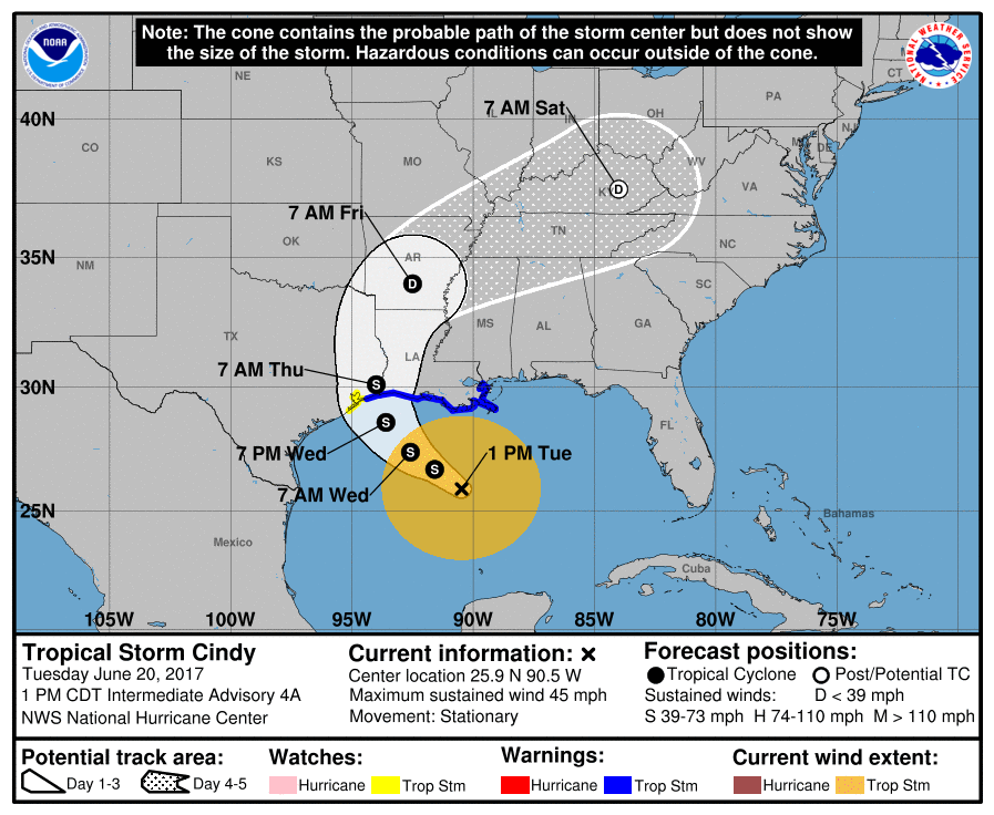
Lafourche, Terrebonne declare states of emergency due to Cindy
June 20, 2017There is officially a tropical storm in the Gulf of Mexico.
After 24-48 hours of tracking a tropical cyclone in the Gulf, the National Hurricane Center has upgraded the area to Tropical Storm Cindy in its 1 p.m. weather advisory.

At the 1 p.m. advisory on Tuesday afternoon, the storm is located at 25.9 degrees North, 90.5 degrees West and it has maximum sustained winds of 45 mph.
Cindy’s movement is currently stationary, which is a change from earlier motion, which was to the northwest.
Forecast tracks call for landfall around 11 p.m. on Wednesday night – somewhere near the Louisiana/Texas border. But that track was issued before the current slowdown, so the timing may now be altered in a future advisory, according to the National Hurricane Center.

A landfall in that area would make Cindy a significant rain event for most of Southeast Louisiana, as almost all of the storm’s rain field is located to the east of the center.
Forecasters expect rains and winds locally to significantly increase tonight and into tomorrow morning as Cindy gets closer to the shore. As of 1 p.m. today, some rain bands have already started to come onshore.
A tropical storm warning is still in effect for both Lafourche and Terrebonne, which means that tropical storm force winds (39 mph or greater) are expected in the next 24 hours.

Because of strong wind sheer in the Gulf of Mexico, the storm is not expected to significantly strengthen – if at all – before making landfall.

