LPSO to host Rape Aggression Defense course in Raceland
August 15, 2021
National Guard Offering Free COVID Vaccines Daily at Nicholls
August 15, 2021No rest for meteorologists this time of year… things can shift drastically from one update to the next. Today’s 10am update shows new changes to the storms we have been monitoring.
Fred is once again a Tropical Storm
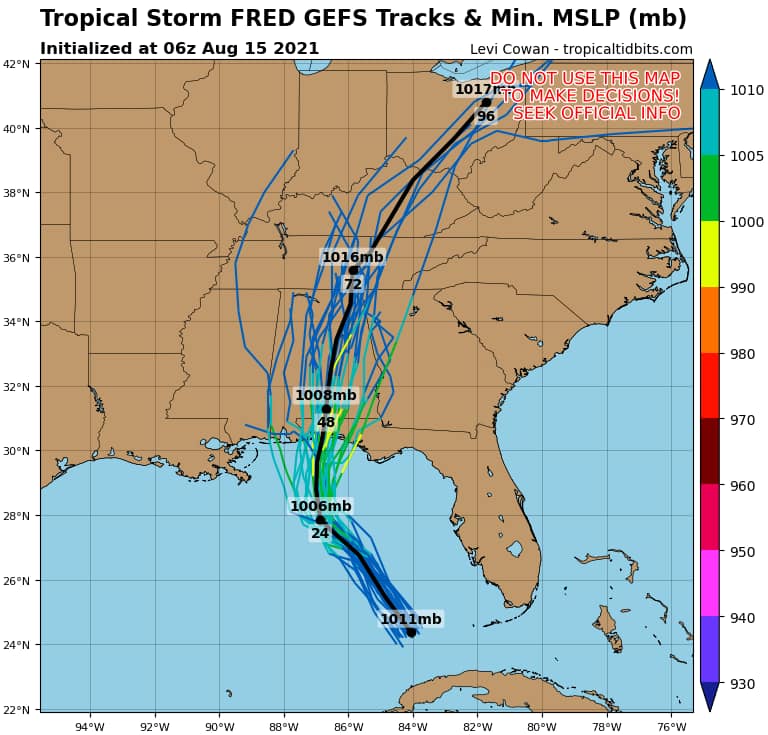
At 11 a.m. EDT, the center of Tropical Storm Fred was located over the eastern Gulf of Mexico about 335 miles (540 km) south-southeast of Pensacola, Florida. It’s moving toward the north-northwest near 12 mph (19 km/h), and this motion should continue through tonight. A turn toward the north is expected on Monday. On the forecast track, the center of Fred should move across the eastern and northern Gulf of Mexico through Monday, then make landfall in the western Florida Panhandle Monday afternoon or Monday night.
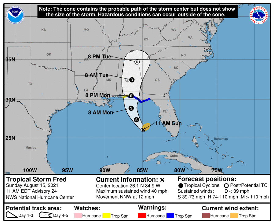
Reports from an Air Force Reserve Hurricane Hunter aircraft indicate that maximum sustained winds are near 40 mph (65 km/h) with higher gusts. Tropical-storm-force winds extend outward up to 80 miles (130 km) from the center. The minimum central pressure reported by the Hurricane Hunter aircraft is 1008 mb (29.77 inches). Gradual strengthening is expected until landfall, while Fred is expected to weaken quickly after landfall.
The combination of a dangerous storm surge and the tide will cause normally dry areas near the coast to be flooded by rising waters moving inland from the shoreline. The water could reach the following heights above ground somewhere in the indicated areas if the peak surge occurs at the time of high tide:
– Indian Pass to Steinhatchee River…2-4 ft
– AL/FL state line to Indian Pass including Pensacola Bay, Choctawhatchee Bay and Saint Andrew Bay… 1-3 ft
– Steinhatchee River to Chassahowitzka, FL…1-3 ft
Fred is expected to produce the following rainfall amounts:
* Through Monday…
– Florida Keys and southern Florida… 3 to 5 inches of rain is anticipated.
* Through Tuesday…
– The Florida Big Bend and Panhandle… 4 to 8 inches with isolated maximum storm totals of 12 inches are expected.
– South-Central and Southeast Alabama through Georgia and the Western Carolinas… 3 to 6 inches with isolated maximum storm totals of 9 inches are expected due to the combination of Fred and a preceding frontal boundary.
– Heavy rainfall across portions of Florida, southern Alabama, portions of Georgia, and the western Carolinas could lead to areal, urban, small stream and river flooding impacts.
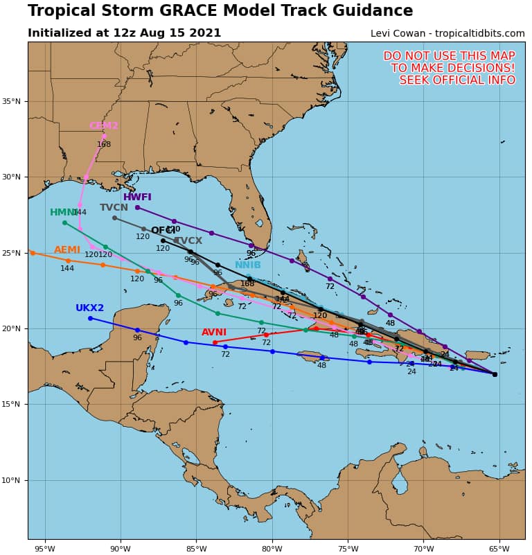
Tropical Storm Grace changes her path
At 11 a.m. AST, the center of Tropical Storm Grace was located about 85 miles (135 km) south of San Juan, Puerto Rico, and about 270 miles (435 km) east-southeast of Santo Domingo, Dominican Republic. It’s moving toward the west-northwest near 16 mph (26 km/h). A continued west-northwestward motion at a slower forward speed is expected over the next few days. On the forecast track, the center of Grace will move over Hispaniola on Monday, near or over eastern Cuba on Tuesday, and near or over west-central Cuba on Wednesday.
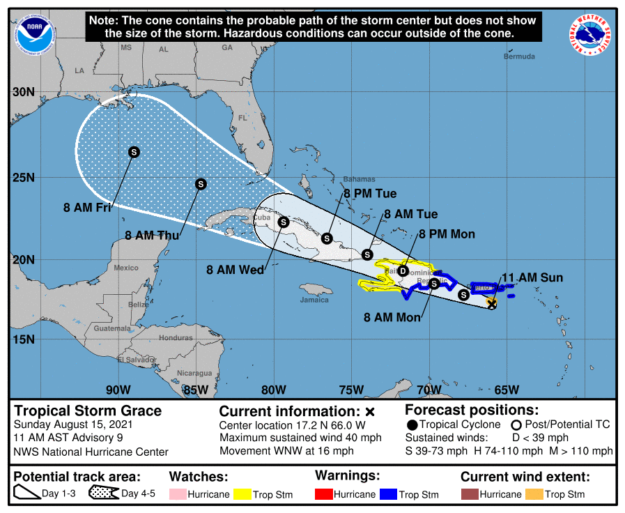
Maximum sustained winds are near 40 mph (65 km/h) with higher gusts. Tropical-storm-force winds extend outward up to 35 miles (55 km) from the center. The estimated minimum central pressure is 1010 mb (29.83 inches). Some strengthening is forecast until Grace moves over Hispaniola on Monday. Weakening is forecast while the system crosses Hispaniola Monday and Monday night. Some restrengthening could occur if the center moves back over water on Tuesday.