
Two students test positive for COVID-19 at local Catholic schools
August 20, 2020
US Senate candidate speaks to voters in Houma
August 20, 2020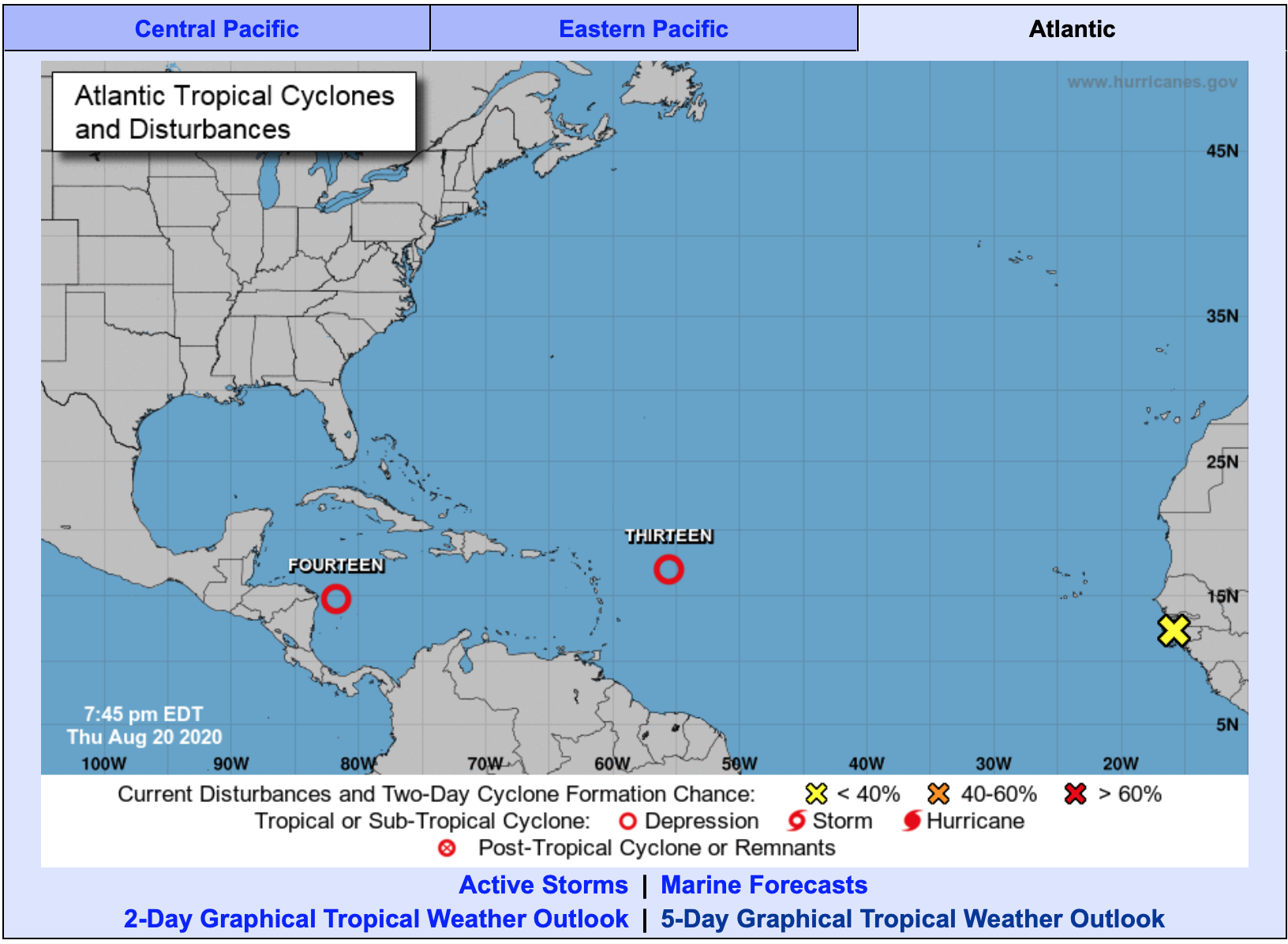
As the tropics keep us on our toes, all eyes continue to monitor the weather carefully.

Tropical Depression 14
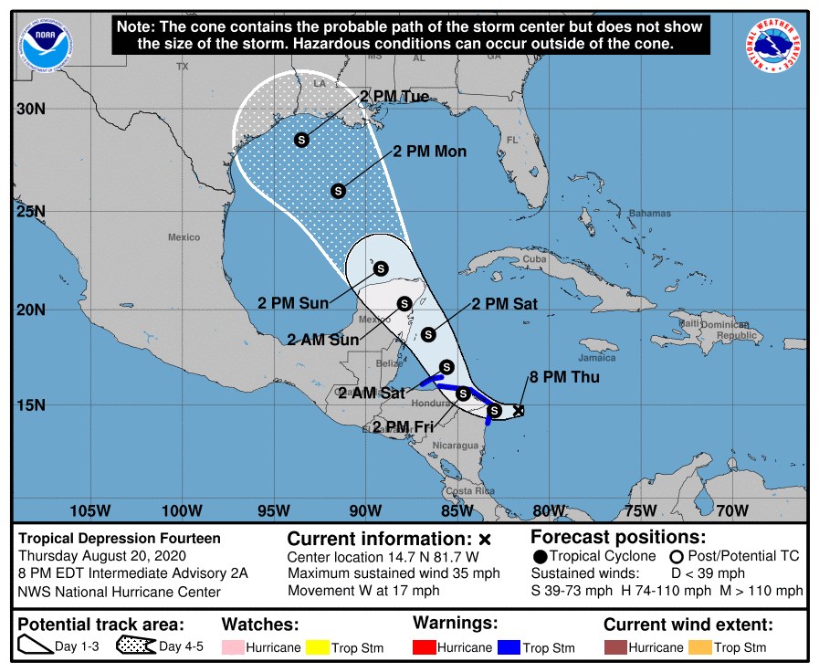
Tropical Depression 14 is showing signs of getting better organized, and is expected to become a Tropical Storm on Friday.
At 5 p.m., EDT, the center of Tropical Depression Fourteen was located over the western Caribbean Sea about 100 miles (165 km) east-southeast of Cabo Gracios A Dios on the Nicaragua / Honduras border. It’s moving toward the west near 17 mph (29 km/h), and this general motion is expected to continue through tonight. On the forecast track, the center of the system will move near or over extreme northern Nicaragua and northeastern Honduras, including the Bay Islands, on Friday, approach the east coast of the Yucatan Peninsula of Mexico on Saturday, cross the Yucatan Peninsula on Saturday night and then move into the south-central Gulf of Mexico on Sunday.
Maximum sustained winds are near 35 mph (55 km/h) with higher gusts. Strengthening is forecast to take place during the next couple of days, and the depression is expected to become a tropical storm on Friday. The system could be near or at hurricane strength when it reaches the Yucatan Peninsula of Mexico late Saturday.

A Tropical Storm Warning continues for…
* Honduras/Nicaragua border westward to Punta Castilla Honduras
* Bay Islands of Honduras
* Puerto Cabezas Nicaragua northward to the Honduras/Nicaragua border
Tropical storm conditions are expected to first reach the coast within the warning area by tonight, making outside preparations difficult or dangerous. These conditions will spread westward along the coast of Honduras within the warning area on Friday.
Additional watches or warnings, including for the Yucatan Peninsula of Mexico, may be required later this evening or tonight.
Tropical Depression 13
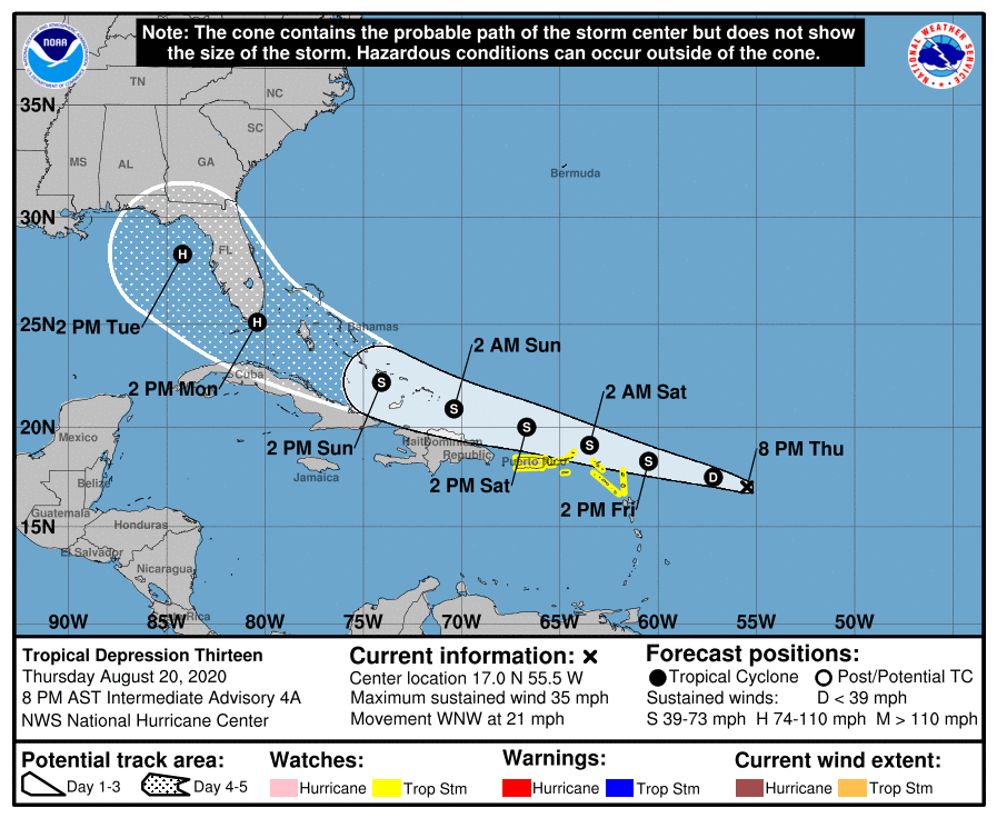
Initial reports from a NOAA Hurricane Hunter aircraft indicate the depression is not well organized.
At 8 p.m. AST, the center of Tropical Depression Thirteen was located over the Atlantic Ocean about 505 miles (815 km) east of the northern Leeward Islands. It’s moving toward the west-northwest near 21 mph (33 km/h), and this motion is expected to continue for the next few days. On the forecast track, the depression is expected to move near or north of the northern Leeward Islands by late Friday, near or north of the Virgin Islands and Puerto Rico on Saturday, and near or north of Hispaniola on Saturday night.

Maximum sustained winds are near 35 mph (55 km/h) with higher gusts. Gradual strengthening is forecast to occur, and the depression is expected to become a tropical storm on Friday.
A Tropical Storm Watch continues for…
* Puerto Rico, Vieques and Culebra
* U.S. Virgin Islands
* British Virgin Islands
* Saba and St. Eustatius
* St. Maarten
* St. Martin and St. Barthelemy
* Antigua, Barbuda, St. Kitts, Nevis, and Anguilla
Tropical storm conditions are possible within the watch area late Friday and Saturday. Interests elsewhere in the northern Leeward Islands, the Virgin Islands, and Puerto Rico should monitor the progress of this system, as additional tropical storm watches or warnings will be required for portions of those areas later today. For storm information specific to your area, please monitor products issued by your national meteorological service.
The depression is also expected to produce 1 to 3 inches of rain with isolated maximum totals of 5 inches over the northern Leeward Islands, and maximum totals of 3 to 6 inches over Puerto Rico and the Virgin Islands through Sunday.
The details of the long-range track and intensity forecasts are more uncertain than usual since the system could move over portion of the Greater Antilles this weekend. However, this system could bring some storm surge, rainfall and wind impacts to portions of Hispaniola, Cuba, the Bahamas, and Florida this weekend and early next week. Interests there should monitor this system’s progress and updates to the forecast over the next few days.

