
TPSO finds dead body; authorities investigating incident
July 9, 2019
Lafourche Booking Log – July 8, 2019
July 9, 2019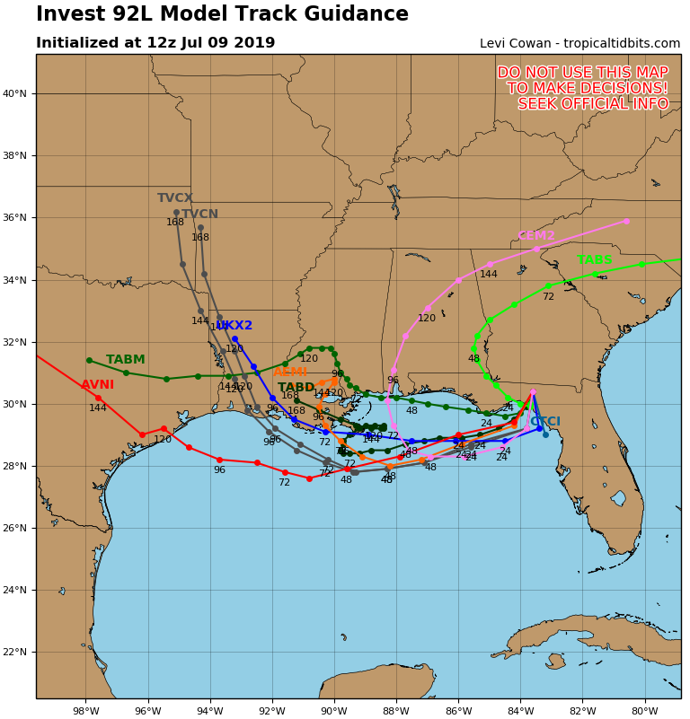
Weather experts continue to warn that Tropical Storm Barry is likely to form in the Gulf of Mexico in the next 36-48 hours.
But while computer model guidance remains all over the map on his potential landfall, the storm is not expected to be much more than a rainmaker.

The National Weather Service developed Invest 92 yesterday afternoon to officially track a frontal boundary dipping into the Gulf of Mexico – an area that’s expected to tropically develop once it hits the warm waters.
Invest 92 is located over the panhandle of Florida, as of Tuesday morning. Later today, it will sink into the Gulf of Mexico – a southward trek that will continue about 150-200 miles offshore before the area reverses course and heads back toward land.
What happens after that is the mystery.

Most models take the storm in a westward direction at first before making a sharp turn toward the north.
The timing of that turn varies, which is why some models predict a Southeastern Louisiana landfall, while others vary – including some which predict the storm to hit Alabama.
Model intensity forecasts call for Barry to be just a minimal tropical storm. His biggest threats will be potential flooding rains. The storm is expected to be a slow mover, so the back-end of our week could be soggy.

See HoumaTimes.com for further updates.

