
Port Fourchon remains in Storm Watch phase
September 20, 2020
5 a.m. update: LA 1 remains closed
September 21, 2020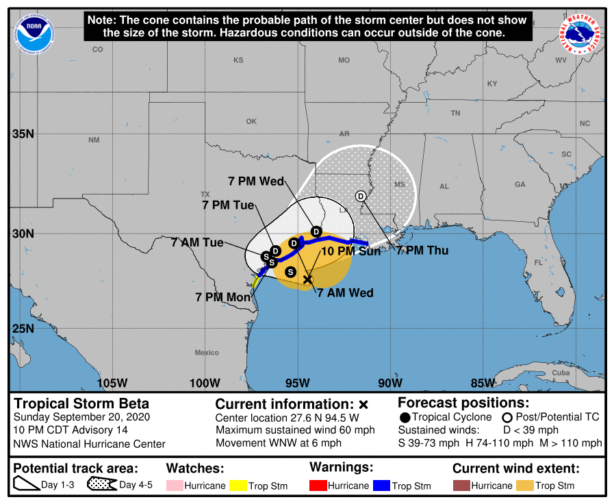
The new forecast path for Beta shows it weakening to a depression by late Tuesday. Beta is moving slowly west-northwest at 6 mph. Winds remain the same at 60 mph, but the storm is looking disorganized. Beta has been struggling due to dry air wrapping around from the western side. Impacts for southeast Louisiana will be rainfall, possibly 3-5 inches with isolated 7 inches or higher.
At 1000 PM CDT (0300 UTC), the center of Tropical Storm Beta was located by an Air Force Reserve reconnaissance aircraft near latitude 27.6 North, longitude 94.5 West. Beta is moving toward the west-northwest near 6 mph (9 km/h), and this general motion is forecast to continue for the next day or so. A decrease in forward speed and a sharp turn to the north and northeast is expected Monday night and Tuesday. On the forecast track, the center of Beta will continue to move toward the central coast of Texas and will likely move inland by Monday night, and remain close to the coast of southeastern Texas on Tuesday.

Maximum sustained winds are near 60 mph (95 km/h) with higher gusts. Little change in strength is forecast before Beta reaches the Texas coast. Weakening is anticipated once Beta moves inland.
Tropical-storm-force winds extend outward up to 195 miles (315 km) from the center. The latest minimum central pressure estimated from data from an Air Force Reserve reconnaissance aircraft is 995 mb (29.39
inches).

