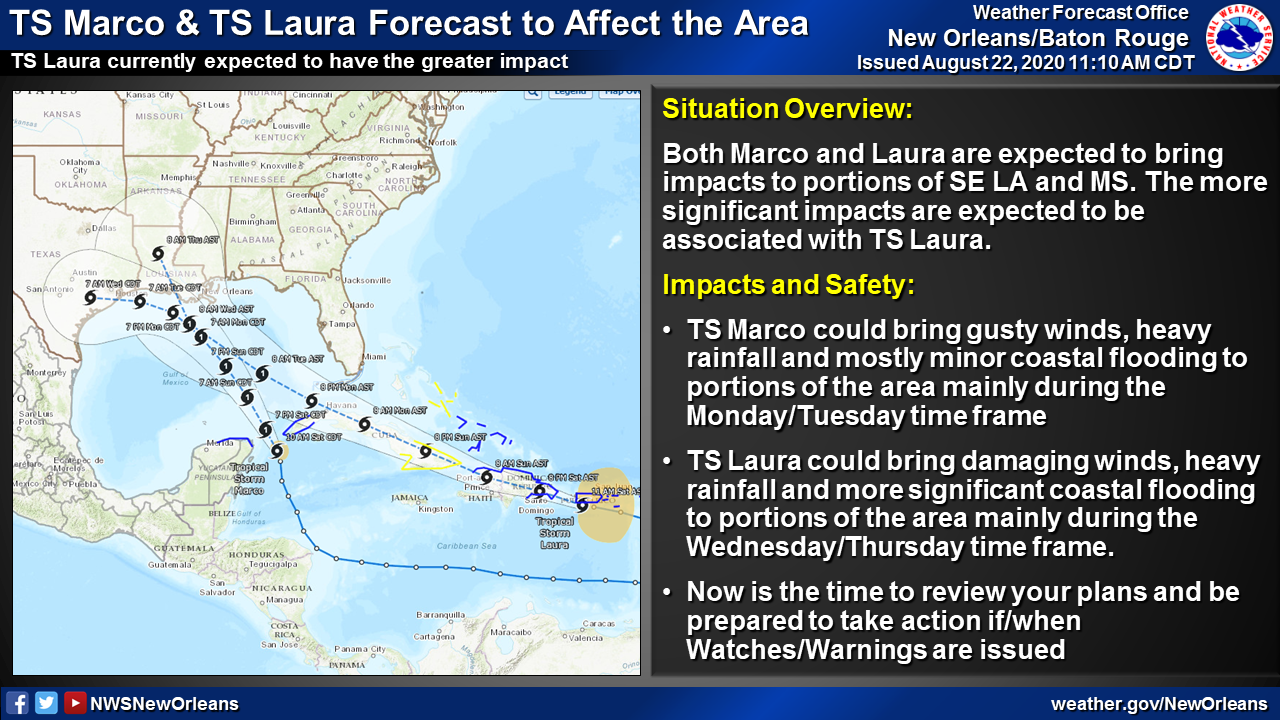
Forecast map shows storms arriving one after the next
August 22, 2020
Terrebonne Parish Council meetings canceled this week
August 22, 2020
Port Fourchon is moving to Storm Phase II, which is Voluntary Evacuation. This means that tropical force winds are expected to be in Port Fourchon within 72 hours. The Port Commission is keeping an eye on the development of both Tropical Storm Laura and Tropical Storm Marco. Due to the fluidity of forecast tracks during this highly unusual weather event, we ask that port tenants and users be alert for updates and prepared for things to change or progress quickly.
Coastal flooding, heavy rain, and strong/damaging winds will all be possible depending on the tracks and intensities of the two systems. Marco could bring impacts to the area as early as Monday; Laura’s more significant impacts are currently expected during the Wednesday/Thursday time frame.

Please begin securing or moving equipment out of port and determine the intentions and/or special needs of all vessels and personnel at your facilities in the port.
Please review your facility’s hurricane plan, be thoughtful of stockpiling any loose material or excess items that could fly away or be damaged if Port Fourchon is affected by a storm, and make sure the Port Commission has your facility’s updated contact information so that you can receive timely storm-related information.
POSSIBLE IMPACTS IN THE PORT FOURCHON AREA:

- There is higher than normal uncertainty in these forecasts due to potential interactions between the two systems. Expect significant changes to forecast impacts.
- RAINFALL: Potential for heavy rainfall, especially Monday through Thursday next week. Rainfall totals of 2-6 inches are forecast through Thursday, with locally higher amounts possible.
- TIDES: Elevated tides could affect portions of the area depending on the eventual tracks and intensity of the two systems.
- WINDS: Tropical storm force winds expected sometime between Sunday evening and Monday from TS Marco; TS Laura could bring strong, damaging winds Wednesday and Thursday.
- ROADWAYS: Roads are currently open to vehicular traffic, but coastal flooding is a concern as always on Hwy 1 between Leon Theriot Flood Gates in Golden Meadow and Elevated Hwy 1 in Leeville. NOTE: LA DOTD’s road work on this stretch of LA 1 is being halted in advance of these weather systems, and all equipment and road construction supplies are being moved out of the area so that traffic routes are clear for any upcoming weather impacts.
EMERGENCY STORM HARBOR MARINA:
GLPC has opened the Emergency Storm Harbor Marina to commercial fishing vessels seeking safe harbor within the South Lafourche Levee System. Utilization of this marina will be on a first come, first served basis. Harbor Police will be on scene to monitor marina activity.
Visit this link to view GLPC Ordinance No. 74 regarding Storm Harbor Marina use:
http://portfourchon.com/wp-content/uploads/Ordinance74.pdf
NOTIFICATIONS AND WEATHER INFORMATION:
If you have signed up to any of our public information or emergency notification lists, e-mails, and/or social media, messages will be sent out regularly during a weather event with up-to-date information. If you would like to sign up for any notifications from the Port Commission, visit our NOTIFY ME page.

Visit the Port Commission’s WEATHER & STORM INFO webpage for links to current storm information, helpful storm prep information and resources, and contact updating forms.
We will continue to evaluate the threat this weather poses and keep you updated with any developing weather-related issues.
