
Gilbert Raymond Parker Jr.
July 26, 2020
Dolly Carrier
July 27, 2020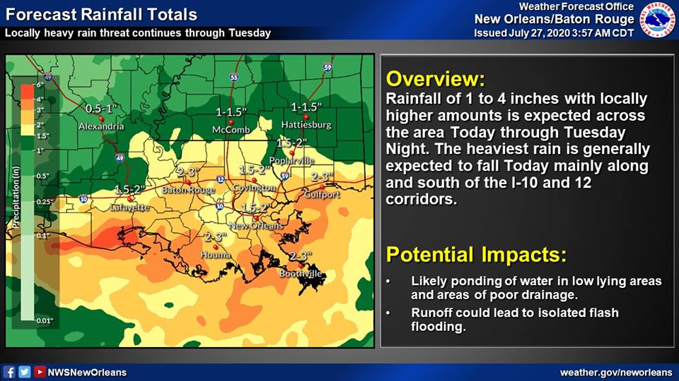
From the National Weather Service:
Here is an update concerning the heavy rain threat today through
Tuesday.
Changes from the previous update:
The threat of heavy rainfall/flash flooding for today has increased with the Slight Risk now covering all over
coastal MS.
No change in the risk for Tuesday
No change in the tropics, the tropical wave in the Atlantic still has a high chance of developing into a depression or storm in the next 2 to 5 days.
Overview:
WHAT:
MARGINAL RISK
to
SLIGHT RISK
of Heavy Rain
WHEN:
Today through Tuesday
WHERE:
Slight Risk for excessive rainfall mainly along and south of the I-10 and 12 corridors. This includes most of coastal MS and the New Orleans metro. A Marginal Risk remains in place for the rest of the area today. There is a Marginal Risk for excessive rainfall
for all of the outlook area Tuesday.
CONFIDENCE:
Confidence is high there will be widespread showers with scattered thunderstorms
across the area beginning early today. These will have the capability to produce heavy rainfall. The most likely location for heavy rain will be along and southeast of a line from near Houma, LA to Poplarville, MS. Confidence is also high that numerous to
widespread showers and embedded thunderstorms will occur Tuesday, however we are less confident in exactly where the greatest threat will be.
Impacts:
An additional 1.5 to 4 inches of rainfall is currently forecast over the next 2 days. Locally higher amounts are expected.
Expect ponding of water in low lying areas and some potential for localized flash flooding.
Rises on area rivers can be expected, but significant river flooding is not currently anticipated
As water drains into area rivers,
[minor/moderate/major] flooding will be possible

