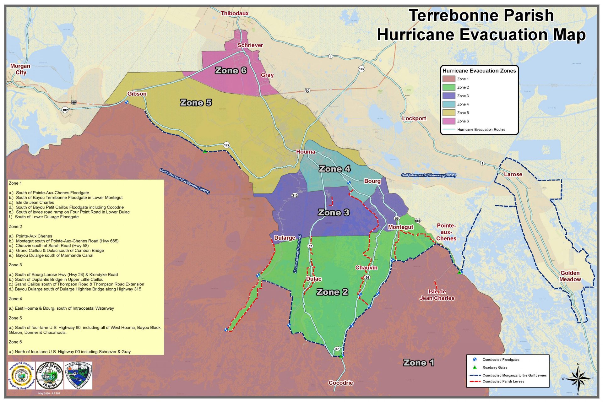
Terrebonne Parish: Mandatory evacuation ordered for Zones 1 and 2; voluntary evacuation issued for Zones 3 and 4
August 27, 2021
Get a Game Plan: How to build an Emergency Kit
August 27, 2021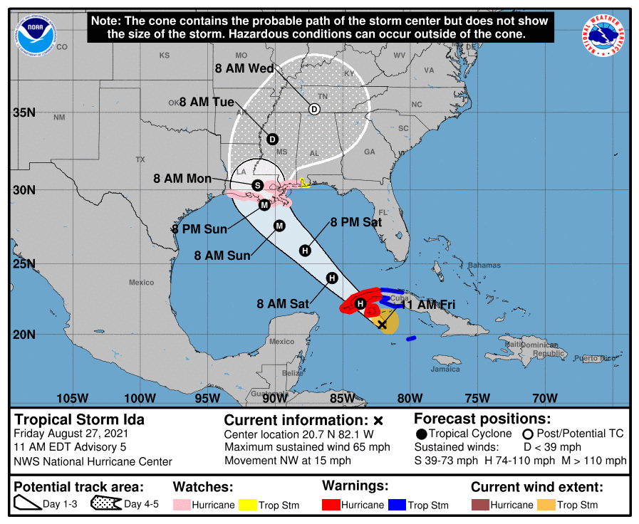
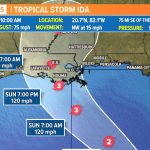
The 10AM update shows Ida rapidly intensifying as it approaches land on Sunday night. The latest forecast predicts wind speeds at 120mph at landfall. A Category 3 storm is 111-129 mph; category 4 storm is 130-156 mph.
The hurricane watch has been extend further inland for Louisiana.

At 1100 AM EDT (1500 UTC), the center of Tropical Storm Ida was located near latitude 20.7 North, longitude 82.1 West. Ida is moving
toward the northwest near 15 mph (24 km/h), and this general motion should continue over the next few days. On the forecast track, the center of Ida will pass near or over the Isle of Youth and western Cuba later today, and move over the southeastern and central Gulf
of Mexico tonight and Saturday. Ida is forecast to make landfall along the U.S. northern Gulf coast within the hurricane watch area
on Sunday.

Reports from Air Force and NOAA reconnaissance aircraft indicate that the maximum sustained winds have increased to near 65 mph
(100 km/h) with higher gusts. Additional strengthening is forecast today and Ida is expected to be a hurricane when it nears western
Cuba later today. Steady to rapid strengthening is expected when Ida moves over the southeastern and central Gulf of Mexico over the
weekend, and Ida is expected to be a major hurricane when it approaches the northern Gulf coast.
Tropical-storm-force winds extend outward up to 90 miles (150 km) from the center. A wind gust to 45 mph (72 km/h) was recently
reported on Cayman Brac and a wind gust to 41 mph (67 km/h) has been observed on Cayo Largo, Cuba, within the past hour or two.
The latest minimum central pressure reported by an Air Force Reserve reconnaissance aircraft is 996 mb (29.42 inches).

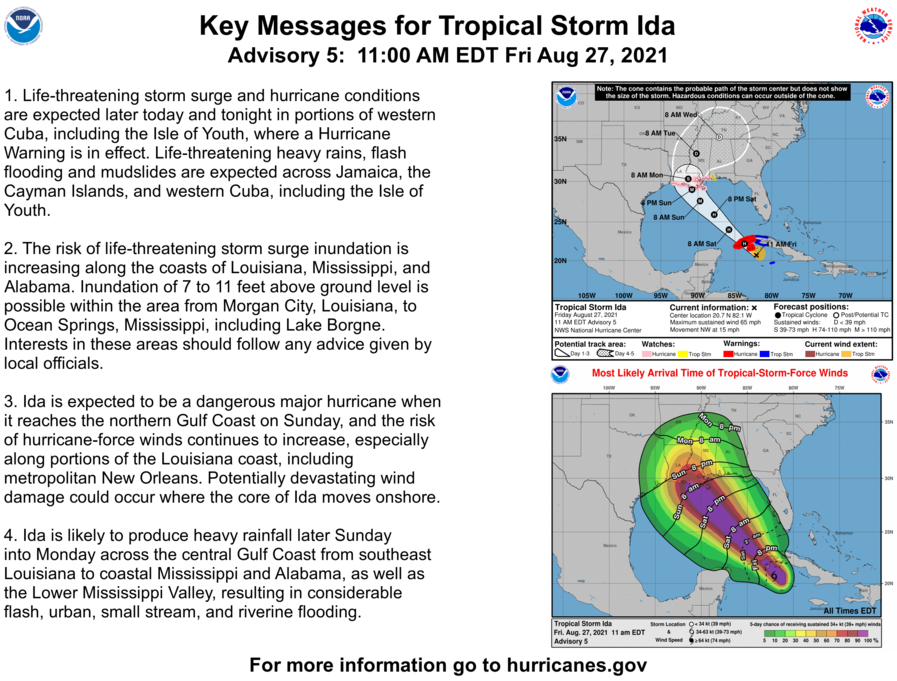
Morgan City, LA to Ocean Springs, MS including Lake Borgne…7-11 ft
Rockefeller Wildlife Refuge, LA to Morgan City, LA including
Vermilion Bay…4-7 ft
Ocean Springs, MS to MS/AL border…4-7 ft
MS/AL border to AL/FL border including Mobile Bay…3-5 ft
Lake Pontchartrain…4-6 ft
Lake Maurepas…3-5 ft
Sabine Pass to Rockefeller Wildlife Refuge, LA…2-4 ft
Overtopping of local levees outside of the Hurricane and Storm Damage Risk Reduction System is possible where local inundation values may be higher than those shown above.

