
Terrebonne Parish Curfew in effect for areas south of Morganza to the Gulf
August 26, 2020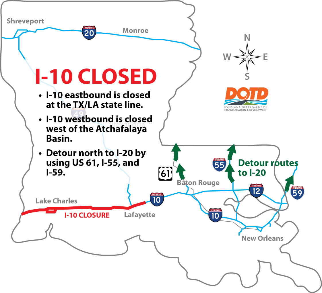
DOTD: I-10 closed to traffic in southwest LA
August 26, 2020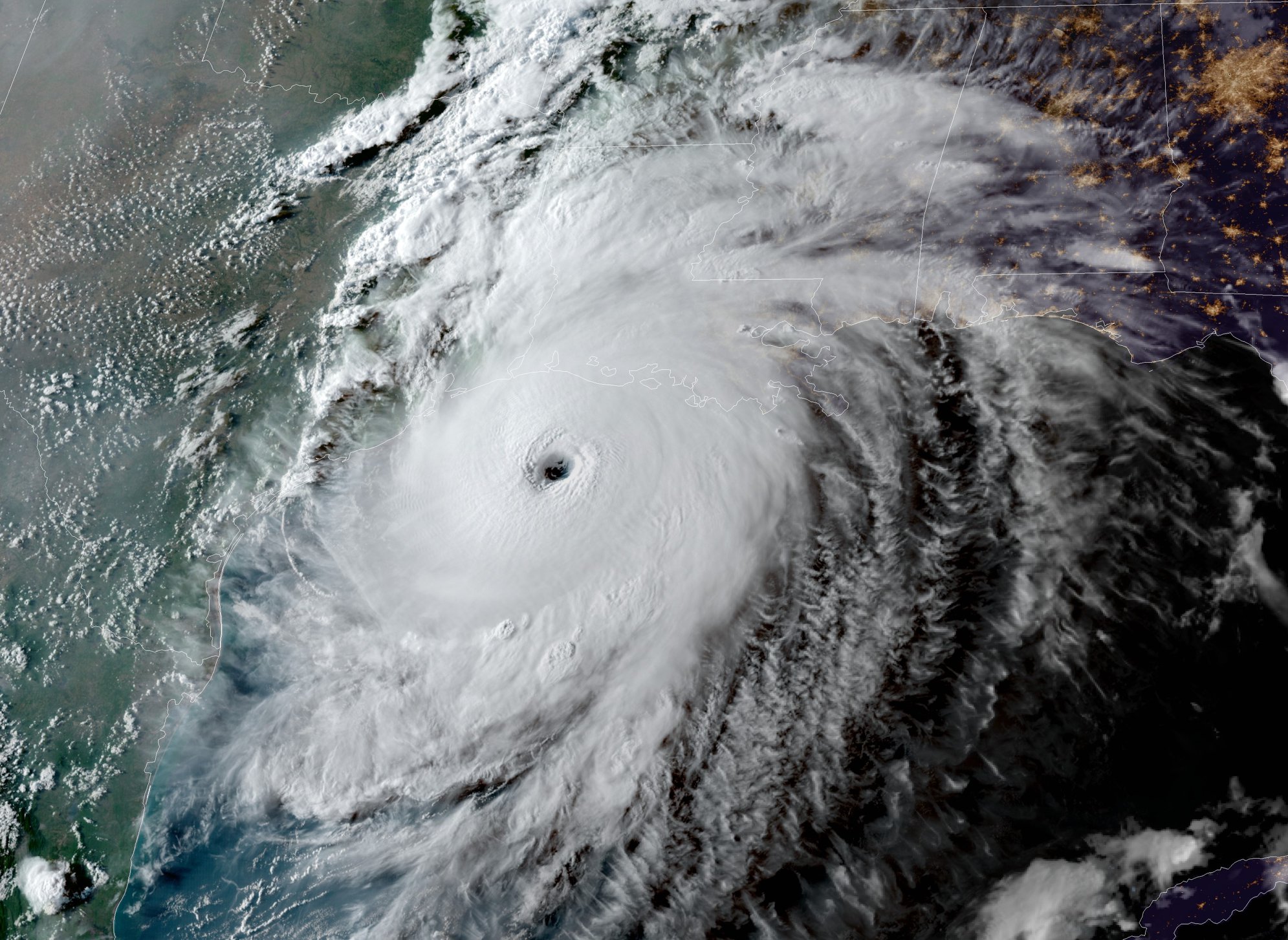
The mood across Louisiana tonight is quite somber as we watch Hurricane Laura approach the coast as a very strong category 4 storm. Laura is about 120 miles south of Lake Charles with current wind speeds of 150 mph. (Category 5 storm is 157+mph) Hurricane-force winds extend outward up to 60 miles (95 km) from the center and tropical-storm-force winds extend outward up to 205 miles (335 km). Max wind gusts today measured 45 mph in Houma and 43 mph at Port Fourchon.

Our area remains under a tornado watch until 9 pm. This may be extended. Several tornadoes are expected this evening through tonight over Louisiana, far southeast Texas, and southwestern Mississippi. The risk for a few tornadoes will continue into Thursday across Louisiana, Arkansas, and western Mississippi.
Hurricane conditions are expected in the hurricane warning area tonight and Thursday, with catastrophic wind damage expected where Laura’s eyewall moves onshore tonight. Tropical storm conditions are moving onshore along the coast of Louisiana within the tropical storm warning area and are expected to spread northwestward within the warning areas this evening. Hurricane-force winds and damaging wind gusts are also expected to spread well inland into portions of eastern Texas and western Louisiana early Thursday.
Unsurvivable storm surge with large and destructive waves will cause catastrophic damage from Sea Rim State Park, Texas, to Intracoastal City, Louisiana, including Calcasieu and Sabine Lakes. This surge could penetrate up to 40 miles inland from the immediate coastline, and flood waters will not fully recede for several days after the storm.

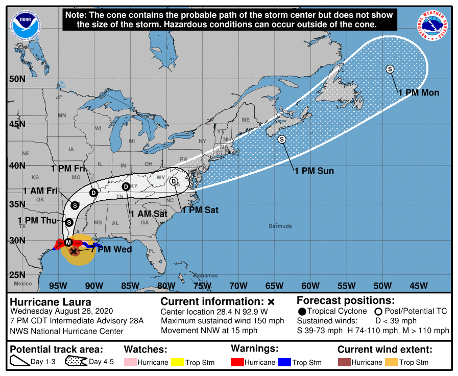
At 7 p.m. CDT, the center of Hurricane Laura was located about 120 miles (190 km) south of Lake Charles, La. It’s moving toward the north-northwest near 15 mph (24 km/h). A turn toward the north is expected overnight, and a northward motion should continue on Thursday. A northeastward to east-northeastward motion is expected Thursday night and Friday. On the forecast track, Laura will approach the upper Texas and southwest Louisiana coasts this evening and move inland within that area tonight. The center of Laura is forecast to move over northwestern Louisiana tomorrow, across Arkansas Thursday night, and over the mid-Mississippi Valley on Friday.
Reports from a NOAA Hurricane Hunter aircraft indicate that the maximum sustained winds have increased to near 150 mph (240 km/h) with higher gusts – an extremely dangerous category 4 hurricane on the Saffir-Simpson Hurricane Wind Scale. A sustained wind of 48 mph (78 km/h) was recently reported at Cypremort Point, Louisiana, on Vermilion Bay. Some additional strengthening is possible tonight before Laura reaches the northwest Gulf coast overnight. Rapid weakening is expected after Laura moves inland.

