
Looking ahead: Nicholls cross country program ready to run this spring
August 23, 2020
Marco strengthens into a Hurricane, Category 1
August 23, 2020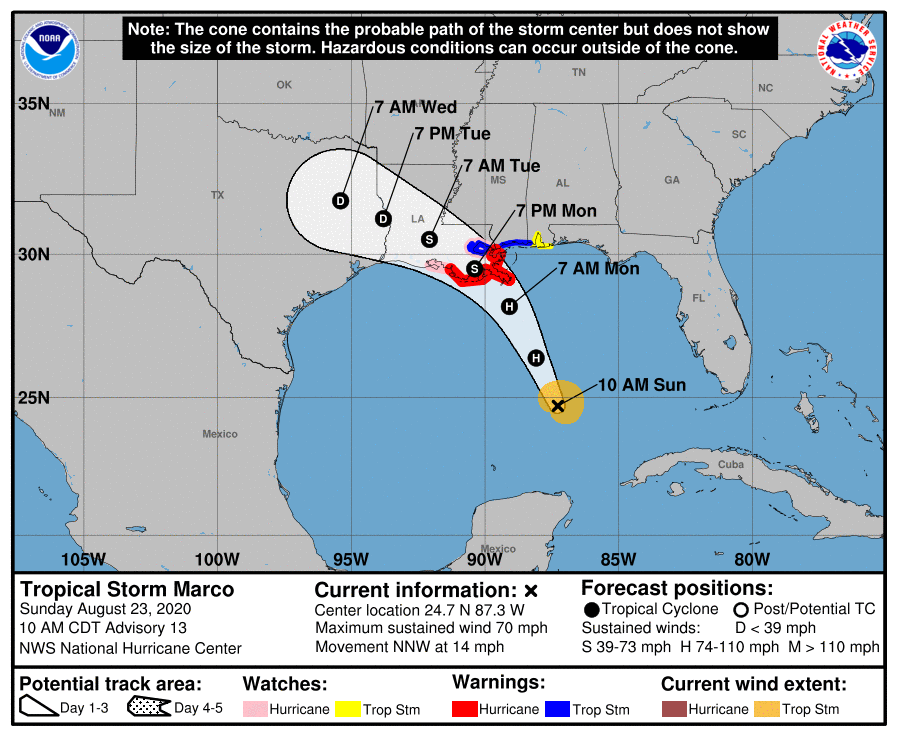
Not much change at the 10am advisory in the path of TS Marco. While strengthening is expected this afternoon, the storm is holding steady at this hour with 70mph winds. Terrebonne and Lafourche are still in the storm’s aim. The storm is expected to rapidly weaken after landfall.

At 10 a.m. CDT, the center of Tropical Storm Marco was located about 325 miles (520 km) south-southeast of the mouth of the Mississippi River. It’s moving toward the north-northwest near 14 mph (22 km/h), and this motion is expected to continue through tonight, followed by a turn to the northwest by Monday. On the forecast track, Marco will cross the central Gulf of Mexico today and will approach southeastern Louisiana on Monday. A gradual turn toward the west-northwest with a decrease in forward speed is expected after Marco moves inland.
Maximum sustained winds are near 70 mph (110 km/h) with higher gusts. Tropical-storm-force winds extend outward up to 70 miles (110 km) from the center. Some strengthening is anticipated and Marco is forecast to become a hurricane later today and be at hurricane strength when it approaches the northern Gulf Coast on Monday. Rapid weakening is expected after Marco moves inland.
The combination of a dangerous storm surge and the tide will cause normally dry areas near the coast to be flooded by rising waters moving inland from the shoreline. The water could reach the following heights above ground somewhere in the indicated areas if the peak surge occurs at the time of high tide…
– Morgan City LA to Ocean Springs MS including Lake Borgne…4-6 ft
– Sabine Pass to Morgan City LA…2-4 ft
– – Ocean Springs MS to the MS/AL Border…2-4 ft
Lake Pontchartrain and Lake Maurepas…2-4 ft
– MS/AL state line to AL/FL state line, including Mobile Bay…1-3 ft

Marco is expected to produce rainfall accumulations of 2 to 4 inches with isolated maximum amounts of 6 inches across the Central U.S. Gulf coast through Tuesday. This rainfall may result in isolated areas of flash and urban flooding along the Central U.S. Gulf Coast.
The next complete advisory will be issued by NHC at 4 p.m. CDT with an intermediate advisory at 1 p.m. CDT