
Tropical Storm Laura forms in the Atlantic
August 21, 2020
Houma native to appear on ‘Today’ show to share weight loss story
August 21, 2020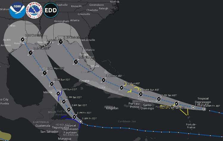
The newest updates are in.
Tropical Storm Laura has formed in the Atlantic. It’s moving toward the west near 18 mph (30 km/h) and a generally west-northwestward motion at a faster forward speed is expected over the next couple of days. The current path takes shows it increasing to a hurricane Monday evening or Tuesday, with landfall around Alabama/Florida on Wednesday.
Tropical Depression 14 is forecast to become a tropical storm later today. The system is forecast to be near or at hurricane strength when it reaches the Yucatan Peninsula of Mexico late Saturday. Some weakening is expected as it moves over the Yucatan Peninsula Saturday night. Afterward, restrengthening is forecast on Sunday as it moves offshore and enters the southern Gulf of Mexico.

 Tropical Storm Laura
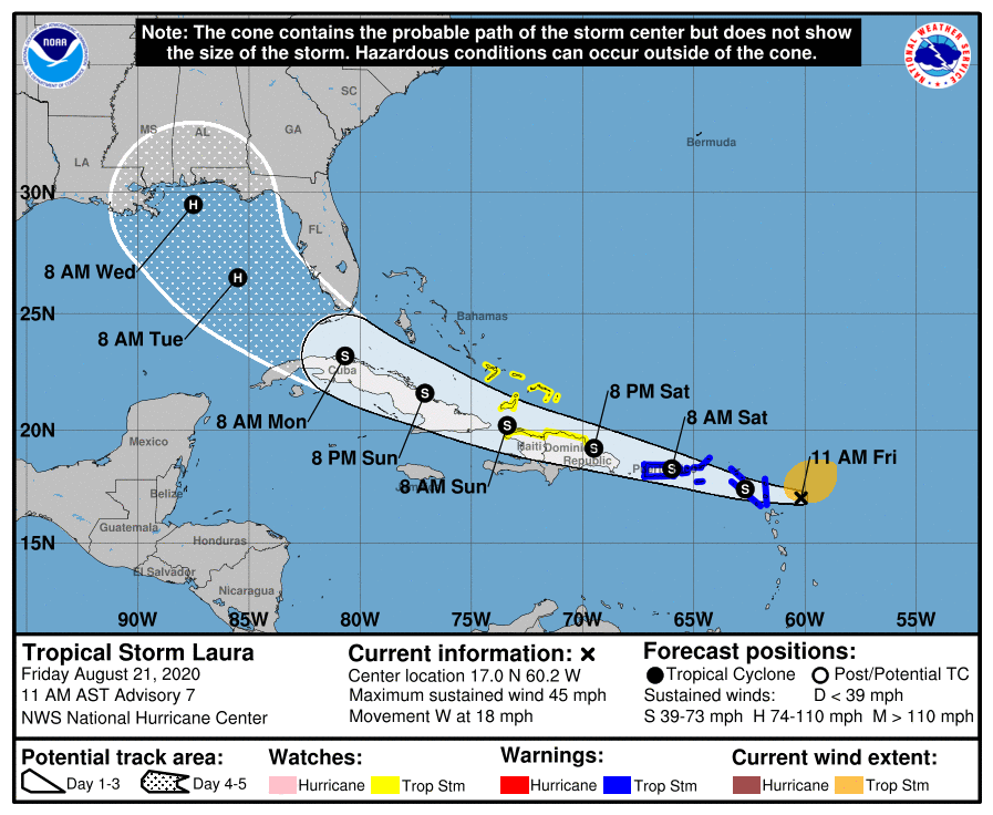
At 11 a.m. AST, the center of Tropical Storm Laura was located over the Atlantic Ocean about 210 miles (335 km) east-southeast of the northern Leeward Islands. It’s moving toward the west near 18 mph (30 km/h) and a generally west-northwestward motion at a faster forward speed is expected over the next couple of days. On the forecast track, the center of Laura will move near or over the northern Leeward Islands later today, near or over Puerto Rico Saturday morning, and near the northern coast of Hispaniola late Saturday and early Sunday.
Maximum sustained winds are near 45 mph (75 km/h) with higher gusts. Tropical-storm-force winds extend outward up to 150 miles (240 km) from the center. Some slow strengthening is forecast to occur during the next 48 hours.

Laura is expected to produce 3 to 6 inches of rain over Puerto Rico and the Virgin Islands, the Dominican Republic, and the southern Haitian Peninsula through Sunday. Maximum amounts up to 8 inches are possible along eastern portions and the southern slopes of Puerto Rico, as well as over Haiti and the Dominican Republic. This heavy rainfall could lead to flash and urban flooding, as well as an increased potential for mudslides with minor river flooding in Puerto Rico. 1 to 3 inches of rain with isolated maximum totals of 5 inches is expected over the remainder of Haiti, the northern Leeward Islands, the Turks and Caicos and southeast Bahamas.
The details of the long-range track and intensity forecasts remain more uncertain than usual since Laura is forecast to move near or over portions of the Greater Antilles through Monday. However, Laura could bring storm surge, rainfall, and wind impacts to portions of Cuba, the Bahamas, and Florida early next week and the northeast U.S. Gulf Coast by the middle of next week. Interests there should monitor the progress of Laura and updates to the forecast over the next few days.
Tropical Depression Fourteen

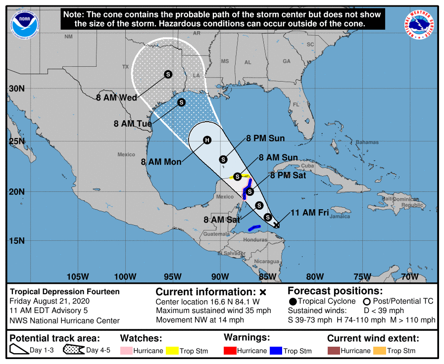
At 11 a.m., EDT, the center of Tropical Depression Fourteen was located over the western Caribbean Sea about 165 miles (270 km) east of Isla Roatan, Honduras. It’s moving toward the northwest near 14 mph (22 km/h). A slower northwestward motion is expected over the next couple of days, followed by an increase in speed by Sunday and Monday. On the forecast track, the center of the depression will move away from the coast of Honduras today, approach the east coast of the Yucatan Peninsula of Mexico on Saturday, cross the northeastern part of the Yucatan Peninsula Saturday night and then move over the central Gulf of Mexico toward the northwestern Gulf on Sunday and Monday.
Maximum sustained winds are near 35 mph (55 km/h) with higher gusts. Strengthening is forecast to take place during the next couple of days. The system is expected to move into the south-central Gulf of Mexico as a tropical storm on Sunday. Some strengthening is anticipated while it moves northwestward over the central Gulf of Mexico early next week, but it is too soon to know exactly how strong it will get or the location and magnitude of impacts it will produce along the central or northwestern Gulf Coast. Interests in that area should continue monitoring the progress of this system over the next few days.

