
Delta strengthens to a category 2 again
October 8, 2020
Friday Night Lights Scoreboard: Week 2
October 8, 2020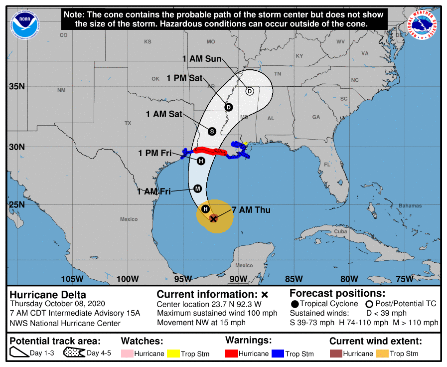
No real changes with the intermediate advisory. Hurricane Delta is still a category 2 storm, with strengthening expected in the next 24 hours to a category 3. The storm is expected to make landfall to our west as a strong category 2. Tropical force winds will arrive beginning tomorrow, so please consider making final preparations today. Terrebonne and Lafourche remain under a tropical storm and storm surge warning. Residents under a mandatory evacuation south of the levee system in Terrebonne should heed the order.
At 7 a.m. CDT, the center of Hurricane Delta was located over the Gulf of Mexico about 425 miles (685 km) south of Cameron, Louisiana. Delta is moving toward the northwest near 15 mph (24 km/h), and this motion with a reduction in forward speed is expected today. On the forecast track, the center of Delta will move over the central Gulf of Mexico today, and move inland within the hurricane warning area Friday afternoon or Friday night.

Reports from the Hurricane Hunter aircraft indicate that maximum sustained winds are near 100 mph (155 km/h) with higher gusts – a category 2 hurricane on the Saffir-Simpson Hurricane Wind Scale. Hurricane-force winds extend outward up to 35 miles (55 km) from the center and tropical-storm-force winds extend outward up to 125 miles (205 km). Strengthening is forecast to occur, and Delta is expected to become a major hurricane again by tonight. Some weakening is forecast when Delta approaches the northern Gulf coast on Friday.
The combination of a dangerous storm surge and the tide will cause normally dry areas near the coast to be flooded by rising waters moving inland from the shoreline. The water could reach the following heights above ground somewhere in the indicated areas if the peak surge occurs at the time of high tide…
– Pecan Island to Port Fourchon, LA incl. Vermilion Bay…7-11 ft
– Cameron, LA to Pecan Island, LA…4-7 ft
– Port Fourchon, LA to the Mouth of the Mississippi River…4-6 ft
– Mouth of the Mississippi River to Ocean Springs, MS…3-5 ft

– Lake Borgne, Lake Pontchartrain, & Lake Maurepas…3-5 ft
– High Island, TX to Cameron, LA incl. Calcasieu Lake…2-4 ft
– Ocean Springs, MS to MS/AL state line…1-3 ft

– MS/AL state line to the AL/FL state line incl. Mobile Bay…1-3 ft
– Sabine Lake…1-3 ft
– Port O’Connor, TX to High Island, TX incl. Galveston Bay…1-3 ft.

Friday through Saturday, Delta is expected to produce 5 to 10 inches of rain, with isolated maximum totals of 15 inches, for southwest into south central Louisiana. These rainfall amounts will lead to significant flash, urban, small stream flooding, along with minor to isolated moderate river flooding. For extreme east Texas into northern Louisiana, southern Arkansas and western Mississippi, Delta is expected to produce 3 to 6 inches of rain, with isolated maximum totals of 10 inches. These rainfall amounts will lead to flash, urban, small stream and isolated minor river flooding.
The next complete advisory will be issued by NHC at 10 a.m. CDT

