
Gov. Edwards Enacts Juneteenth Day as Legal State Holiday; All State Offices to Close this Friday for Half-Day
June 17, 2021
TPCG warns of utilities billing scam
June 18, 2021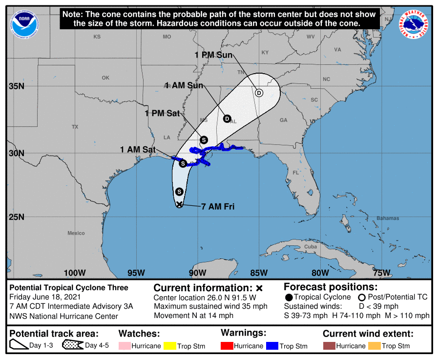
Potential Tropical Cyclone Three is still hanging out in the Gulf, moving our way. It is expected to make landfall in Terrebonne Parish tonight. It is still quite lopsided, with all the rain found on the eastern side. It is still forecast to become Claudette later today. Our area’s biggest impact will be rain.

At 700 AM CDT (1200 UTC), the broad area of low pressure was centered near latitude 26.0 North, longitude 91.5 West, about 255 miles south of Morgan City. The system is moving toward the north near 14 mph (22 km/h), and this general motion is expected for the next day or so. On the forecast track, the system will approach the north-central Gulf Coast tonight or early Saturday. A slow northeastward motion across the southeastern United States is likely after landfall through the weekend.
Maximum sustained winds are near 35 mph (55 km/h) with higher gusts. Some strengthening is forecast, and a subtropical or tropical storm is likely to form over the central or northern Gulf of Mexico later today.
* Formation chance through 48 hours…high…90 percent.
* Formation chance through 5 days…high…90 percent.
The estimated minimum central pressure is 1007 mb (29.74 inches), based on surface observations.

Rainfall totals of 4 to 8 inches with isolated maximum amounts of 12 inches are expected across portions of the Central Gulf Coast beginning today. Considerable flash, urban and small stream flooding impacts as well as new and renewed minor to isolated moderate river flooding are likely.
As the system continues to lift northeast through the weekend, anticipate heavy rain to expand across southeastern Mississippi, southern and central Alabama, and central Georgia resulting in rainfall totals of 3 to 5 inches with isolated maximum amounts of 7 inches. Flash, urban, small stream and isolated minor river flooding impacts are possible.


