
Bollinger Awarded Contract for Concept Study, Preliminary Design of U.S. Navy’s Light Amphibious Warship
June 18, 2021
Nicholls Sales Program Among the Best in North America
June 18, 2021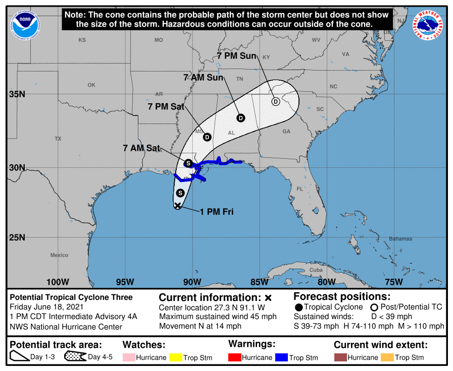
At the noon update, Potential Tropical Cyclone Three continues its journey NNE towards the Louisiana/Mississippi coast at 14 mph. It is currently 165 miles south of Morgan City.

Satellite data indicate that maximum sustained winds have increased to near 45 mph (75 km/h) with higher gusts. The circulation is gradually becoming better defined, and a tropical storm is likely to form over the north-central Gulf of Mexico later today or tonight. The forecast from NHC puts landfall south of Chauvin, early Saturday morning around 1AM. The landfall position has moved further east from the 7AM advisory.
Indications are that Terrebonne and Lafourche should start seeing tropical storm winds near 6PM this evening. The storm is forecast to move quickly to the northeast after landfall. Rainfall potential is 4-6 inches with the potential of higher rates depending on the location of rain bands. If landfall of the storm continues to move eastward, rainfall rates should decrease, but we need to be prepared for the higher rainfall rates.
GLPC has opened the Emergency Storm Harbor Marina to commercial fishing vessels seeking safe harbor within the South Lafourche Levee System. Utilization of this marina will be on a first come, first served basis. Harbor Police will be on scene to monitor marina activity.
From NHC: At 100 PM CDT (1800 UTC), the disturbance was centered near latitude 27.3 North, longitude 91.1 West. The system is moving toward the north near 14 mph (22 km/h), and a north to north-northeast motion is expected during the next day or so. On the forecast track, the system will make landfall along the north-central Gulf Coast tonight or early Saturday. A northeastward motion across the southeastern United States is likely after landfall through the weekend.
Tropical-storm-force winds extend outward up to 205 miles east of the center. A NOAA C-MAN station at the Southwest Pass of the Mississippi River recently reported sustained winds of 44 mph (71 km/h) and a wind gust of 51 mph (82 km/h) at an elevation of 125 feet (38 meters).
The estimated minimum central pressure based on data from the Air Force Hurricane Hunters and surface observations is 1007 mb (29.74 inches).
