
Terrebonne will offer Pre-filled sandbags on Sunday
August 22, 2020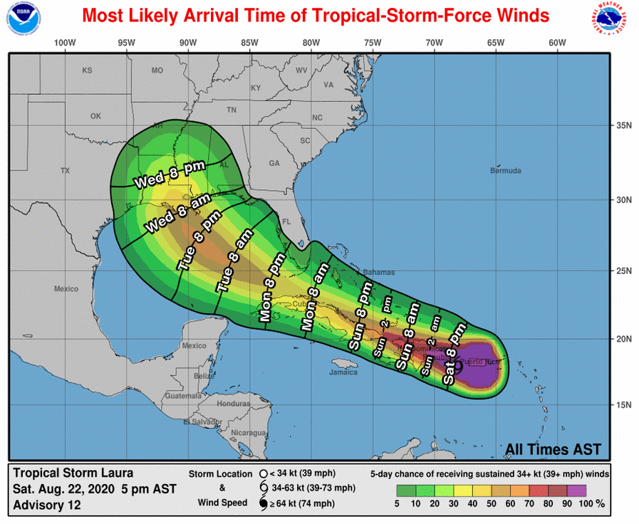
See 7 p.m. update for Topical Storm Laura
August 22, 2020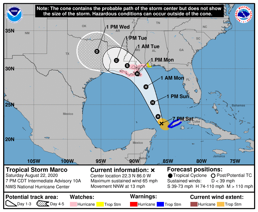
…MARCO ENTERS THE GULF OF MEXICO…
…STORM SURGE AND HURRICANE WATCHES IN EFFECT FOR PORTIONS OF THE NORTHERN GULF COAST…
A Storm Surge Watch continues for…
* Sabine Pass to the Alabama/Florida state line and for Lake Pontchartrain, Lake Maurepas, Lake Borgne, and Mobile Bay
A Hurricane Watch continues for…
* Intracoastal City Louisiana to the Mississippi/Alabama state line, and for Lake Pontchartrain, Lake Maurepas, and Metropolitan New Orleans.
A Tropical Storm Warning continues for…
* Province of Pinar del Rio Cuba
A Tropical Storm Watch is in effect for…
* Mississippi/Alabama state line to the Alabama/Florida state line
Hurricane conditions are possible within the hurricane watch
area by midday Monday, with tropical storm conditions possible by early Monday. Tropical storm conditions are possible within the tropical storm watch area on Monday. Tropical storm conditions are expected to continue within the
warning area in Cuba through this evening.
At 7 p.m., CDT, the center of Tropical Storm Marco was located about 510 miles (820 km) south-southeast of the mouth of the Mississippi River. It’s moving toward the north-northwest near 13 mph (20 km/h). Marco is expected to continue moving toward the north-northwest across the central Gulf of Mexico on Sunday and is forecast to reach the northern Gulf coast on Monday. After moving inland, Marco is expected to slow down and turn toward the northwest and west-northwest Monday night and Tuesday, moving across southern Louisiana and east Texas.
Maximum sustained winds based on preliminary data from the reconnaissance aircraft are near 65 mph (100 km/h) with higher gusts. Tropical-storm-force winds extend outward up to 90 miles (150 km) from the center Strengthening is forecast during the next day or two, and Marco is expected to become a hurricane later tonight or on Sunday. Marco is likely to still be at or near hurricane strength when it reaches the northern Gulf coast on Monday. Weakening is forecast to occur while the center moves farther inland Monday night and Tuesday.
The combination of a dangerous storm surge and the tide will cause normally dry areas near the coast to be flooded by rising waters moving inland from the shoreline. The water could reach the following heights above ground somewhere in the indicated areas if the peak surge occurs at the time of high tide…
– Grand Isle LA to the AL/FL Border incl. Lake Borgne and Mobile Bay…3-5 ft
– Lake Pontchartrain and Lake Maurepas…2-4 ft
– Sabine Pass to Grand Isle LA…2-4 ft
The next complete advisory will be issued by NHC at 10 p.m. CDT –

