UPDATE: SBA extends deadline for applying for physical damages from Ida to Nov. 29
October 27, 2021
FOUND: Silver Alert Issued for Missing Ville Platte Man
October 28, 2021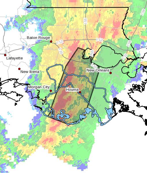
The National Weather Service in New Orleans has issued a Severe Thunderstorm Warning for St. John The Baptist Parish, East central Ascension Parish, St. James Parish, St. Charles Parish, Terrebonne Parish, Southeastern Livingston Parish, Northwestern Lafourche Parish, and Southeastern Assumption Parish until 600 PM CDT.

At 521 PM CDT, severe thunderstorms were located along a line extending from Whitehall to Wallace to 15 miles west of Cocodrie, moving northeast at 45 mph with 60 mph wind gusts.
Locations impacted include Houma, Thibodaux, Reserve, Hahnville, Laplace, Gramercy, Lutcher, Lockport, Mathews, Schriever, Montz, Chauvin, Dulac, Luling, Garyville, Boutte, Raceland, Ama, Chackbay and Destrehan.
This includes the following Interstates…
Interstate 10 in Louisiana between mile markers 187 and 221.
Interstate 55 in Louisiana between mile markers 1 and 12.
Interstate 310 between mile markers 1 and 11.

PRECAUTIONARY/PREPAREDNESS ACTIONS…
A Tornado Watch remains in effect until 1000 PM CDT for southeastern Louisiana. For your protection move to an interior room on the lowest floor of a building. Squall lines can produce brief tornadoes and straight-line wind damage. Although a tornado is not immediately likely, it is best to move to an interior room on the lowest floor of a building. These storms may cause serious injury and significant property damage.

