
Sally slows off the coast; hurricane warnings dropped for our area
September 15, 2020
LA 1 closed from Fourchon to Grand Isle
September 15, 2020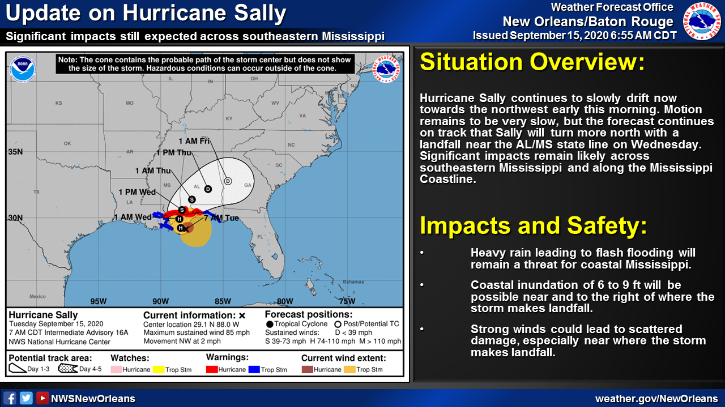
With the 7 a.m. advisory, the tropical storm warning has been canceled for our area. Only Grand Isle remains under a tropical storm warning. No major changes as the forecast track continues to have Sally turn more north, with a forecast landfall near the Alabama and Mississippi state line. Life-threatening storm surge, hurricane force winds and torrential rainfall are expected to move into the area on Tuesday along the Mississippi Gulf coast.

At 7 a.m. CDT, the center of Hurricane Sally was located about 65 miles (110 km) east-southeast of the mouth of the Miss. River and about 105 miles (170 km) south-southeast of Biloxi, Miss. Sally is moving toward the northwest near 2 mph (4 km/h), and this general motion is expected to continue this morning. A northward turn is expected this afternoon, followed by a slow north-northeastward to northeastward motion tonight and continuing through Wednesday night. On the forecast track, the center of Sally will pass near the coast of southeastern Louisiana today, and make landfall in the hurricane warning area tonight or Wednesday morning.
Maximum sustained winds are near 85 mph (140 km/h) with higher gusts – a category 1 hurricane on the Saffir-Simpson Hurricane Wind Scale. Hurricane-force winds extend outward up to 45 miles (75 km) from the center and tropical-storm-force winds extend outward up to 125 miles (205 km). Although little change in strength is forecast until landfall occurs, Sally is still expected to be a dangerous hurricane when it moves onshore along the north-central Gulf coast.

