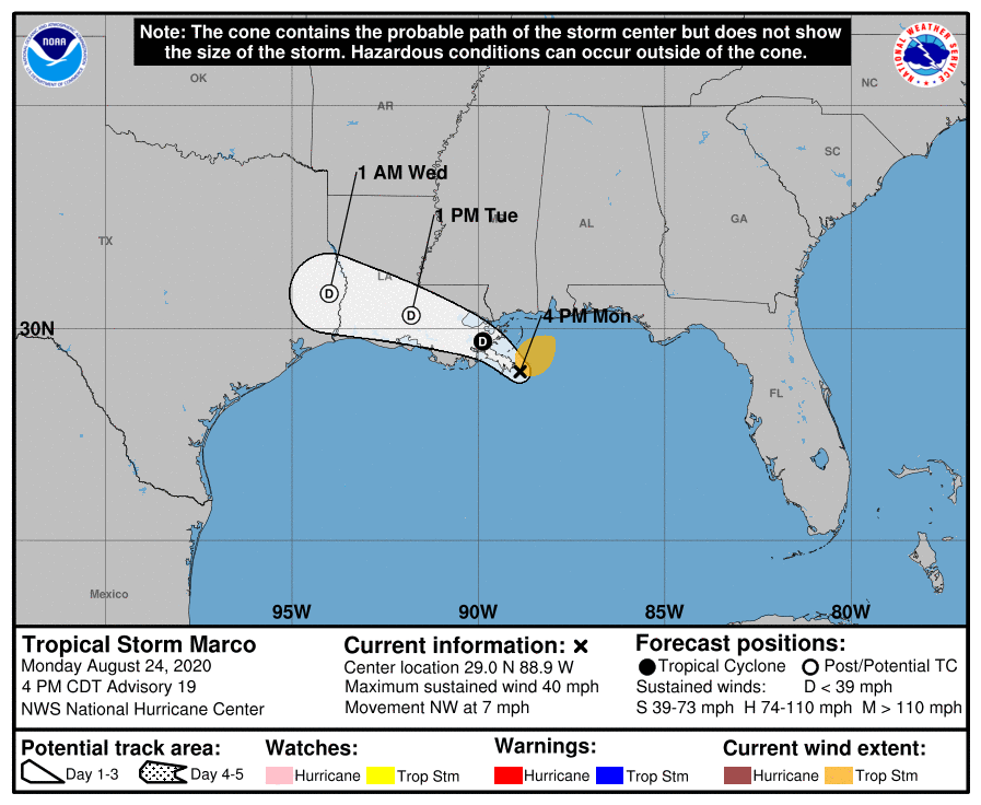
TS Marco still lingering off the coast
August 24, 2020
Houma rally to bring awareness to child abuse, trafficking and provide educational resources
August 24, 2020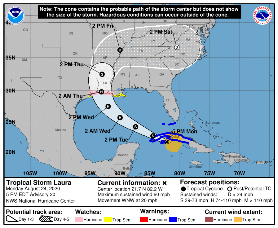
Our area is beginning to prepare for Laura, even though Marco has yet to make landfall. Hurricane conditions are possible in the hurricane watch area along the Gulf Coast by late Wednesday, with tropical storm conditions possible by Wednesday afternoon.

A Hurricane Watch is in effect for Port Bolivar Texas to west of Morgan City, Louisiana.
A Tropical Storm Watch is in effect for Morgan City, Louisiana to the Mouth of the Mississippi River.
At 5 p.m. EDT, the center of Tropical Storm Laura was located about 40 miles (65 km) east of the Isle of Youth. It’s moving toward the west-northwest near 20 mph (31 km/h), and this general motion with some decrease in forward speed is expected over the next day or so. A turn toward the west-northwest near 20 mph (31 km/h), and this general motion with some decrease in forward speed is expected during the next day or so. A turn toward the northwest is forecast by Wednesday, and a northwestward to north-northwestward motion should continue through Wednesday night. On the forecast track, the center of Laura will cross western Cuba this evening and move into the southeastern Gulf of Mexico overnight, move over the central and northwestern Gulf of Mexico Tuesday night and Wednesday, and then approach the northwestern coast of the Gulf of Mexico Wednesday night.

Maximum sustained winds are near 60 mph (95 km/h) with higher gusts. Tropical-storm-force winds extend outward up to 175 miles (280 km) primarily to the northeast and east of the center. Strengthening is expected when the storm moves over the Gulf of Mexico, and Laura is forecast to become a hurricane by late Tuesday. Additional strengthening is forecast on Wednesday.
The combination of a dangerous storm surge and the tide will cause normally dry areas near the coast to be flooded by rising waters moving inland from the shoreline. The water could reach the following heights above ground somewhere in the indicated areas if the peak surge occurs at the time of high tide…
– High Island TX to Morgan City LA including Sabine Lake, Calcasieu Lake, and Vermilion Bay…7-11 ft
– Port Bolivar TX to High Island TX…4-6 ft
– Morgan City LA to Mouth of the Mississippi River…4-6 ft
– Mouth of the Mississippi River to Ocean Springs MS including Lake – Borgne…3-5 ft
– San Luis Pass TX to Port Bolivar TX…2-4 ft
— Galveston Bay…2-4 ft
Lake Pontchartrain and Lake Maurepas…2-4 ft

From Wednesday afternoon into Saturday, Laura is expected to produce rainfall of 4 to 8 inches, with isolated maximum amounts of 12 inches across portions of the west-central U.S. Gulf Coast near the Texas and Louisiana border north into portions of the lower Mississippi Valley. This rainfall could cause widespread flash and urban flooding, small streams to overflow their banks, and minor to isolated moderate river flooding.
The next complete advisory will be issued by NHC at 11 p.m. EDT with an intermediate advisory at 8 p.m. EDT

