
BCCM announces interim executive director
September 21, 2022
Ivy J. Bonvillain, Jr.
September 21, 2022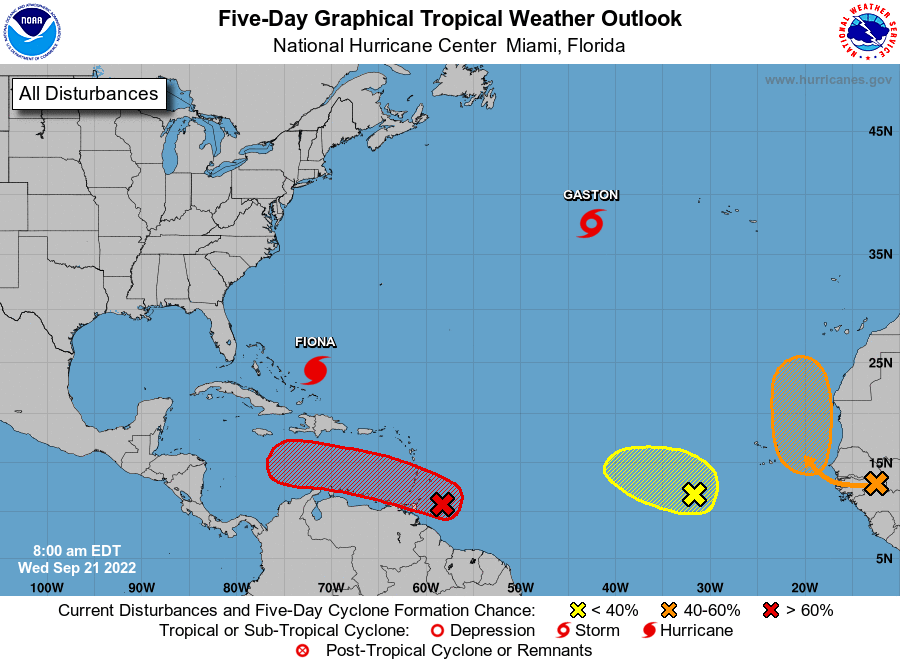
The National Hurricane Center is issuing advisories on Hurricane Fiona, located northeast of the southeastern Bahamas, and on Tropical Storm Gaston, located over the north-central Atlantic Ocean. Neither storm is currently a threat to the United States.
A few waves have started catching the attention of the NHC and one in particular will be worth keeping an eye on. Lots of uncertainty at this point, but worth keeping an eye on.
1. Western Tropical Atlantic: (shown in red)
A tropical wave is producing shower and thunderstorm activity a couple hundred miles east of the southern Windward Islands. The system continues to show signs of organization, and it will likely become a tropical depression within the next couple of days. The disturbance is forecast to move west-northwestward across the southern Windward Islands today and then move toward the central Caribbean Sea later this week. Interests in the Windward Islands should closely monitor the progress of this system as heavy rainfall and gusty winds are affecting these islands. Regardless of development, heavy rainfall is forecast to affect northwestern Venezuela, northeastern Colombia, and the ABC island chain later this week. It has a high (70 percent) chance of formation during the next 48 hours and a high (90 percent) chance in the next 5 days.

2. Eastern Tropical Atlantic: (shown in orange)
A tropical wave is forecast to move off the west coast of Africa on Thursday. Thereafter, environmental conditions are forecast to be conducive for some development, and a tropical depression could form this weekend while the system moves slowly northward, between west Africa and the Cabo Verde Islands. It has a low (20 percent) chance of formation during the next 48 hours and a medium (50 percent) chance in the next 5 days.
3. East Central Tropical Atlantic: (shown in yellow)
Shower and thunderstorm activity has increased in association with a tropical wave located several hundred miles west-southwest of the Cabo Verde Islands. Despite a dry environment, slow development of this system is possible over the next several days as it moves northwestward and then westward over the tropical Atlantic. It has a low (20 percent) chance of formation during the next 48 hours and a low (30 percent) chance in the next 5 days.

