Terrebonne floodgates closing ahead of tropical weather
July 23, 2020
Diocese of Houma-Thibodaux announces first day of school for elementary will be August 14
July 23, 2020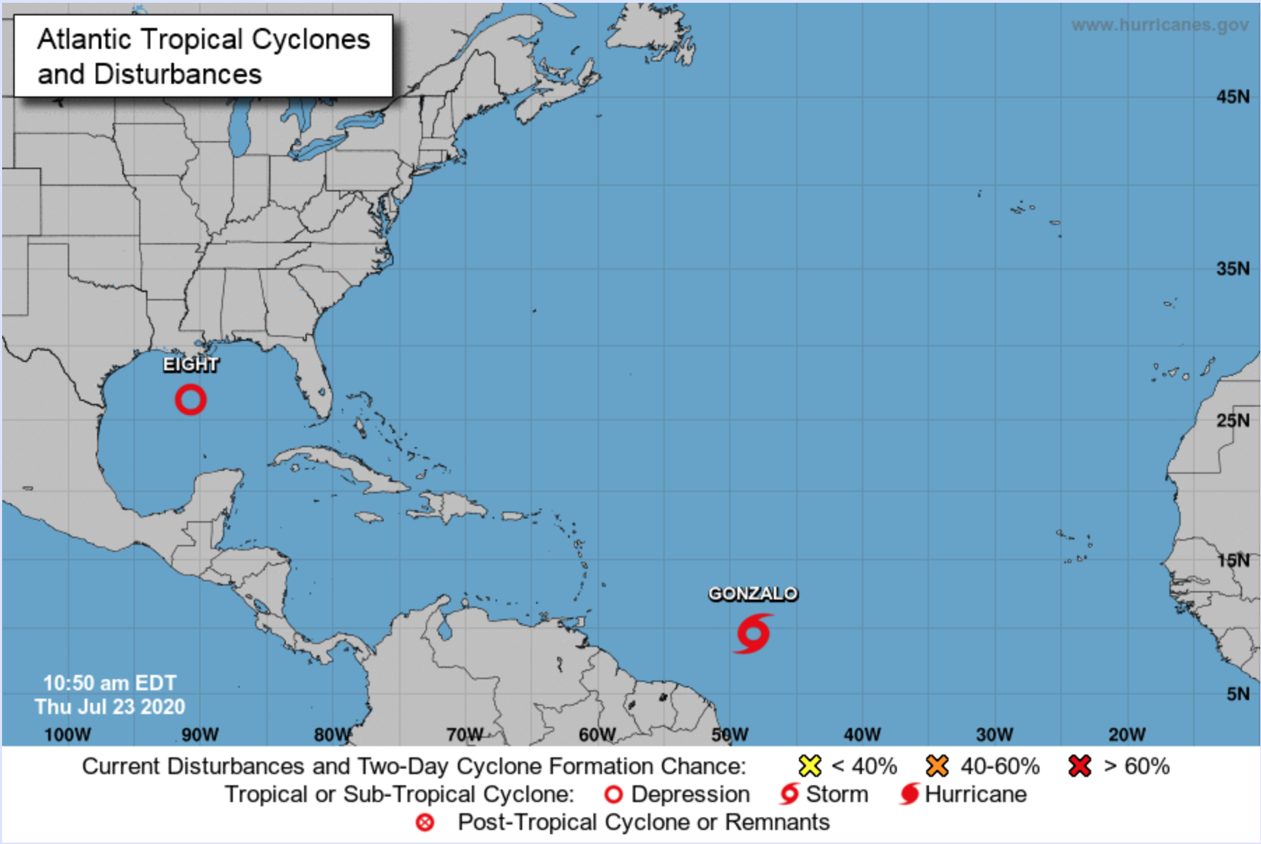
From the National Hurricane Center:
Tropical Storm Gonzalo
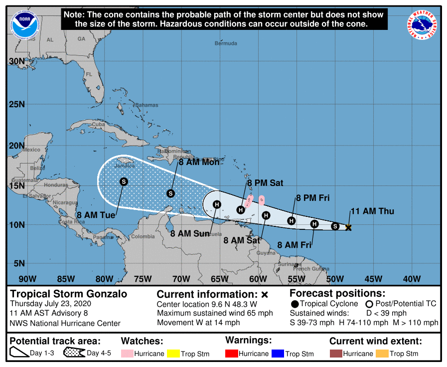
At 11 a.m. AST, the center of Tropical Storm Gonzalo was located over the Atlantic Ocean about 885 miles (1425 km) east of the southern Windward Islands. It’s moving toward the west near 14 mph (22 km/h). A westward to west-northwestward motion with an increase in forward speed is expected through the weekend. On the forecast track, the center will approach the southern Windward Islands Friday night and move across the islands Saturday and Saturday evening.
A Hurricane Watch is in effect for Barbados, St. Vincent and the Grenadines. Hurricane conditions are possible within the watch area by Saturday afternoon, with tropical storm conditions possible by midday Saturday.

Maximum sustained winds are near 65 mph (100 km/h) with higher gusts. Gonzalo is a small storm, and tropical-storm-force winds extend outward up to 35 miles (55 km) from the center. Some strengthening is forecast to occur during the next couple of days, and Gonzalo could become a hurricane tonight or on Friday.
Gonzalo is expected to produce total rain accumulations of 2 to 5 inches, with isolated maximum amounts of 7 inches inBarbados and the Windward Islands from Friday night through Sunday night. Gonzalo is also expected to produce total rain accumulations of 1 to 2 inches in Trinidad and Tobago. Rainfall in Barbados and the Windward Islands could lead to life-threatening flash floods.
The next complete advisory will be issued by NHC at 5 p.m a.m. AST with an intermediate advisory at 2 p.m. AST.
Tropical Depression 8
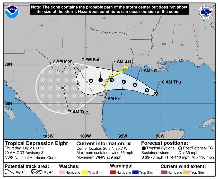
At 10 a.m. CDT, the center of Tropical Depression Eight was located over the Gulf of Mexico about 380 miles (610 km) east-southeast of Port O’Conner, Texas. It’s moving toward the west-northwest near 9 mph (15 km/h), and a west-northwestward to westward motion is expected during the next couple of days. On the forecast track, the center is expected to move across the northwestern Gulf of Mexico today and Friday and make landfall along the Texas coast on Saturday.
A Tropical Storm Watch is in effect along the Texas coastline from Port Mansfield to High Island. Tropical storm conditions are possible within the watch area by Friday night. Interests elsewhere along the Texas and Louisiana coast should monitor the progress of this system. Tropical Storm Warnings may be required for portions of the Watch area later today.
Maximum sustained winds are near 35 mph (55 km/h) with higher gusts. Slow strengthening is expected, and the depression could become a tropical storm during the next 12 to 24 hours. If that occurs, it will be named Hanna. An Air Force Reserve Hurricane Hunter aircraft is currently en route to investigate the depression.
The tropical depression is expected to produce 3 to 5 inches of rain with isolated maximum totals of 8 inches through Monday along the Gulf Coast from Louisiana to the Lower Texas Coast, and inland through south-central Texas and the Rio Grande Valley. This rain may result in flash flooding, rapid rises on small streams, and isolated minor flooding across the west-central Gulf Coast and into portions of south Texas.
Swells generated by the depression are expected to increase and affect much of the Texas and Louisiana coasts in a day or two. These swells are likely to cause life-threatening surf and rip current conditions.
The next complete advisory will be issued by NHC at 4 p.m. CDT with an intermediate advisory at 1 p.m. CDT