
Looking ahead: Nicholls volleyball team ready to ‘fight’ when season resumes
August 22, 2020
Lafourche Parish announces sand bag distribution locations for Sunday
August 22, 2020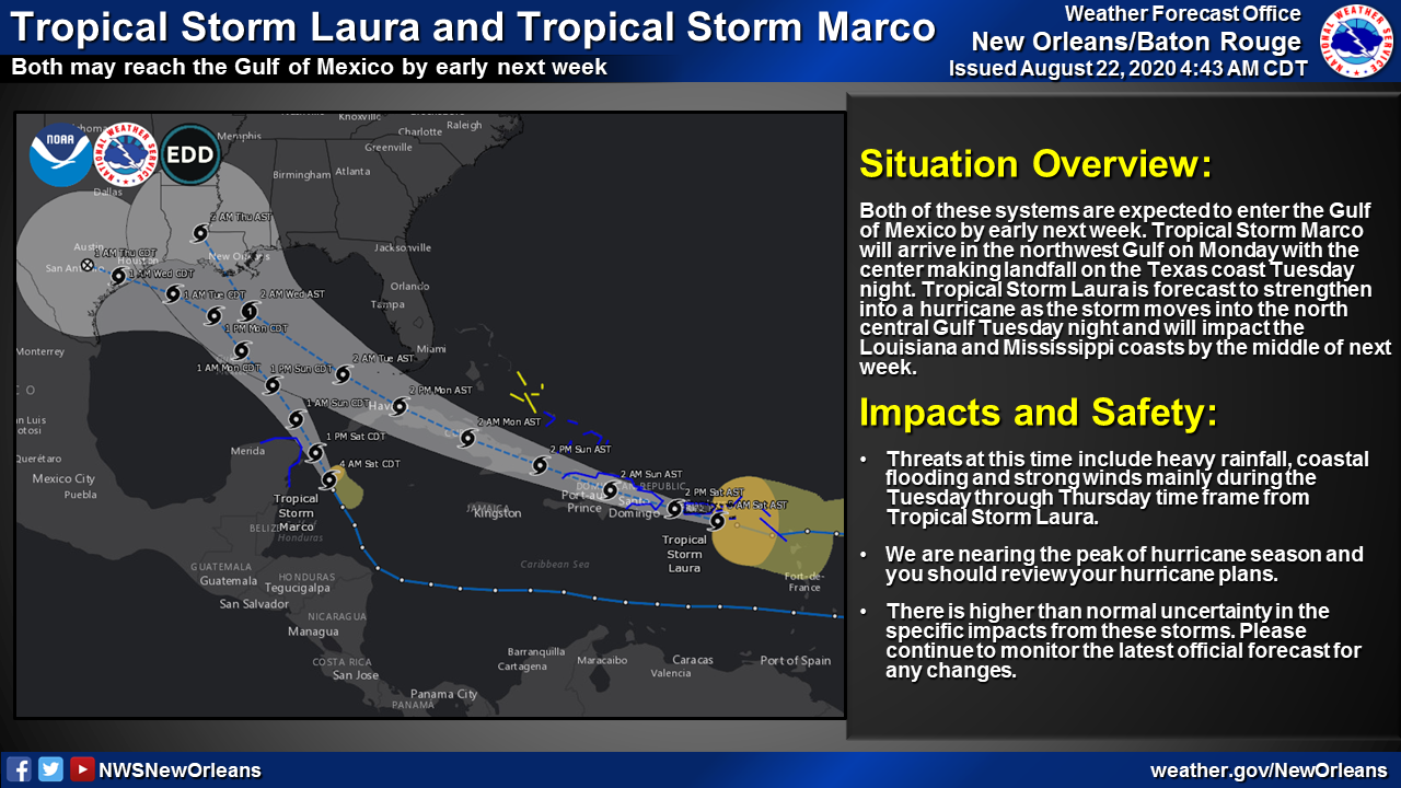
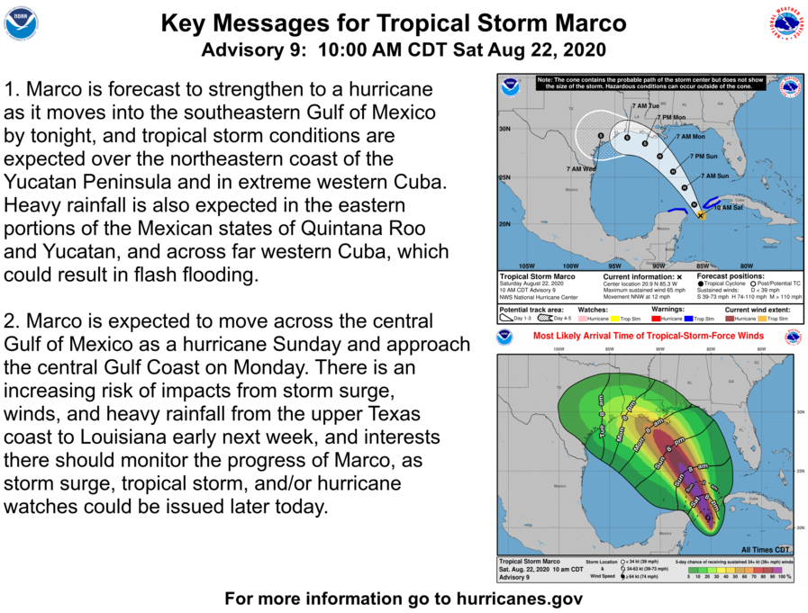
At the 10am advisory, we see Tropical Storm Marco strengthening quickly. It is expected to become a hurricane by tonight. The path of this storm has shifted to the northwest, placing it in a position to strike the Texas coast around Tuesday/Wednesday. Storm surge, tropical storm, and/or hurricane watches could be issued later today.

Tropical Storm Laura’s path remains relatively unchanged from this morning. It is expected to strengthen as it moves over Gulf waters early next week.
Tropical Storm Marco
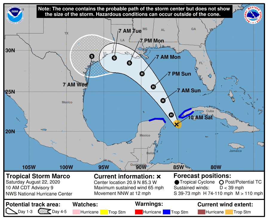 At 10 a.m., CDT, the center of Tropical Storm Marco was located about 105 miles (170 km) east-northeast of Cozumel, Mexico. It’s moving toward the north-northwest near 12 mph (19 km/h), and this general motion is expected to continue through Sunday morning. A gradual turn toward the northwest and west-northwest is expected to begin Sunday afternoon and continue through Tuesday morning. On the forecast track, Marco’s center will move through the Yucatan Channel into the southeastern Gulf of Mexico by this evening, move across the central Gulf of Mexico on Sunday, and approach the central and northwestern Gulf coast on Monday and Tuesday.

Data from the Hurricane Hunter aircraft indicate that maximum sustained winds have increased to near 65 mph (100 km/h) with higher gusts. Tropical-storm-force winds extend outward up to 45 miles (75 km) from the center. Additional strengthening is forecast to occur during the next day or two, and Marco is expected to become a hurricane later today. Weakening is forecast to occur on Monday and Tuesday.
Marco is expected to move across the central Gulf of Mexico as a hurricane Sunday and approach the central Gulf Coast on Monday. There is an increasing risk of impacts from storm surge, winds, and heavy rainfall from the upper Texas coast to Louisiana early next week, and interests there should monitor the progress of Marco, as storm surge, tropical storm, and/or hurricane watches could be issued later today.
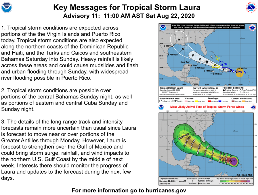
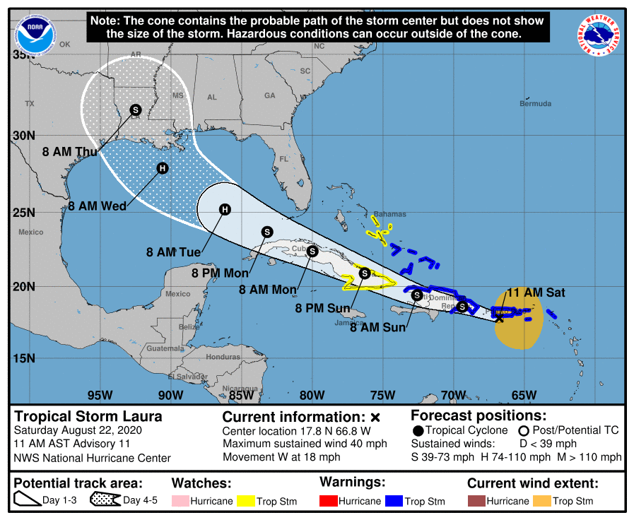 Tropical Storm Laura

At 10 a.m., CDT, the center of Tropical Storm Laura was located over the Atlantic Ocean about 20 miles (30 km) southwest of Ponce, Puerto Rico, and about 210 miles (335 km) east-southeast of Santo Domingo, Dominican Republic. It’s moving toward the west near 18 mph (30 km/h), and a generally west-northwestward motion is expected over the next few days. On the forecast track, the center of Laura will move near Puerto Rico this morning, near or over Hispaniola this afternoon and tonight, and near or over eastern Cuba Sunday and Sunday night.
Maximum sustained winds are near 40 mph (65 km/h) with higher gusts. Tropical-storm-force winds extend outward up to 205 miles (335 km) from the center. A Weatherflow station located at Isla Culebrita recently reported a wind gust to 43 mph (69 km/h). Another Weatherflow station at Sandy Point on the Island of St. Croix recently reported a wind gust to 41 mph (66 km/h). Slow strengthening is expected to occur during the next few days.

