
Terrebonne Parish floodgates scheduled to close throughout the day
September 13, 2020
Mandatory evacuation ordered for Grand Isle
September 13, 2020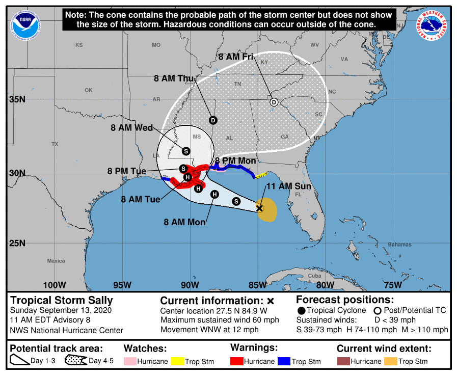
The 10am advisory shows a slight jog to the west, which is not the greatest news for our area. The Hurricane Warning along the coast of Louisiana has been extended westward to Morgan City. A Tropical Storm Warning has been issued for the coast of Louisiana from west of Morgan City to Intracoastal City. TS Sally is still expected make landfall on Tuesday morning as a hurricane.
A Storm Surge Warning is in effect for:
* Port Fourchon Louisiana to the Mississippi/Alabama Border
* Lake Pontchartrain, Lake Maurepas, and Lake Borgne

A Hurricane Warning is in effect for:
* Morgan City Louisiana to Ocean Springs Mississippi
* Lake Pontchartrain and Lake Maurepas including metropolitan New Orleans
A Storm Surge Watch is in effect for:
* Mississippi/Alabama Border to the Alabama/Florida Border
A Hurricane Watch is in effect for:
* East of Ocean Springs to the Alabama/Florida Border

A Tropical Storm Warning is in effect for:
* East of Ocean Springs to Indian Pass
* Intracoastal City Louisiana to west of Morgan City
A Tropical Storm Watch is in effect for:
* Indian Pass to Ochlockonee River Florida
At 1100 AM EDT (1500 UTC), the center of Tropical Storm Sally was located near latitude 27.5 North, longitude 84.9 West. Sally is moving toward the west-northwest near 12 mph (19 km/h), and a west-northwestward or northwestward motion is expected through Monday. A decrease in forward speed and a turn toward the north-northwest is forecast on Monday night, and slow north-northwestward motion is expected Tuesday. On the forecast track, the center of Sally will move over the eastern Gulf of Mexico today, move over the north-central Gulf of Mexico tonight and Monday, and approach the north-central Gulf Coast within the hurricane warning area late Monday and Monday night. Sally is expected to move farther inland over southeastern Louisiana on Tuesday and Tuesday night.

Data from an Air Force Reserve Hurricane Hunter aircraft indicate that the maximum sustained winds have increased to near 60 mph (95 km/h) with higher gusts. Strengthening is expected over the next day or so, and Sally is forecast to become a hurricane on Monday, with some additional strengthening possible before landfall Monday night.
Tropical-storm-force winds extend outward up to 90 miles (150 km) primarily to the east of the center. The latest minimum central pressure estimated from reconnaissance aircraft data is 998 mb (29.48 inches).

