
Few details on ‘Expose Dat’ cop incident
January 26, 2019
Addressing Chronic Pain Amidst a National Opioid Crisis
January 28, 2019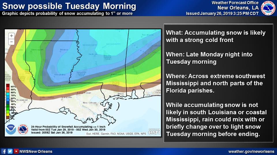
A cold front will sweep through the area on Tuesday and there is a chance that we’ll see snow.

The National Weather Service’s New Orleans Office released a map this weekend, which illustrates the strong possibility for snow accumulation in northern and Central Louisiana late Monday night and into Tuesday morning.
A strong front will approach the area on Tuesday, lowering the temperatures below freezing.
The front will have moisture ahead of it on early Tuesday and the combination of cold temperatures and the precipitation could create snow fall, sleet or wintry mix in the area.

The National Weather Service said the primary threat for snow will be throughout Southwest Mississippi and adjacent Louisiana parishes – throughout central Louisiana and into the northern reaches of the state.
In the map released by the National Weather Service, our area is given a 0 percent chance for snow accumulation, but in the release, forecasters say that “rain could mix with or briefly change over to light snow” on Tuesday morning before ending.
Temperatures will be in the lower 30s and wind chills will be in the 20s.

Pet and plant precautions are urged to locals in lieu of the expected winter weather event.

