
Get a Game Plan: Ready Your Hurricane Kit for 2020
August 21, 2020
TPSO: Two arrested on drug charges on Shrimper’s Row
August 21, 2020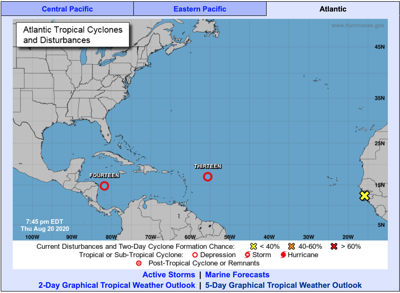
With this morning’s update, the forecast from the National Hurricane Center is now calling for the possibility of having two Category 1 hurricanes in the Gulf at the same time. Right now, both of these systems remain tropical depressions, but will likely become tropical storms sometime today. The last time two named storms were in the Gulf at the same time was 1959.
The next two names up are Laura and Marco.
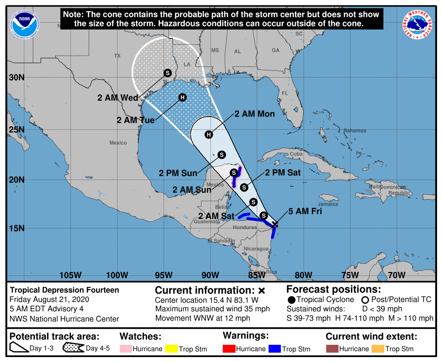
At 5 a.m., EDT, the center of Tropical Depression Fourteen was located over the western Caribbean Sea about 30 miles (45 km) north-northeast of Cabo Gracios A Dios on the Nicaragua / Honduras border. It’s moving toward the west-northwest near 12 mph (19 km/h), and this general motion is forecast to continue this morning.

The system is expected to move into the south-central Gulf of Mexico as a tropical storm on Sunday. Some strengthening is anticipated while it moves northwestward over the western Gulf of Mexico early next week, but it is too soon to know exactly how strong it will get or the location and magnitude of impacts it will produce along the central or northwestern Gulf Coast. Interests in that area should continue monitoring the progress of this system during the next few days.
Maximum sustained winds are near 35 mph (55 km/h) with higher gusts. Strengthening is forecast to take place during the next couple of days, and the depression is expected to become a tropical storm later today. The system is forecast to be near or at hurricane strength when it reaches the Yucatan Peninsula of Mexico late Saturday. Some weakening is expected as it traverses the Yucatan Peninsula Saturday night. Afterward, restrengthening is forecast on Sunday as it moves offshore and enters the southern Gulf of Mexico.
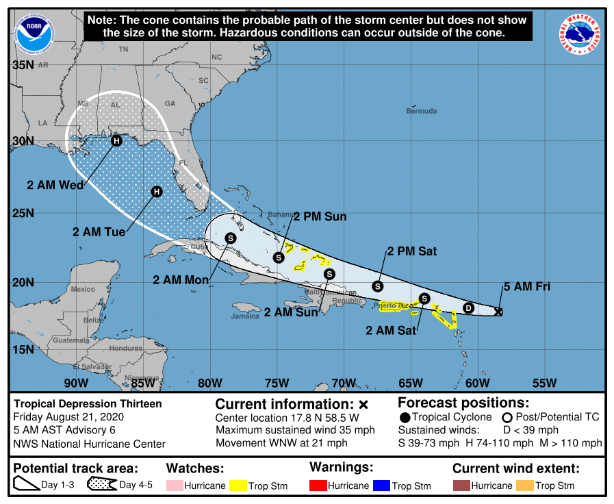
At 5 a.m. AST, the center of Tropical Depression Thirteen was located over the Atlantic Ocean about 305 miles (490 km) east of the northern Leeward Islands. It’s moving toward the west-northwest near 21 mph (33 km/h), and this motion is expected to continue for the next few days. On the forecast track, the depression is expected to move near or north of the northern Leeward Islands later today, near or north of the Virgin Islands and Puerto Rico on Saturday, and near or north of Hispaniola Saturday night.

Maximum sustained winds remain near 35 mph (55 km/h) with higher gusts. Gradual strengthening is forecast to occur, and the depression is likely to become a tropical storm by the weekend.
The details of the long-range track and intensity forecasts are more uncertain than usual since the system could move over portions of the Greater Antilles this weekend. However, this system could bring some storm surge, rainfall and wind impacts to portions of Hispaniola, Cuba, the Bahamas, and Florida this weekend and early next week. Interests there should monitor this system’s progress and updates to the forecast over the next few days.

