
Delta still growing stronger; Category 5 possible before landfall in Mexico
October 6, 2020
Sheriff Soignet announces initial Hurricane Delta preparations
October 6, 2020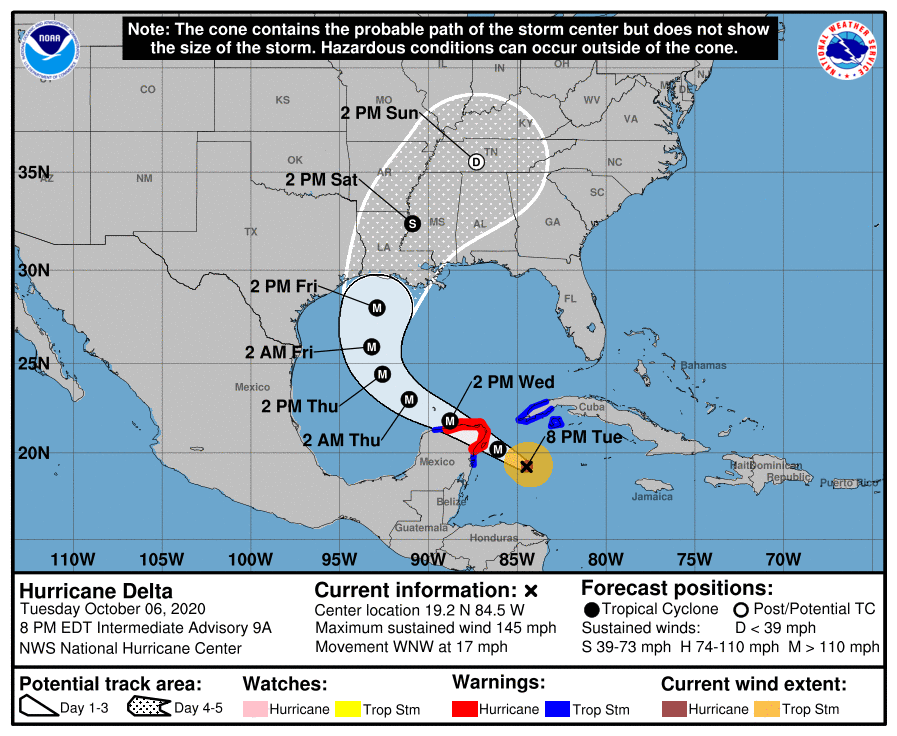
The newest update for Hurricane Delta shows very minor changes. Winds are still at 145 mph and it is moving quickly at 17 mph. The eye is rather small, only at 5-6 nautical miles. Until it makes landfall over Mexico and makes its way into the Gulf, the path will remain very uncertain.
At 8 p.m. EDT, the center of Hurricane Delta was located over the northwest Caribbean Sea about 240 miles (285 km) east-southeast of Tulum, Mexico. Delta is moving toward the west-northwest near 17 mph (28 km/h). A west-northwestward to northwestward motion is expected over the next couple of days. A slower northwestward to north-northwestward motion is forecast to begin on Thursday, and a northward motion is expected Thursday night and Friday. On the forecast track, the center of Delta will move over the northeastern portion of the Yucatan peninsula late tonight or early Wednesday.
Delta is forecast to move over the southern Gulf of Mexico Wednesday afternoon, be over the southern or central Gulf of Mexico through Thursday, and approach the northern Gulf coast on Friday.
Maximum sustained winds are near 145 mph (230 km/h) with higher gusts – a category 4 hurricane on the Saffir-Simpson Hurricane Wind Scale. Hurricane-force winds extend outward up to 30 miles (45 km) from the center and tropical-storm-force winds extend outward up to 105 miles (165 km). Some strengthening is possible before the center reaches the coast of the Yucatan peninsula early Wednesday. Although some weakening is likely when Delta moves over the Yucatan peninsula, re-strengthening is forecast when the hurricane moves over the southern Gulf of Mexico Wednesday night and Thursday.
There is an increasing likelihood of life-threatening storm surge and dangerous hurricane-force winds, especially along the coasts of Louisiana and Mississippi, beginning on Friday. Residents in these areas should ensure they have their hurricane plan in place and follow advice given by local officials. Storm surge and hurricane watches will likely be issued for portions of the northern Gulf Coast on Wednesday.
Delta is expected to produce 4 to 6 inches of rain, with isolated maximum totals of 10 inches, across portions of the northern Yucatan Peninsula through midweek. This rainfall may result in areas of significant flash flooding. During the next few days, Delta is expected to produce 2 to 4 inches of rain, with isolated higher amounts, across portions of the Cayman Islands and western Cuba. This rainfall may result in areas of flash flooding and mudslides.
The next complete advisory will be issued by NHC at 11 p.m. EDT

