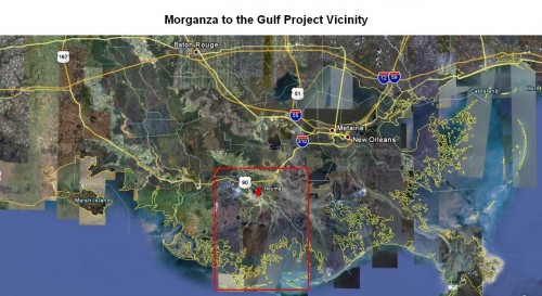
Morganza project dates back 80 years
May 16, 2012Ocean levels could impact Tri-parish levee system
May 16, 2012
Need an example of how what one does today could impact future generations? Look no farther than coastal Louisiana, where the appearance of land loss by encroaching water from the Gulf of Mexico is really evidence of non-replenished property being surrendered to the sea.
A series of four major hurricanes between 2005 and 2008, then the world’s largest oil spill in 2010 brought attention by the rest of the nation to places called Terrebonne and Lafourche.

The sudden contemporary environmental concern suggested that offshore powers and influences were solely to blame for the depletion of 1,883 square miles of Louisiana between 1932 and 2010.

The truth, however, marks the origin of land loss in the Mississippi River delta as beginning years earlier. Evidence also indicates that it was the manipulation of fresh water flows from upstream connections with the 2,350 miles of the mighty waterway and its 250 tributaries started the sinking of Louisiana.
In an article by civil engineer E.L. Corthell for the December 1897 National Geographic magazine – yes, that is 1897 – researchers demonstrated how severe channeling of the Mississippi River from its natural flow not only helped control flooding, but was also robbing the delta area of real estate.

Corthell reported that measurements around New Orleans revealed how Gulf levels appeared to be increasing in comparison to structures of the area. Some people at the time even suggested ocean levels were rising – much as contemporary reports contend global warming, with 20th century industry as the sole culprit, is behind melting polar ice caps and rising ocean levels today.

However, comparative analysis of the Gulf Coast from the Yucatan Peninsula to Florida, found during the final decade of the 19th century that the only changes taking place were in near proximity to the Mississippi River, with no indication of elevation change in any other area.
The cause of a land level drop, according to researchers was not an encroaching sea, but a lack of sediment, which had previously replenished the region for untold amounts of time.

“The level of the Gulf had gone up over one-foot in 12 years,” Corthell said in his report. “It is a fact well known to people living in the delta of the Mississippi that large tracts of land were long ago abandoned in consequence of overflow of Gulf waters, due to the shrinking of the lands.”
Houma attorney and Morganza Action Coalition president Danny Walker confirmed that the presence of subsidence in the region that once saw what is now Bayou Lafourche as mouth of the Mississippi River is nothing new.
Walker said decreased land elevation advanced with continual routing and re-routing of natural flow, even if the intentions were to prevent devastating floods such as occurred during 1927, and covered more than 28,500 square miles of land from Louisiana to Illinois.
“The situation we have could have been prevented,” he said. “We have been partly at fault with cutting canals, but the big part of our land loss has been due to river diversion.”
Walker, like many environmental and industrial leaders contends that marshland in areas like Terrebonne and Lafourche parishes will never be restored to their original form, but could be protected from further loss if the federal government were to assist locals in funding a comprehensive plan.
“We just don’t have the power in Washington,” Walker said. “Historically, we have not had the clout. We don’t have the votes or population to get what we need – fresh water diversion.”
According to the Coastal Protection and Restoration Authority of Louisiana, the state suffers from 90 percent more land loss than any of the remaining lower 48 states. During the time between hurricanes Katrina and Ike, 328 square miles of coastal Louisiana marshland turned to open water, and most recent land loss measurements are described as being the dimension of a football field disappearing every hour.
Corthell reported more than 114 years ago that Louisiana was losing three square miles of land sediment per day. A warning about practices of that time and suggestions of what the consequences might be was given.