
Car crashes into Dominique’s Bistro on Main Street
June 2, 2022
Entergy Providing $1 Million to Help Jumpstart LCTCS Implementation of MJ Foster Promise Program
June 2, 2022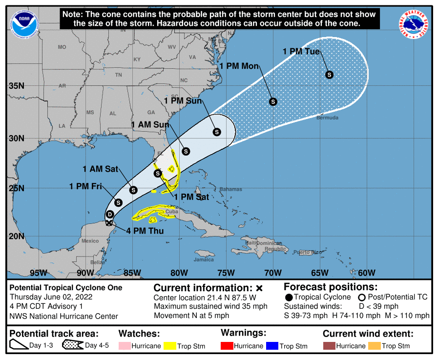
We are on our way to our first named storm in the 2022 Hurricane Season. The first name on the list is Alex. At this time, the potential storm poses no threat to Louisiana.
At 400 PM CDT (2100 UTC), the disturbance was centered near latitude 21.4 North, longitude 87.5 West. The system is moving toward the north near 5 mph (7 km/h) and this motion is expected to continue tonight. A turn toward the northeast is expected on Friday, and a faster motion toward the northeast is expected Friday night and Saturday. On the forecast track, the system should move across the southeastern Gulf of Mexico through Friday night, and then move across the southern and central portions of the Florida Peninsula on Saturday.

Maximum sustained winds are near 35 mph (55 km/h) with higher gusts. The system is expected to become a tropical depression on Friday and a tropical storm late Friday or Friday night. The Formation chance through 48 hours is high…90 percent. Formation chance through 5 days is high…90 percent.
The estimated minimum central pressure is 1003 mb (29.62 inches).
A Tropical Storm Watch has been issued for the west coast of the Florida peninsula south of the Middle of Longboat Key and for the east coast of the Florida peninsula south of the Volusia/Brevard County line, including Lake Okeechobee.

A Tropical Storm Watch has been issued for all of the Florida Keys, including the Dry Tortugas and Florida Bay.
The government of Cuba has issued a Tropical Storm Watch for the Cuban provinces of Matanzas, Mayabeque, La Habana, Artemisa, and Pinar del Rio, and the Isle of Youth.

