
Sign up today for the Bayou Culture Collaborative August Gathering
August 20, 2023
Tanner Magee reflects on his 8 years as State Representative
August 20, 2023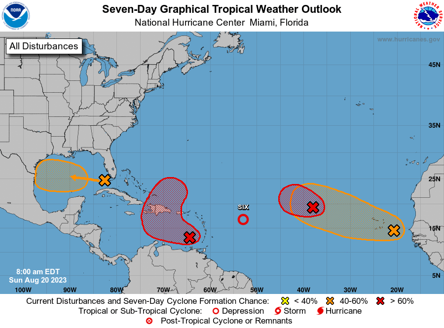
NWS National Hurricane Center Miami FL
800 AM EDT Sun Aug 20 2023
For the North Atlantic…Caribbean Sea and the Gulf of Mexico:

1. Central Tropical Atlantic (AL98):
Showers and thunderstorms continue to show signs of organization in association with an area of low pressure located several hundred miles west-northwest of the Cabo Verde Islands. Earlier satellite wind data indicated the system was producing winds up to 40 mph on its north side. In addition, first light visible satellite suggests the center may be becoming better defined. If these current trends continue, a short-lived tropical depression or tropical storm is likely to form later today or tonight while it moves west-northwestward at about 10 mph over the central tropical Atlantic. By Monday, upper-level winds are forecast to strengthen over the system, and further development is not expected. For additional information on this system, including gale warnings, see High Seas Forecasts issued by the National Weather Service.
* Formation chance through 48 hours…high…80 percent.
* Formation chance through 7 days…high…80 percent.
2. Eastern Caribbean (AL90):
Showers and thunderstorms continue to show signs of organization in association with an area of low pressure over the far eastern Caribbean Sea. Additional development of this system is expected, and a tropical depression is likely to form during the next couple of days as it moves westward to west-northwestward at 10 to 15 mph over the eastern and central Caribbean, before turning northward and moving into the southwestern Atlantic Ocean by midweek. Regardless of development, heavy rainfall is possible over portions of the Lesser Antilles during the next couple of days. Interests in the eastern and central Caribbean should monitor the progress of this system. A NOAA Hurricane Reconnaissance mission is scheduled to investigate the system later today.
* Formation chance through 48 hours…high…70 percent.
* Formation chance through 7 days…high…80 percent.
3. Western Gulf of Mexico:
An area of disturbed weather located in the far eastern Gulf of Mexico is expected to lead to the formation of a broad area of low pressure early this week. Some slow development of this system could occur thereafter as it moves westward at about 15 to 20 mph, and a tropical depression could form as it approaches the western Gulf of Mexico coastline by Tuesday.
* Formation chance through 48 hours…low…30 percent.
* Formation chance through 7 days…medium…50 percent.

4. Eastern Tropical Atlantic:
A large area of disorganized showers and thunderstorms over the far eastern tropical Atlantic is associated with a tropical wave. Environmental conditions appear conducive for gradual development of this system, and a tropical depression could form later this week while it moves west-northwestward across the eastern tropical Atlantic.
* Formation chance through 48 hours…low…10 percent.
* Formation chance through 7 days…medium…50 percent.
Active Systems:
The National Hurricane Center is issuing advisories on Tropical Depression Six, located several hundred miles east of the northern Leeward Islands.
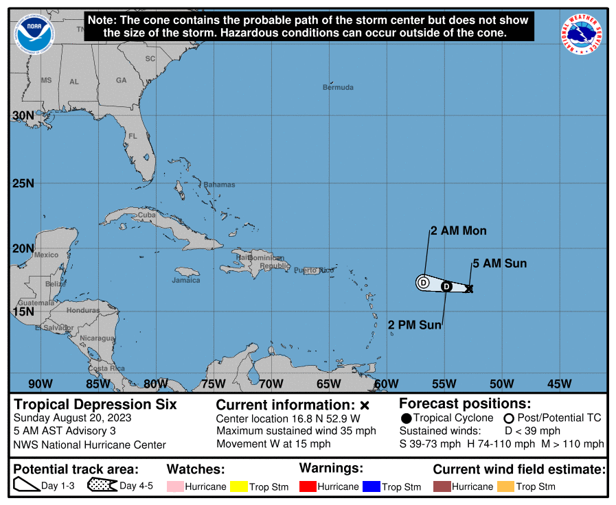
At 500 AM AST (0900 UTC), the center of Tropical Depression Six was located near latitude 16.8 North, longitude 52.9 West. The depression is moving toward the west near 15 mph (24 km/h), and this general motion is expected to continue for the next day or so.

Maximum sustained winds are near 35 mph (55 km/h) with higher gusts. Some gradual weakening is expected, and the depression is forecast to become a remnant low early Monday and dissipate soon thereafter.
The estimated minimum central pressure is 1007 mb (29.74 inches).

