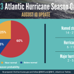
NOAA releases updated 2023 Atlantic hurricane season outlook
August 17, 2023
Gov. Edwards Holds Unified Command Group Meeting as State Grapples with Heat, Enters the Heart of Hurricane Season
August 18, 2023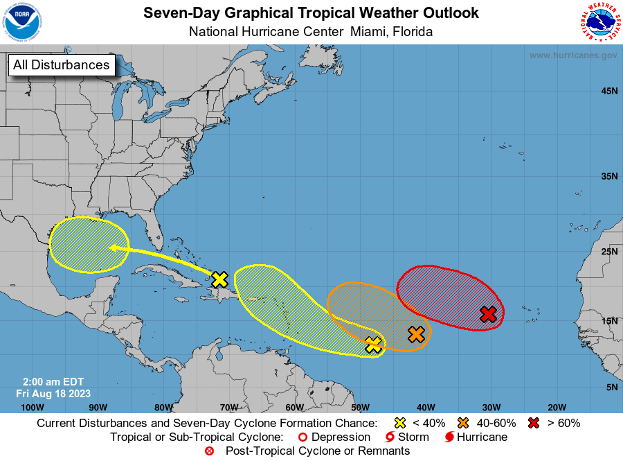
For the North Atlantic…Caribbean Sea and the Gulf of Mexico:
1. Eastern Tropical Atlantic (AL98):
Showers and thunderstorms continue to show some signs of organization in association with a broad area of low pressure located a few hundred miles west of the Cabo Verde Islands. Environmental conditions appear generally favorable for additional development of this system, and a tropical depression is likely to form over the weekend while it moves toward the west-northwest or northwest at about 10 mph across the eastern tropical Atlantic. By early next week, upper-level winds over the system are forecast to increase, and further development is not expected.
* Formation chance through 48 hours…medium…50 percent.
* Formation chance through 7 days…high…70 percent.
2. Central Tropical Atlantic (AL99):
An elongated trough of low pressure located more than 1000 miles west-southwest of the Cabo Verde Islands is producing some disorganized showers and thunderstorms. Environmental conditions are only marginally conducive for further development of this system, but a tropical depression could still form during the next couple of days while it moves west-northwestward at 10 to 15 mph across the central tropical Atlantic. Thereafter, upper-level winds are
forecast to become unfavorable for any further development.
* Formation chance through 48 hours…medium…40 percent.
* Formation chance through 7 days…medium…40 percent.

3. East-Southeast of the Lesser Antilles:
Another area of low pressure could form in a day or so from an elongated trough of low pressure located several hundred miles to the east-southeast of the Lesser Antilles. Some slow development of this system is possible over the weekend and into early next week as it moves generally west-northwestward at 10 to 15 mph across the Lesser Antilles and into the northeastern Caribbean Sea.
* Formation chance through 48 hours…low…10 percent.
* Formation chance through 7 days…low…20 percent.
4. Western Gulf of Mexico:
An area of disturbed weather located just north of Hispaniola is forecast to move into the Gulf of Mexico by early next week, where a broad area of low pressure could form. Some slow development of this system is possible thereafter as it moves westward and approaches the western Gulf of Mexico coastline by the middle of next week.
* Formation chance through 48 hours…low…near 0 percent.
* Formation chance through 7 days…low…30 percent.

