
Edna Stewart
March 15, 2011
Is Our Seafood Safe?
March 17, 2011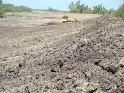
After more than two years of protests, the Federal Emergency Management Agency relented and announced Thursday it will discontinue a policy that ignored unaccredited levees as they pertained to flood maps.
The policy, nicknamed “without levee”, takes into account roads, sand dunes, railroad lines, accredited levees and other water-impeding structures in determining new-structure elevation limits, but does not acknowledge the mere existence of levees that did not meet U.S. Army Corps of Engineers height and durability standards.

The exact details of the new approach have yet to be conceived, but the agency will withhold elevation directives for communities that contain unaccredited levees that, when included, would “more accurately reflect the flood risk,” FEMA Spokeswoman Rachel Racusen said.

“It is going to allow FEMA’s maps to reflect reality,” said Windell Curole, general manager of South Lafourche Levee District. “The computer models that we were using and the policies we were using did not reflect reality.
“Our goal is not to minimize the flood risk or maximize it. We just want it to reflect reality so people can go on with their lives and plan properly, so [FEMA] looking at accepting what is real is nothing but a plus.”

Last month, 27 U.S. senators and 49 members of Congress sent a letter to FEMA Administrator Craig Fugate that asked him to consider all means of flood protection when developing flood maps.

Curole, Lafourche Parish President Charlotte Randolph and North Lafourche Levee District Executive Director Dwayne Bourgeois debated in favor of the policy change for more than two years.
“This was a major victory for our community today,” Randolph said. “We’ve been fighting to get FEMA to recognize the South Lafourche Levee System because we know we have an effective system, and they were treating it like it didn’t exist.”
Although South Lafourche levees have yet to breach, Curole said SLLD was the first levee system to be decertified when the Corps of Engineers imposed stricter standards after Hurricane Katrina five and a half years ago.
FEMA’s flood maps, by not including the South Lafourche levees in computer model predictions, would have ordered that new structures built inside the levee system had to meet the same elevation requirement as new structures outside of the system.
Curole said that FEMA’s computer model showed 14 feet of flooding inside the levee system. He said SLLD ran the exact model, but included the levees and it showed only one foot of water inside the system.
The current elevation requirements are three and a half feet. Curole said he hopes FEMA uses the same model as SLLD, which would keep the elevation requirements stable. Randolph said she wouldn’t be opposed to FEMA imposing a six-foot requirement.
“Anyone who wants to invest inside the system now will feel more secure about doing so because the levee does exist,” Randolph said. “They may have to build a little bit higher, but that’s OK. We live on the coast.”
Flood insurance premiums are grandfathered, meaning existing structures that were built to current minimum elevation requirements would not be subject to increased rates.
“The only difference is that if you didn’t insure your house and the new elevations came in, then if you tried to get insurance, you would be penalized for every foot you were below 14 feet,” Curole said.
The maps also would impact structures that flooded at more than 50 percent of their value. In that scenario, the buildings would have to be constructed to the FEMA-directed elevation.
Randolph said the next battle would be ensuring the premiums are not increased due to the conception that the South Lafourche levees are substandard.
“I’m hoping that they’re not going to say, ‘We’ll include it but you’ll have to pay higher insurance because you don’t have the perfect system here,’” the parish president said. “That’s unacceptable because many people have had their insurance go up because of the storms that have gone through here, and yet, the system has held up. It’s the only system in this area that has held up completely.”
FEMA officials said the change in policy was driven through correspondence with lawmakers and other stakeholders.
“We have determined that an improved approach will enable FEMA to provide maps that more accurately reflect the flood risk experienced by families living behind levees, but it will take us some time to finalize a new approach,” Racusen said. “In the meantime, FEMA is withholding finalizing flood maps for communities with levees who could be impacted by a new approach that more closely reflects the flood risk in their area.”
Curole said SLLD will continue to build levees to their own standards, and once that is done they will start allocating resources to meet the more-expensive Corps requirements.
“We will do what we’ve been doing ever since I started back in 1980,” Curole said. “We, today, try to have a better flood protection than we had yesterday and tomorrow, have a better flood protection than we had today. That has never changed, and we have continued to improve the flood protection.”
FEMA announced last week they would withhold ‘without levee’ computer model analysis, a policy that ignores substandard levees in flood projections. The change in policy directly impacts the South Lafourche Levee District, whose levees are not up to federal standards but have yet to allow water into the levee system. COURTESY PHOTO
