
TPSO: Man arrested on multiple charges following pursuit
March 22, 2021
HPD Investigating Homicide of 8-year-old Girl
March 23, 2021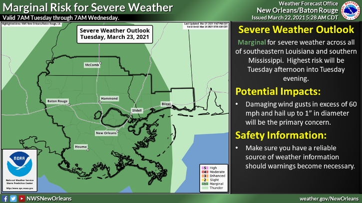
Due to the expected inclement weather, the National Weather Service in New Orleans has issued a flash flood watch for Terrebonne and Lafourche in effect from Tuesday morning through Thursday evening.

This includes the areas of Chauvin, Cocodrie, Dulac, Montegut, Galliano, Cut Off, Golden Meadow and
and Leeville.
Here is the NWS New Orleans update concerning the heavy rain and severe thunderstorm threat from Tuesday through Thursday:
These storms have the potential to produce efficient rainfall/high rainfall rates and rainfall rates inside heaviest thunderstorms could be 2″ or higher/hour.

River forecasts take into account 48 hour rainfall totals, so currently do not include rainfall after Wednesday morning. We will have a better idea of the river rises due to the event total rainfall tomorrow afternoon.
We are including the day-by-day forecasted rainfall below in the slides along with the event total rainfall as we promised in the briefing call. Locally higher amounts are definitely possible.
WHAT:
MARGINAL to SLIGHT RISK
of Heavy Rain
MARGINAL to
SLIGHT RISK
of Severe Thunderstorms
WHEN: The heavy rain threat
will be highest from Tuesday afternoon through Thursday afternoon.
The first severe thunderstorm threat will be from Tuesday midday through Tuesday evening.
The second severe thunderstorm threat will be from Wednesday afternoon through Thursday evening.
WHERE: The risk of heavy
rainfall that could produce flooding issues and severe thunderstorms will exist across all of southern MS and southeast LA.
CONFIDENCE:
We are confident that there will be thunderstorms across the area and that a few will produce heavy rainfall and severe weather impacts.

Rainfall of 4 to 8 inches is currently forecast. Locally higher amounts will be possible.
Expect ponding of water in low lying areas and some potential for localized flash flooding.
As water drains into area rivers, minor to moderate flooding could develop.
Damaging winds in excess of 60 mph, hail, and a few tornadoes will be possible with any severe storms.

