Laf. detention center could be refurbished
August 9, 2011New Orleans Museum of Art (New Orleans)
August 15, 2011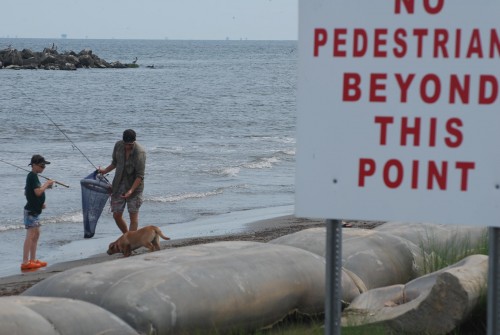
The U.S. Army Corps of Engineers is hoping to make its recommendation to Congress as to whether or not it will acquire Fourchon Beach property by December, representatives with the corps said last week.

The potential property acquisition would be a part of the Barataria Basin Barrier Shoreline (BBBS) Restoration project. If acquired, it would likely be done so in the state’s name, which would permit public access.

“Hopefully this will be decided before the report is final,” said Fay Lachney, a BBBS project manager. “But if that is the case, that will mean this decision will need to be made soon. We’re hoping to have the final report for public review in December, so it would be before that.”
Edward Wisner Donation owns about eight miles of the nine-mile long beach and the Caillouet Land Corporation owns smaller parcels of land on either side of a parish highway that disappears into the Gulf of Mexico.
The Wisner Donation, however, is prohibited from selling its land by an anti-alienation clause included in the property acquisition agreement in 1914, according to Cathy Norman, secretary, treasurer and land manager with Wisner.

“We’re prohibited from selling our property under our original donation agreement,” Norman said.
A contentious issue in recent weeks, the debate hinges on land rights of and public access to Fourchon Beach.
It was reignited when the federal government announced it would move forward with studying the $446 million restoration project, which will fortify nine miles of the Caminada Headland with new sand in an area that can be reached via dry land through Lafourche Parish.

In the meantime, the state is slated to begin a $70 million portion of the restoration project next year.
Lingering contamination from the oil spill, as asserted by Norman and the donation’s property inspector, has the Wisner Donation wary about the state commencing the restoration project before cleanup activity concludes.

The Wisner Donation filed suit against BP for contamination and response costs.

“We want our property returned to what it was,” Norman said. “They have removed a tremendous amount of sediment from our beach. Aside from that, the digging has caused excessive erosion and there is still contamination.”
Representatives with the South Lafourche Beachfront Development District, which has negotiated with both landowners for the right to public access, say its efforts have been continually rebuffed.
The public access point is twofold, including vehicular and pedestrian traffic. The Greater Lafourche Port Commission had an agreement with Wisner that allowed vehicular access, but it was not renewed and Lafourche Parish Government balked at Wisner’s access agreement demands last year prior to the oil spill.

Without an agreement, which typically includes held-harmless insurance clauses, stipulations on trash pickup, beach patrol and lifeguards, Norman said, the public does not have access to the private property.
Wisner did not deny pedestrian access to the beach until the BP Deepwater Horizon oil spill last year, and it continues to block access because cleanup continues and visiting the beach is “dangerous,” Norman said.
“[Cleanup crews] used these metal stakes, and they put them out on the beach to hold the snare and hold the boom, and we’re finding them buried everywhere,” she said. “We just feel there is a lot of hazards on the beach, and we’re not willing to allow someone to go out there and get hurt.”
The corps listened to public comments from Lafourche residents Thursday. In order to bring in equipment and restore the Caminada shoreline the corps must either acquire the land in the name of the state or work out servitude agreements with the two landowners, Lachney said.
“Fourchon Beach is a diamond in the rough,” said Ricky Cheramie, chairman of the Beachfront Commission. “If we polish it and market it, it can become an economic engine for this parish.”
Cheramie’s son, Nick, owns an RV park near the beach.
The beachfront development commission passed a resolution requesting the corps to make an attempt to acquire the property.
“It will be a very difficult process getting the people on the beach once this big beautiful area is opened,” Cheramie said. “If we could get y’all to consider the acquisition of the property through, whether it be the state or the corps or the federal government, that’s all that we’re going to ask that y’all do for us.”
“It’s not the object of a beach,” said Greg Sanamo, of Larose. “We’re not making a beach. We’re making protection, we’re making the estuaries better, we’re bringing in land. I don’t consider it a beach. I would love to be able to use it, but I need to know where those boundaries are.”
“I want to protect the landowners’ rights as far as their royalties are concerned, but we’re going to have to continuously improve on this system for the decades to come,” state Rep. Jerry “Truck” Gisclar said. “I think the state needs to own this property versus allowing the landowners to have this big improvement at taxpayers’ expense.”
Under the current situation, beachgoers can park their vehicles at the end of the parish road and walk down the length of the beach, as long as they remain on state-owned land.
But the boundary over public and private property is muddled. Devastated by years of erosion, the shoreline is presently jutted and the extent of public space is constantly contested.
State law designates as public domain the shoreline up to the mean high-water mark during the winter months. Coastal erosion and the zigzagged shoreline convolute the public ownership area across the beach.
“I was out there with a surveyor one day,” Cheramie said. “It depended on the slope of the beach. Some places you had 10 yards of beach, some 60, some closer to 80 or 90, but in six hours, that could all change.”
Norman said elevation doesn’t factor into the equation and average winter high-tide line does not reach the summertime shoreline.
“It is the mean high-tide mark during the winter months, which in the summer, it is out in the water,” Norman said. “That changes every year. You can’t set a boundary when you’re losing 46 feet a year of beach. We’re losing this property. The public is not losing this property.”
The public still maintains the right to the shoreline, Norman conceded, but in order to reach the absolute Gulf coast, pedestrians must cross private property or climb down a slope topped with boudin bags.
“If people can get down – which they can’t without crossing our property – if they can get down to the water’s edge and walk along the water’s edge, they can do that all they want,” Norman said. “They can go out and fish, walk along the water’s edge. But you can’t bring a camper, you can’t set up chairs without having an agreement with us. To me, that’s perfectly clear.”
The corps said it has no stance on the recreational aspect of the project.
At one time, Lachney said, the corps considered incorporating a parking lot into the plans for beachgoers, but the federal entity could not define a restoration benefit.
Cheramie said the beachfront commission is having the Caillouet land apprised and plans to make an offer to purchase the property.