Nicholls postpones Homecoming activities, pushes classes to virtual format
October 7, 2020
Diocese cancels in-person class for Central Catholic; Other schools will decide tomorrow
October 7, 2020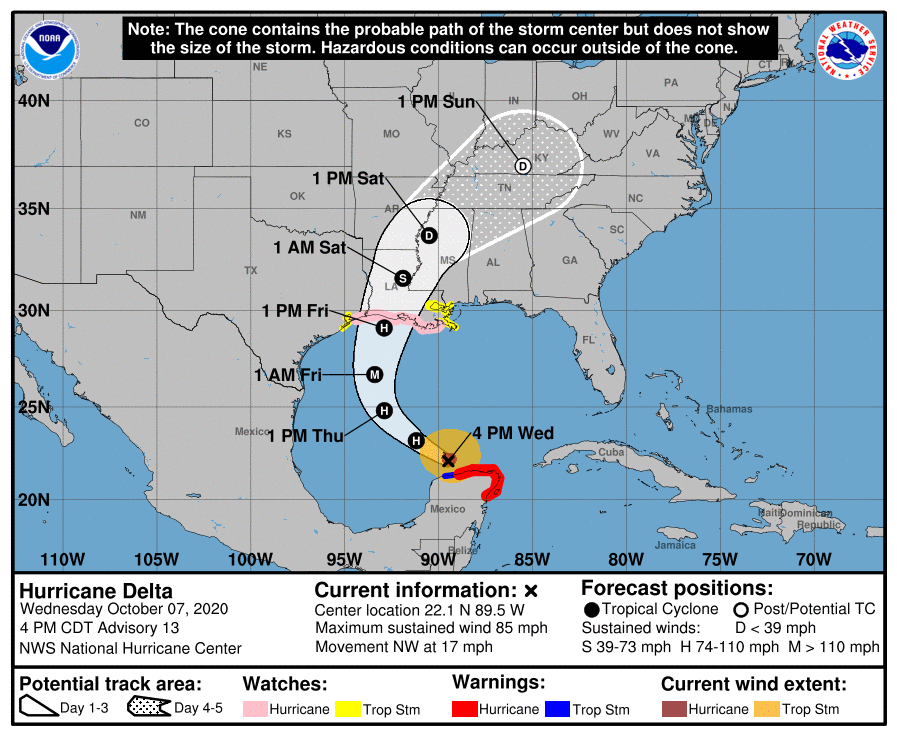
The 4 p.m. update shows Hurricane Delta has weakened to a category 1 storm, with max wind speeds of 85 mph. The forecast still shows the storm gaining strength back to a category 3 over open waters, before making landfall back at a category 2 on Friday afternoon, around 1 p.m. Landfall now projected in Vermilion Parish near Lake Arthur/Gueydan/Kaplan. (This is a low-medium confidence level; the track will continue to shift as the storm approaches. Stay alert!) No changes have been made to watches.
At 4 p.m. CDT, the center of Hurricane Delta was located about 55 miles (90 km) north-northeast of Progreso, Mexico, and about 580 miles (935 km) south-southeast of Cameron, Louisana. Delta is moving toward the northwest near 17 mph (28 km/h). On the forecast track, the center of Delta will move over the southern and central Gulf of Mexico through Thursday, and approach the northern Gulf coast within the hurricane watch area on Friday. Delta is forecast to move inland within the hurricane watch area by late Friday or Friday night.
Data from an Air Force Reserve Hurricane Hunter aircraft indicate that the maximum sustained winds are near 85 mph (140 km/h) with higher gusts. Hurricane-force winds extend outward up to 35 miles (55 km) from the center and tropical-storm-force winds extend outward up to 125 miles (205 km).
Re-strengthening is forecast when the hurricane moves over the southern and central Gulf of Mexico through Thursday, and Delta is expected to become a major hurricane again. Some weakening is forecast as Delta approaches the northern Gulf coast on Friday.
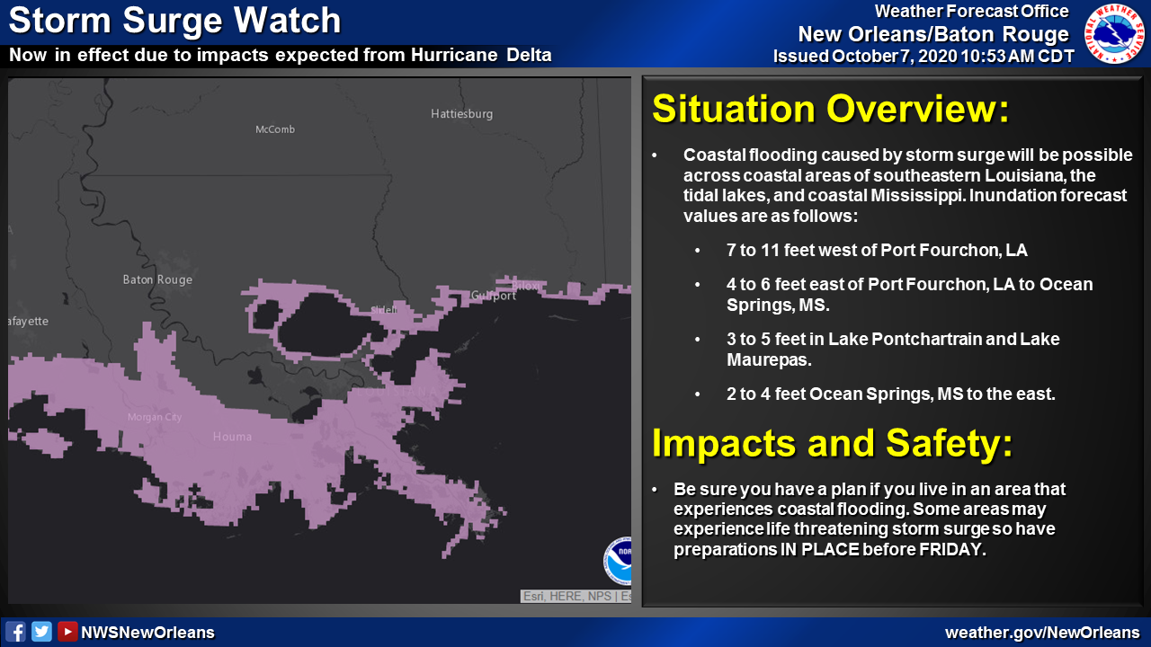
The combination of a dangerous storm surge and the tide will cause normally dry areas near the coast to be flooded by rising waters moving inland from the shoreline. The water could reach the following heights above ground somewhere in the indicated areas if the peak surge occurs at the time of high tide…
– Pecan Island, LA to Port Fourchon, LA including Vermilion Bay…7-11 ft
– Cameron, LA to Pecan Island, LA…4-7 ft
– Port Fourchon, LA to Ocean Springs, MS including Lake Borgne…4-6 ft
– Lake Pontchartrain and Lake Maurepas…3-5 ft
– Ocean Springs, MS to AL/FL state line incl. Mobile Bay…2-4 ft
– High Island, TX to Cameron, LA incl. Calcasieu Lake…2-4 ft
– Sabine Lake…1-3 ft
– Port O’Connor, TX to High Island, TX incl. Galveston Bay…1-3 ft
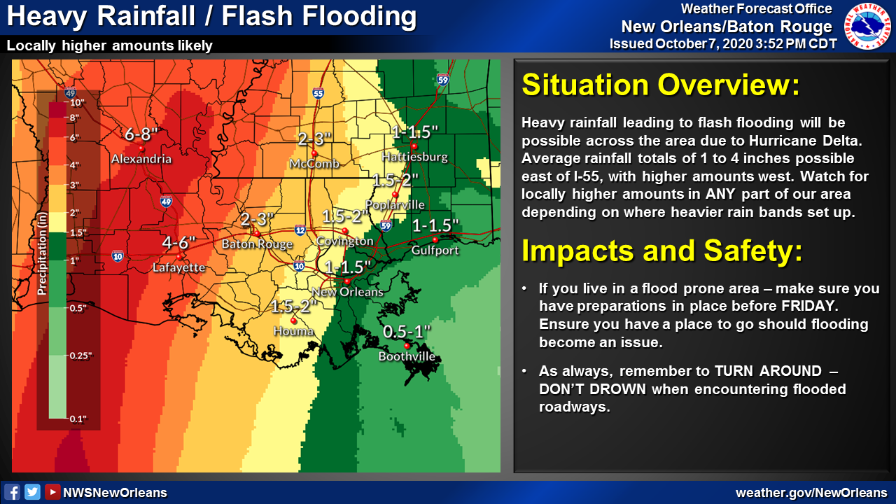
On Friday through Saturday, Delta is expected to produce 4 to 8 inches of rain, with isolated maximum totals of 12 inches across portions of the central Gulf Coast north into portions of the Lower to Middle Mississippi Valley. These rainfall amounts will lead to flash, urban, small stream and minor to isolated moderate river flooding. As Delta moves farther inland, 1 to 3 inches of rain, with locally higher amounts, is expected in the Ohio Valley and Mid Atlantic this weekend.
The risk of a few tornadoes will increase late Thursday night into Friday over portions of southern Louisiana, southern Mississippi, and southwest Alabama.
The next complete advisory will be issued by NHC at 10 p.m. CDT with an intermediate advisory at 7 p.m. CDT

