Cajun Navy Ground Force planning to respond in Houma when storm clears
August 28, 2021
Terrebonne Evacuation Pickup Point to close at 6pm
August 28, 2021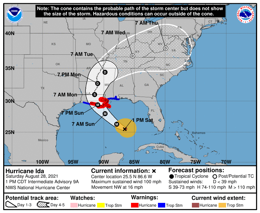
At the 1pm update, Hurricane Ida now a Category 2 storm with winds at 100 MPH. It is moving northwest at 16 MPH.
At 100 PM CDT (1800 UTC), the eye of Hurricane Ida was located near latitude 25.5 North, longitude 86.6 West. Ida is moving toward the northwest near 16 mph (26 km/h), and this general motion should continue through late Sunday or early Monday, followed by a slower
northward motion on Monday. A northeastward turn is forecast by Monday night. On the forecast track, the center of Ida will move over the southeastern and central Gulf of Mexico through tonight. Ida is then expected to make landfall along the coast of Louisiana within the hurricane warning area on Sunday, and then move inland over portions of Louisiana and western Mississippi later on Monday.
Satellite imagery indicates that maximum sustained winds have increased to near 100 mph (155 km/h) with higher gusts. Additional rapid strengthening is forecast during the next 24 hours and Ida is expected to be an extremely dangerous major hurricane when it approaches the northern Gulf coast on Sunday. Weakening is expected after Ida makes landfall.

Hurricane-force winds extend outward up to 30 miles (45 km) from the center and tropical-storm-force winds extend outward up to 125 miles (205 km). NOAA buoy 42003 located about 55 miles (90 km) northeast of the eye has reported peak sustained winds of 52 mph
(83 km/h) with a gust to 62 mph (100 km/h) within the past couple of hours.
The estimated minimum central pressure is 976 mb (28.82 inches).

