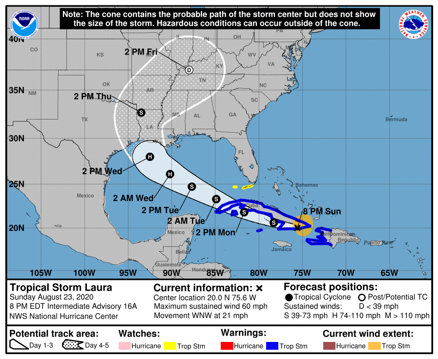
Laura still aims for US coast, closer to Texas/Louisiana border on Wednesday
August 23, 2020
GLPC enters Phase 5, Storm in Port at Port Fourchon
August 23, 2020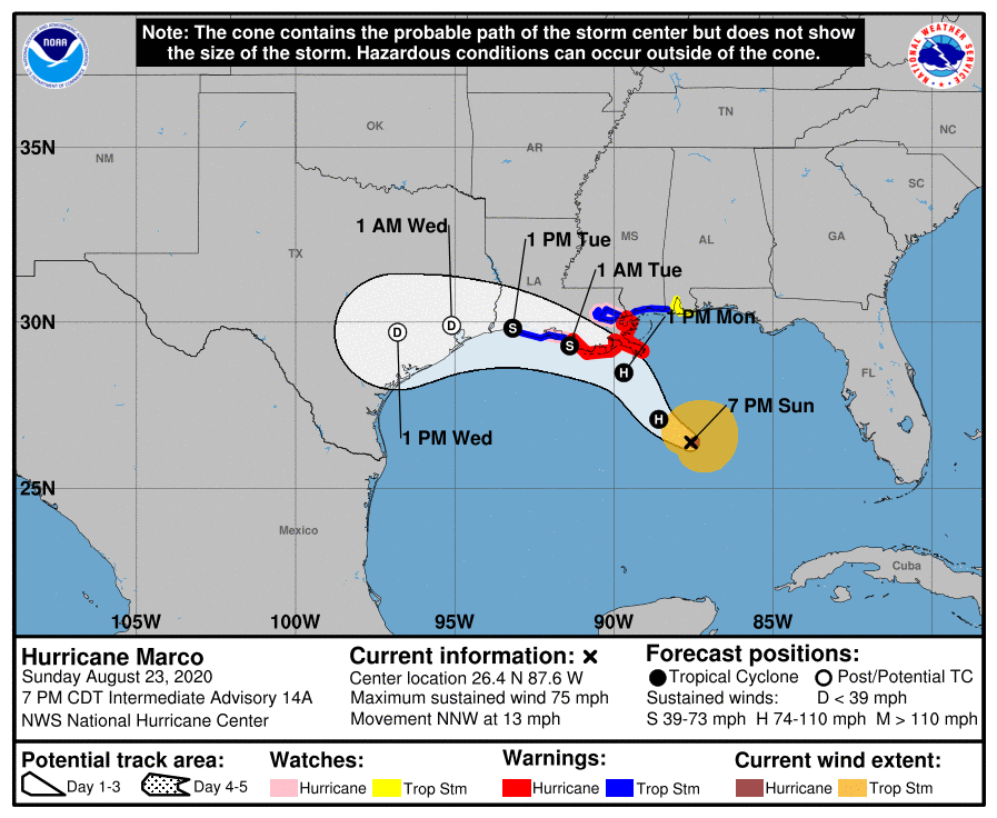
Hurricane Marco seems to shift a little bit more with each update. The 7pm update shows Marco hugging the coast tightly, taking a full 24-hours to make its way across Louisiana. Storm surge remains a serious concern.
At 7 p.m. CDT, the center of Hurricane Marco was located about 240 miles (390 km) south-southeast of the mouth of the Mississippi River. It’s moving toward the north-northwest near 13 mph (20 km/h). Marco is forecast to move generally north-northwestward to northwestward tonight and approach the Louisiana coast Monday afternoon, then turn westward and move near or over the coast through Tuesday.

Maximum sustained winds are near 75 mph (120 km/h) with higher gusts – a category 1 hurricane on the Saffir-Simpson Hurricane Wind Scale. Hurricane-force winds extend outward up to 15 miles (30 km) from the center and tropical-storm-force winds extend outward up to 105 miles (165 km). Small fluctuations in strength are possible tonight. Gradual weakening is expected to begin on Monday, and Marco could become a remnant low by Tuesday night.
The combination of a dangerous storm surge and the tide will cause normally dry areas near the coast to be flooded by rising waters moving inland from the shoreline. The water could reach the following heights above ground somewhere in the indicated areas if the peak surge occurs at the time of high tide…
– Morgan City LA to Mouth of the Mississippi River…4-6 ft
Mouth of the Mississippi River to Ocean Springs MS incl. Lake Borgne…3-5 ft
– Lake Pontchartrain and Lake Maurepas…2-4 ft
– Intracoastal City LA to Morgan City LA…2-4 ft
Sabine Pass to Intracoastal City…1-3 ft
– Ocean Springs MS to the AL/FL state line including Mobile Bay…1-3 ft

Marco is expected to produce total rainfall accumulations of 3 to 5 inches with isolated maximum amounts of 7 inches across the Central U.S. Gulf coast through Tuesday.This rainfall may result in scattered areas of flash and urban flooding along the Central U.S. Gulf Coast.
An isolated tornado is possible early Monday morning near the southeast Louisiana coast. Isolated tornadoes are possible across southeast Louisiana, southern Mississippi, southern Alabama, and the Florida Panhandle Monday and Monday night.

