
Lafourche Parish Shelters open at noon on Saturday; Here’s what you Need to Know
August 27, 2021
Get a Game Plan: Evacuation Plans
August 27, 2021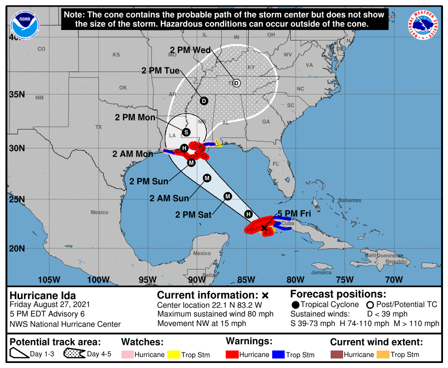
The 4 PM update shows Hurricane Ida striking the Louisiana coast somewhere between Morgan City and Houma, potentially at a Category 4, with wind speeds of 140mph. Impacts will be felt Sunday afternoon into the night.

A Hurricane Warning has been issued for the coast of Louisiana from Intracoastal City to the Mouth of the Pearl River.
At 500 PM EDT (2100 UTC), the center of Hurricane Ida was located near latitude 22.1 North, longitude 83.2 West. Ida is moving toward the northwest near 15 mph (24 km/h), and this general motion should continue until Ida reaches the northern Gulf coast on Sunday. A slower northward motion is forecast after Ida reaches the northern Gulf coast. On the forecast track, the center of Ida will pass over western Cuba during the next several hours, and then move over the southeastern and central Gulf of Mexico later tonight and Saturday. Ida is forecast to make landfall along the U.S. northern Gulf coast within the hurricane warning area on Sunday.
Maximum sustained winds have increased to near 80 mph (130 km/h) with higher gusts. Little change in strength is anticipated while Ida moves over western Cuba this evening. Steady to rapid strengthening is expected when Ida moves over the southeastern and central Gulf of Mexico over the weekend, and Ida is expected to be an extremely dangerous major hurricane when it approaches the northern Gulf coast on Sunday.

Hurricane-force winds extend outward up to 25 miles (35 km) from the center and tropical-storm-force winds extend outward up to 90 miles (150 km). A wind gust to 46 mph (74 km/h) has recently been reported on Cayo Largo, Cuba. The estimated minimum central pressure is 985 mb (29.09 inches).
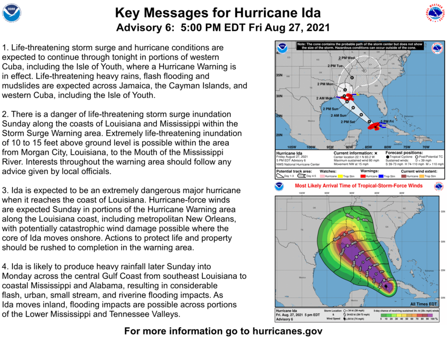
A dangerous storm surge will raise water levels by as much as 4 to 6 feet above normal tide levels in areas of onshore winds along the immediate coast of the Isle of Youth and near and to the east of where the center crosses the coast of western Cuba. Near the coast, the surge will be accompanied by large and destructive waves.
The combination of a dangerous storm surge and the tide will cause normally dry areas near the coast to be flooded by rising waters moving inland from the shoreline. The water could reach the following heights above ground somewhere in the indicated areas if the peak surge occurs at the time of high tide…

Morgan City, LA to Mouth of the Mississippi River…10-15 ft
Mouth of the Mississippi River to Ocean Springs, MS including Lake Borgne…7-11 ft
Intracoastal City, LA to Morgan City, LA including Vermilion Bay…6-9 ft
Ocean Springs, MS to MS/AL border…4-7 ft
Lake Pontchartrain…4-7 ft
Lake Maurepas…3-5 ft
Pecan Island, LA to Intracoastal City, LA…3-5 ft
MS/AL border to AL/FL border including Mobile Bay…2-4 ft
Sabine Pass to Pecan Island, LA…2-4 ft
Overtopping of local levees outside of the Hurricane and Storm Damage Risk Reduction System is possible where local inundation
values may be higher than those shown above. The deepest water will occur along the immediate coast near and to the east of the landfall location, where the surge will be accompanied by large and dangerous waves. Surge-related flooding depends on the relative timing of the surge and the tidal cycle, and can vary greatly over short distances.

