March 17
March 17, 2009
Loyce "Lois" H. Matherne
March 19, 2009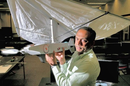
A1,500-square-foot Geospatial Technology Center containing $900,000 in new equipment opened on the first floor of the Ellender Memorial Library at Nicholls State University last month, offering a major resource to students in the university’s six-year-old program in geomatics, a blend of surveying and mapping.

Nicholls is the only university in Louisiana offering a bachelor’s degree in surveying and mapping. The geomatics program leads to certification as a professional land surveyor in the state.

The center is a regional initiative that will also be used by government agencies, said Assistant Professor of Geomatics Balaji Ramachandran.
The focal point of the center is 25 computer workstations costing around $6,000 a piece. Each computer has advanced processors and a 24-inch monitor. Four servers offer a terabyte of storage.

Surveying students have their own monitors for the first time, Ramachandran said.
The computer system cost $272,000 total and was funded by a grant from the state Board of Elementary and Secondary Education.
The center has five survey-grade and five mapping-grade, hand-held Global Positioning System units totaling $175,000. The survey grade equipment is more accurate than the mapping grade and was acquired through a loan agreement with Trimble/Navigation Electronics, Inc., Ramachandran said.
The equipment allows surveying students to more easily work on projects with real-world applications, he said. Nicholls State students can, for example, look at GPS data on emergency evacuations.

One of the center’s main attractions is a $40,000 unmanned aerial vehicle used for mapping that carries a GPS unit and a camera. The UAV’s first mission will be mapping some of Louisiana’s barrier islands after permission to fly is granted by the Federal Aviation Administration, expected in April, Ramachandran said.
Most of the UAV’s work will be concentrated on coastal areas and the center hopes eventually to obtain a larger one. Fletcher Technical Community College in Houma is collaborating with the center to operate the UAV.
The center is also equipped with two high-definition projectors costing $35,000 each funded by the university.
Since Nicholls is not connected to the Louisiana Optical Network Initiative-the fiber optic network joining several universities in the state-the center obtained $225,000 in grant money to hook into the part of the system connecting Fletcher, Tulane University and the Houma-Terrebonne Airport, Ramachandran said.
The U.S. Department of Homeland Security and the Delta Regional Authority supplied the grant money working through the South Central Planning and Development Commission.
Support was also received from the Louisiana Society of Professional Surveyors. Terrebonne Parish government contributed $90,000 and the center is hoping for support from surrounding parishes.
Ramachandran said some students from Nicholls work for Terrebonne Parish.
The center will offer short courses, user conferences and workshops for continuing education credits to help participants keep abreast of latest developments, Ramachandran said.
“The center is a combination of instruction and research,” he said. “It will be useful for south Louisiana. We want to be on the cutting edge.”
Dr. Balaji Ramachandran, assistant professor of geomatics, displays an unmanned aerial mapping vehicle – one of the features of the Geospatial Technology Center. * Photo courtesy of NSU

