Advocates: Terrebonne abuse case highlights dangers
October 28, 2014Rougarou Fest designs win creative gold award
October 28, 2014Nicholls State University’s geomatics department is setting up students for high-tech success with the use of unmanned drones.
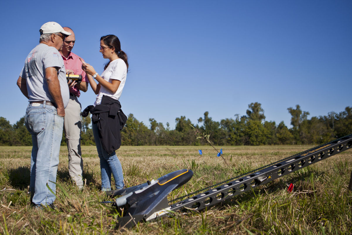
The department hosted a flying demonstration at the Nicholls Farm last week, trying out its donated Trimble UX5 air vehicle, which is capable of flying more than 16,000 feet and traveling up to 50 miles per hour.
The department had to apply for a Certificate of Authorization (COA) through the Federal Aviation Administration, which took about 60 days.
“People don’t realize that American airspace is much more complicated and congested because of crop-dusters and offshore traffic,” program head Dr. Bilaji Ramachandran said. “I have to sit with them and explain that it is purely research what we are trying to do.”
The vehicle is equipped with optical sensors for surveying and mapping. The camera is located at the bottom of the five and a half pound craft.
“As it flies over a predetermined flight path, it takes a lot of different photos. Those photos will get mosaic, stitched and panoramic,” senior Donny Rhea said. “From that, we can piece them together and make a map from it.”
The $70,000 drone was donated by Lafayette-based Navigation Electronics Inc., which also gave the university a global navigation satellite system worth $150,000.
Owner and Vice President of Sales at NEI William Poche said it is important for the company to make sure students are prepared for 21st century technology.
“One of the most important things is ensuring that the graduates of the program can get jobs when they finish. This will help that,” Poche said.
Industries have moved further away from conventional surveying, meaning they do not actually need people on foot looking at the land.
Ramachandran said experience with drones potentially prepares students for work with NASA or the U.S. Air Force.
“If we can get the knowledge of how it all works, then we can go after those jobs. There are veterans coming back from Iraq and Afghanistan who are trained in these technologies,” he said. “NASA and the U.S. Air Force put out a statement saying there are about 90 civilian applications. Now, there is a civilian sector. When it opens up, of those 90 you see about 55 of them are geared toward south Louisiana because of the offshore industry.”
Drones, or unmanned aviation vehicles (UAV, can be utilized in many different markets, especially in the Bayou State.
“For Louisiana, coastal restoration is a huge deal. We also have agriculture and understanding crops and how they differ from season to season,” Poche said. “It is definitely not an ‘if.’ It is a ‘when.’ The agriculture industry has put itself into position to be able to utilize this technology before other markets can actually have the ability to use this kind of equipment.”
Ramachandran is considering adding a hyperspectral camera to the UAV. The camera detects the difference between grass and vegetation on the ground. “That is where we should start planning so we can succeed in coastal restoration,” he said.
UAVs have also been useful in detecting toxins in the air.
“It will take air samples and figure out how bad or toxic it is without having people go out there and do that,” the program head said.
Ramachandran said the drone has helped the program. “In the past, I was teaching these courses with different exercises and explaining to them. Now I can bring them here and show them how it works.”
Volunteer pilots Joe Geist and Peter Jansen talk with Trimble UX5 trainer Alicia Llorens before sending the UAV on its flight pattern at Nicholls State University. The drone was donated to the university’s geomatics department.


