Delegation credited for combined effort
July 3, 2012
Advance Safety trained to overcome career obstacles
July 3, 2012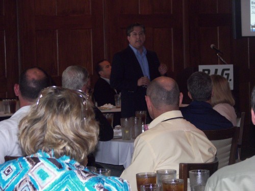
With the recent approval of the Louisiana Coastal Master Plan, Jerome “Zee” Zeringue, executive director of Coastal Protection and Restoration, explained what the authorization means to the members of the Bayou Industrial Group.

“With coastal land loss, there is a potential for $23.4 billion a year in damage ot the lives and livelihoods of this state,” Zeringue said as he showed maps of land loss going back to the 1930s. “But we have a plan. Failure [to protect our coast] is not an option.”

Since 1930, the state has lost more then 1,900 square feet of land, and, according to Zeringue, the state could potentially lose another 1,750 square feet during the next 50 years if something is not done.
“There have been changes in what is now considered the coastal zone,” said Lafourche Parish President Charlotte Randolph. “Thibodaux is now considered in the coastal zone.”

One of the many maps Zeringue showed BIG members last month was of land loss and gain over the years. Red meant land loss and green, land gain. Large patches of red far outranked the small spots of green.

“My house is here,” Zeringue said as he pointed to one of the maps. “We are currently losing 16 square miles a year, and that number could potentially climb to 51 square miles a year.”
In making his point about land formation and erosion of the area, Zeringue went back a few million years to illustrate.
“Sixty million years ago Cape Girardeau, Mo., was the coast,” Zeringue said. “Flooding of the Mississippi River is what created south Louisiana. The entire state is a deltaic plain. Five thousand years ago, New Orleans was under water.”
Zeringue’s said the Flood of 1927 offered the United States government its first view of what a deltaic plain flood could do. From there, it began to form a flood protection plan.
In addition to weather patterns that form over land, weather patterns that form over the open water can also influence coastal changes.
“A Category 2 or higher hurricane has the highest potential of making landfall on the southeast side of the state, and it’s not just hurricanes [and river movements] that cause flooding in the state,” Zeringue said.
Locally, Zeringue shifted his focus on continuing levee work to protect La. Highway 1 through Lafourche Parish.
“This road services the area that 18 to 20 percent of the country’s oil and gas resources come from,” he said. “This ribbon of roadway is important. This is a national issue that the country needs to address.”
In addition to coastal restoration jobs that are out for bids, ongoing projects include work along West Belle, the Barrier Island Headland, a Larose to Golden Meadow reach and Morganza to the Gulf. Completed projects include Timbalier Island vegetation, Bayou Lafourche vegetation and freshwater introduction into South Lake Decade.
The 2012 Coastal Master Plan, which the state legislature mandates be updated every five years using the latest technology, was formed by combining coastal conservation plans of coastal parishes and represents concepts of 400 plans and projects.
“We looked at the risk reduction and restoration of each one,” Zeringue said. “These were decision drivers. The projects land building capability projections were also looked at. We need to reduce risk to all coastal communities. Other coastal states – Texas, Mississippi and Alabama – are developing coastal plans.”
The proposed budget to carry out the master plan over the next 50 years is $20 to $50 billion. A $100 billion dollar plan was also reviewed, in the event that the federal government decided to help.
“The only thing restraining the plan is money,” Zeringue said. “We are looking at more than 40 funding options,” Zeringue said. “The 2012 plan goes a long way in identifying what needs to be a priority. This is where the rubber meets the road. The projects in the 2012 plan …outline how the Mississippi and Atchafalya rivers will play a role in stopping land loss with silt replacement. The plan is not perfect, but it is getting us closer to where we need to be. Coastal erosion is not a fix and forget problem. It is dynamic, and we have to work at it.”
Zeringue presented several scenarios on how the state plan could affect the coast, including projections that take into account variations in sea level and land building capabilities. He also showed the progression of sediment diversion of the Upper Brenton Sound at five, 25, and 50-year intervals.
“Even with the least optimistic scenarios, land would still be building up,” Zeringue said.
“There are seven proposed diversions off the Mississippi River. Some say the plan is too focused on diversion, but we are also very focused on marsh creation.”
Even with its share of naysayers, a recent survey of Louisiana voters showed that 86 percent of those polled support the 2012 master plan. By the looks of this poll, coastal restoration is on the minds of many state residents.
Jerome “Zee” Zeringue, executive director of Coastal Protection and Restoration, speaks to members of the Bayou Industrial Group. Zeringue discussed the recent approval of the Louisiana Coastal Master Plan.


