
All Catholic schools in Diocese of Houma-Thibodaux closed Monday
August 22, 2020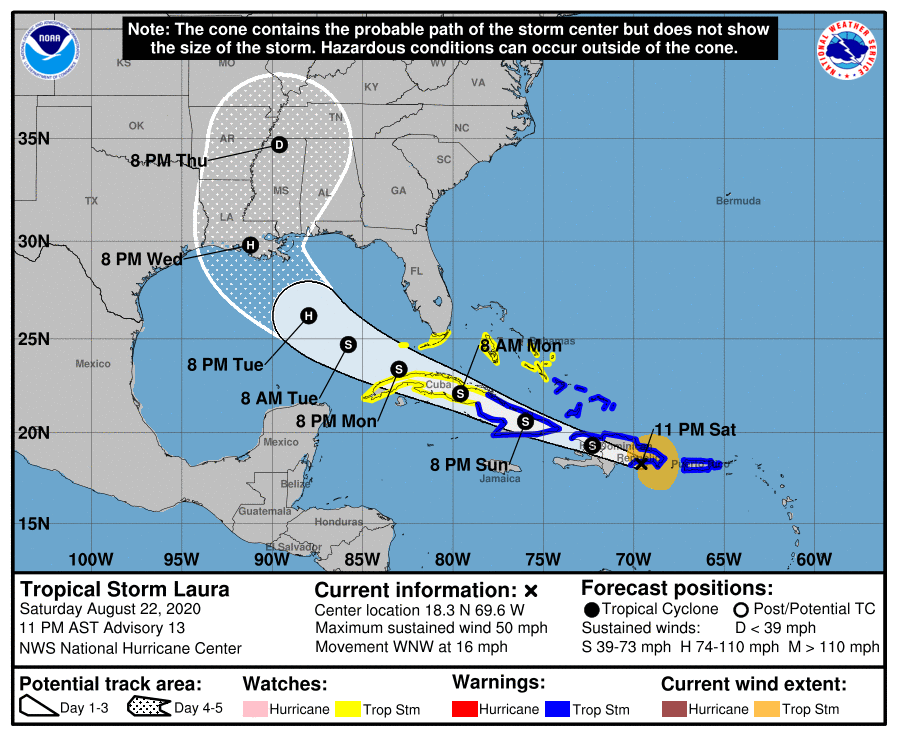
TS Laura produces heavy rains over Dominican Republic; Track continues towards Louisiana coast
August 22, 2020
Tropical Storm Marco is forecast to continue moving north-northwestward across the central Gulf of Mexico tomorrow and will approach the northern Gulf Coast on Monday. Marco is moving across deep, warm waters this evening, allowing the expected strengthening of the storm to hurricane status. As Marco approaches the Louisiana coast on Monday, it is expected to diminish.
At 1000 PM CDT (0300 UTC), the center of Tropical Storm Marco was located near latitude 22.8 North, longitude 86.3 West. Marco is moving toward the north-northwest near 13 mph (20 km/h). A gradual turn toward the west with a decrease in forward speed is expected after Marco moves inland on Monday and on Tuesday.

A Storm Surge Watch is in effect for…
* Sabine Pass to the Alabama/Florida border
* Lake Pontchartrain, Lake Maurepas, Lake Borgne, and Mobile Bay
A Hurricane Watch is in effect for…
* Intracoastal City Louisiana to the Mississippi/Alabama border
* Lake Pontchartrain, Lake Maurepas, and Metropolitan New Orleans
A Tropical Storm Watch is in effect for…
* Mississippi/Alabama border to the Alabama/Florida border

Data from an Air Force Reserve Hurricane Hunter aircraft indicate that the maximum sustained winds remain near 65 mph (100 km/h) with higher gusts. Some strengthening is anticipated and Marco is forecast to become a hurricane on Sunday. Marco is expected to be at or near hurricane strength when it approaches the northern Gulf Coast on Monday. Rapid weakening is expected after Marco moves inland.
Tropical-storm-force winds extend outward up to 70 miles (110 km) from the center.
The estimated minimum central pressure based on data from the Air Force reconnaissance plane is 994 mb (29.36 inches).

The combination of a dangerous storm surge and the tide will cause normally dry areas near the coast to be flooded by rising waters moving inland from the shoreline. The water could reach the following heights above ground somewhere in the indicated areas if the peak surge occurs at the time of high tide:
Grand Isle LA to the AL/FL Border including Lake Borgne and Mobile Bay…3-5 ft
Lake Pontchartrain and Lake Maurepas…2-4 ft
Sabine Pass to Grand Isle LA…2-4 ft
The deepest water will occur along the immediate coast in areas of onshore winds, where the surge will be accompanied by large and destructive waves. Surge-related flooding depends on the relative timing of the surge and the tidal cycle, and can vary greatly over short distances. For information specific to your area, please see products issued by your local National Weather Service forecast office.

Hurricane conditions are possible within the hurricane watch area by midday Monday, with tropical storm conditions possible by early Monday. Tropical storm conditions are possible within the tropical storm watch area on Monday.
Next intermediate advisory at 100 AM CDT. Next complete advisory at 400 AM CDT.

