
All CIS Louisiana clinics to be closed Monday
August 27, 2021
Thibodaux Police Department Office Closed due to Hurricane Ida
August 27, 2021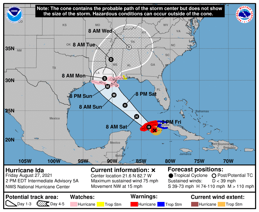
At the 1pm update, we are still looking at the potential for a very strong Category 3 storm at landfall. The center of the cone has shifted ever so slightly to the west of Terrebonne Parish, closer to St. Mary Parish.
At 200 PM EDT (1800 UTC), the center of Hurricane Ida was located by Cuban radar and Air Force Reserve Hurricane Hunter aircraft near latitude 21.6 North, longitude 82.7 West. Ida is moving toward the northwest near 15 mph (24 km/h), and this general motion should continue over the next few days. On the forecast track, the center of Ida will pass over the Isle of Youth during the next hour or so, move over western Cuba later today, and move over the southeastern and central Gulf of Mexico tonight and Saturday. Ida is forecast to make landfall along the U.S. northern Gulf coast within the hurricane watch area on Sunday.
Reports from Air Force Reserve reconnaissance aircraft indicate that the maximum sustained winds are near 75 mph (120 km/h) with
higher gusts. Additional strengthening is forecast before the center moves over western Cuba later today. Steady to rapid strengthening is expected when Ida moves over the southeastern and central Gulf of Mexico over the weekend, and Ida is expected to be a major hurricane when it approaches the northern Gulf coast.

Hurricane-force winds extend outward up to 20 miles (30 km) from the center. Tropical-storm-force winds extend outward up to 90 miles (150 km) from the center. Sustained winds of 38 mph (61 km/h) and a gust to 55 mph (89 km/h) has recently been observed on Cayo Largo, Cuba.
The latest minimum central pressure estimated from Air Force Reserve reconnaissance aircraft data is 987 mb (29.15 inches).

