Thibodaux man charged with indecent behavior with juveniles, computer-aided solicitation of a minor
August 9, 2021
Agents arrest drug dealer in South Lafourche area, police say
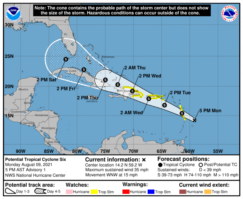
August 9, 2021The National Hurricane Center has started issuing advisories on Potential Tropical Cyclone Six. The storm is expected to reach Tropical Storm status overnight. The next name is Fred.
From NHC:
NHC is issuing advisories on Potential Tropical Cyclone Six. At 5 p.m. AST, the disturbance was centered over the Atlantic Ocean about 165 miles (260 km) east-southeast of Dominica and about205 miles (330 km) southeast of Guadeloupe. It’s moving toward the west-northwest near 15 mph (24 km/h) and this general motion is expected to continue during the next few days. On the forecast track, the system is expected to move through a portion of the southern Leeward Islands tonight, pass near or over the U.S. Virgin Islands and Puerto Rico late Tuesday and Tuesday night, and near or over Hispaniola on Wednesday.
Interests in the remainder of the Bahamas and Florida should monitor updates to the forecast for this system, but it is too soon to determine what, if any, impacts could occur there by late this week or this weekend given the uncertainty in the long-range forecast.
Maximum sustained winds are near 35 mph (55 km/h) with higher gusts. Gradual strengthening is forecast to occur during the next 48 hours and the disturbance is expected to become a tropical storm tonight. When that occurs, it will be named “Fred”.
A Tropical Storm Watch is in effect for…
* Martinique and Guadeloupe
* Dominica
* Puerto Rico, including Culebra and Vieques
* U.S. Virgin Islands
* Dominican Republic on the south coast from Punta Palenque eastward and the entire northern coast to the Dominican Republic/Haiti border.
Tropical storm conditions are possible within the watch area in the Lesser Antilles tonight, and are also possible within the watch area in the U.S. Virgin Islands and Puerto Rico beginning Tuesday afternoon. Tropical storm conditions are possible within the watch area in the Dominican Republic beginning early Wednesday.
The potential tropical cyclone is expected to produce the following rainfall amounts:
Over the Leeward Islands, Virgin Islands, and Puerto Rico…2 to 4 inches, with isolated amounts of 6 inches. This rainfall could lead to flash, urban, and small stream flooding and potential mudslides across the U.S. Virgin Islands and Puerto Rico.
The next complete advisory will be issued by NHC at 11 p.m. AST with an intermediate advisory at 8 p.m. AST


