
Huffman named NABC All-District
March 15, 2023
Lafourche Jury Convicts Attempted Carjacking Suspect
March 15, 2023
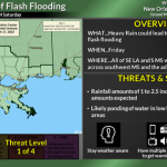
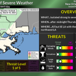
Here is an update from the National Weather Service in New Orleans concerning the severe weather and heavy rain threat Friday.
There is a MARGINAL RISK to SLIGHT RISK of Severe Weather and Heavy Rain after midnight Thursday night through Friday afternoon for all of SE Louisiana and S Mississippi.
We are confident thunderstorms will accompany a strong cold front early Friday and through much of the day. We are also confident there will be locally heavy rain and at least a few strong to marginally severe storms.
We are less confident on the exact timing. There are some indications that rain would begin around sunrise in most areas but move slower through the area. That would increase the locally heavy rain threat however a slower arrival of the cold front and rain could lead to a greater risk of severe storms.
Impacts:
The main threats associated with any severe storms will be:
Damaging Winds: Wind gusts greater than 58 mph will be possible. Trees and power lines could be damaged with the strongest storms and lead to isolated/scattered power outages
Tornadoes: A few tornadoes are possible
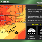
Rainfall: In addition to the severe weather threat, rainfall of 1 to 2.5 inches is forecast with locally higher amounts expected. This rainfall could lead to ponding of water in low-lying areas and areas of poor drainage.
The attached graphics highlight the threats associated with this system.

