
Several Diocese of Houma-Thibodaux schools, other private schools announce early dismissals on Jan. 8
January 7, 2024
Lafourche Chamber Foundation accepting applications for 2024 scholarships
January 8, 2024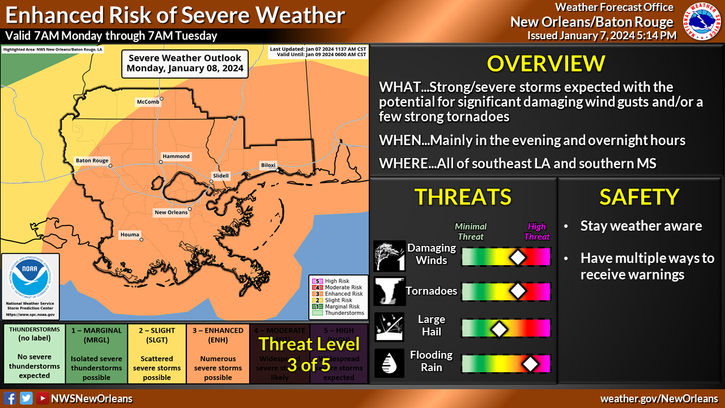
Severe Weather and Heavy Rainfall Threat for January 8, 2024
Here is an update from the National Weather Service in New Orleans concerning the severe weather and heavy rainfall threat for Monday:
Overview:
WHAT: ENHANCED RISK of Severe Weather and Heavy Rainfall
WHEN: Monday afternoon thru early Tuesday morning.
WHERE: All of SE LA and S MS.
Impacts:
The main threats associated with any severe storms will be:
Damaging Winds: Wind gusts greater than 60 mph will be possible. Trees and powerlines could be damaged and lead to isolated/scattered power outages
Tornadoes: A few tornadoes will be possible.
Hail: Large hail up to 1″ in diameter will be possible.
Rainfall:
In addition to the severe weather threat, rainfall of 2 to 3 inches is forecast with locally higher amounts possible.
This rainfall could lead to areas of flash flooding, especially where storms train over the same areas.
WIND ADVISORY: The area is under a Wind Advisory from noon Monday – 6AM CT Tuesday. Strong wind gusts wil increase during the day Monday, lasting through and after the cold front passage into Tuesday. Wind gusts can range between 45-50 MPH.
FLOOD WATCH: The area is under a Flood Watch from noon Monday – 6AM CT Tuesday.

