
2020 Louisiana Gumbo Festival canceled
September 12, 2020
Local, state and federal officials discuss bringing oil and gas jobs back to Louisiana
September 12, 2020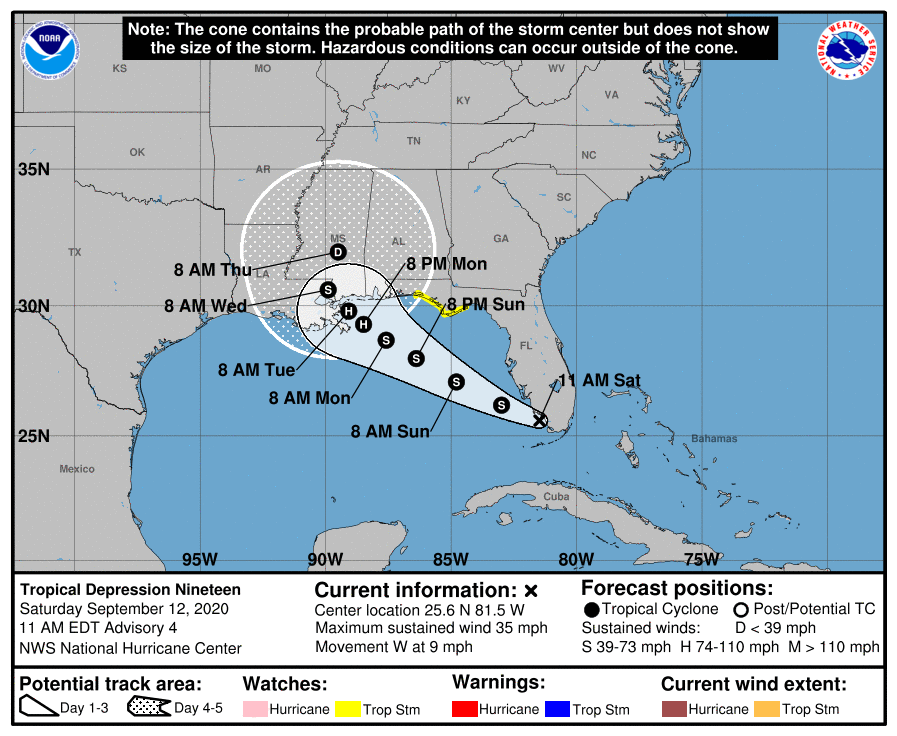
Louisiana is closely monitoring Tropical Depression 19, which is forecast to become a category 1 hurricane before landfall Tuesday Morning. Our area needs to be prepared for a possible tropical storm or hurricane affecting the coastline of Terrebonne and Lafourche parishes.
At 11 a.m. EDT, the center of Tropical Depression Nineteen was located inland over South Florida about 40 miles (65 km) south-southeast of Naples. The depression is moving toward the west near 9 mph (15 km/h), and a turn toward the west-northwest is expected later today. A west-northwestward or northwestward motion with a decrease in forward speed is then expected during the next couple of days. On the forecast track, the center is forecast to move over the southeastern and eastern Gulf of Mexico later today and Sunday, and then move over the north-central Gulf of Mexico Sunday night and
Monday.
Maximum sustained winds are near 35 mph (55 km/h) with higher gusts. Strengthening is expected when the center moves over the Gulf of Mexico, and the depression is expected to become a tropical storm later today or tonight, and continue to intensify Sunday and Monday. The system is forecast to become a hurricane by late Monday.

Tropical Depression Nineteen is expected to produce total rainfall of 3 to 6 inches with isolated 8 inch amounts over the Florida Keys through tonight with 2 to 4 inches and isolated maximum amounts of 6 inches across southern Florida and the western Florida coast to the Tampa Bay metro area. This rainfall will produce flash and urban flooding across southern Florida and prolong high flows and ongoing minor flooding on rivers across Central Florida. It’s then expected to produce through Tuesday rainfall of 3 to 6 inches with localized amounts of 8 inches along the Gulf Coast from the Florida Peninsula to southeast Louisiana Sunday and 2 to 4 inches farther inland over far southern Alabama, Mississippi and southeast Louisiana. This is expected to be a slow-moving system that will likely continue to produce heavy rainfall and considerable flooding near the central Gulf Coast through the middle of next week. Flash, urban and rapid onset flooding along small streams and minor to isolated moderate flooding on rivers is likely.
The next complete advisory will be issued by NHC at 5 p.m. EDT with an intermediate advisory at 2 p.m. EDT

