LDH: Hospitalizations continue to decline
August 26, 2021
TPCG Commends Response to August Shooting Near St. Francis
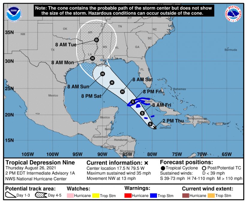
August 26, 2021Tropical Depression 9 is forecast to approach the Gulf coast on Sunday, possibly as a major hurricane (considered category 3 or above). National Hurricane Center shows landfall as a 110mph Category 2 hurricane near Morgan City, Louisiana. Now is the time to make sure you have the hurricane safety kit & supplies, fill up car with gas, review your hurricane safety plan, just in case.
From NHC:
At 2 p.m. EDT, the center of Tropical Depression Nine was located over the west-central Caribbean Sea about 165 miles (270 km) southeast of Grand Cayman and about 95 miles (155 km) southwest of Negril, Jamaica. The depression is moving toward the northwest near 13 mph (20 km/h), and this general motion should continue over the next few days. On the forecast track, the center of the depression will pass near or over the Cayman Islands tonight, the Isle of Youth and western Cuba Friday, and over the southeastern and central Gulf of Mexico Friday night and Saturday. The system is forecast to approach the U.S. northern Gulf coast on Sunday.
Maximum sustained winds are near 35 mph (55 km/h) with higher gusts. The estimated minimum central pressure is 1005 mb (29.68 inches). Steady strengthening is forecast during the next few days. The depression is expected to become a tropical storm tonight (the next name on the Atlantic name list is “Ida”) and become a hurricane when it is near western Cuba or over the southeastern Gulf of Mexico. Additional strengthening is likely over the Gulf of Mexico, and the system could be near major hurricane strength when it approaches the northern Gulf coast.
A dangerous storm surge will raise water levels by as much as 2 to 4 feet above normal tide levels in areas of onshore flow along the immediate coast of the Isle of Youth and near and to the east of where the center crosses the coast of western Cuba. Near the coast, the surge will be accompanied by large and destructive waves.
The depression is expected to produce total rainfall accumulations of 6 to 10 inches with maximum totals of 15 inches across Jamaica. Rainfall totals of 8 to 12 inches with isolated maximum amounts of 20 inches are expected across the Cayman Islands, western Cuba, including the Isle of Youth and the northeast portions of the Yucatan Peninsula. These rainfall amounts may produce life-threatening flash floods and mudslides. Rainfall from this system is likely to begin impacting portions of the central U.S. Gulf Coast by early Sunday.
The next advisory will be issued by NHC at 5 p.m. EDT –


