
Sheriff Webre Launches Comprehensive Effort to Battle Opioid Addictions in Lafourche Parish
June 1, 2023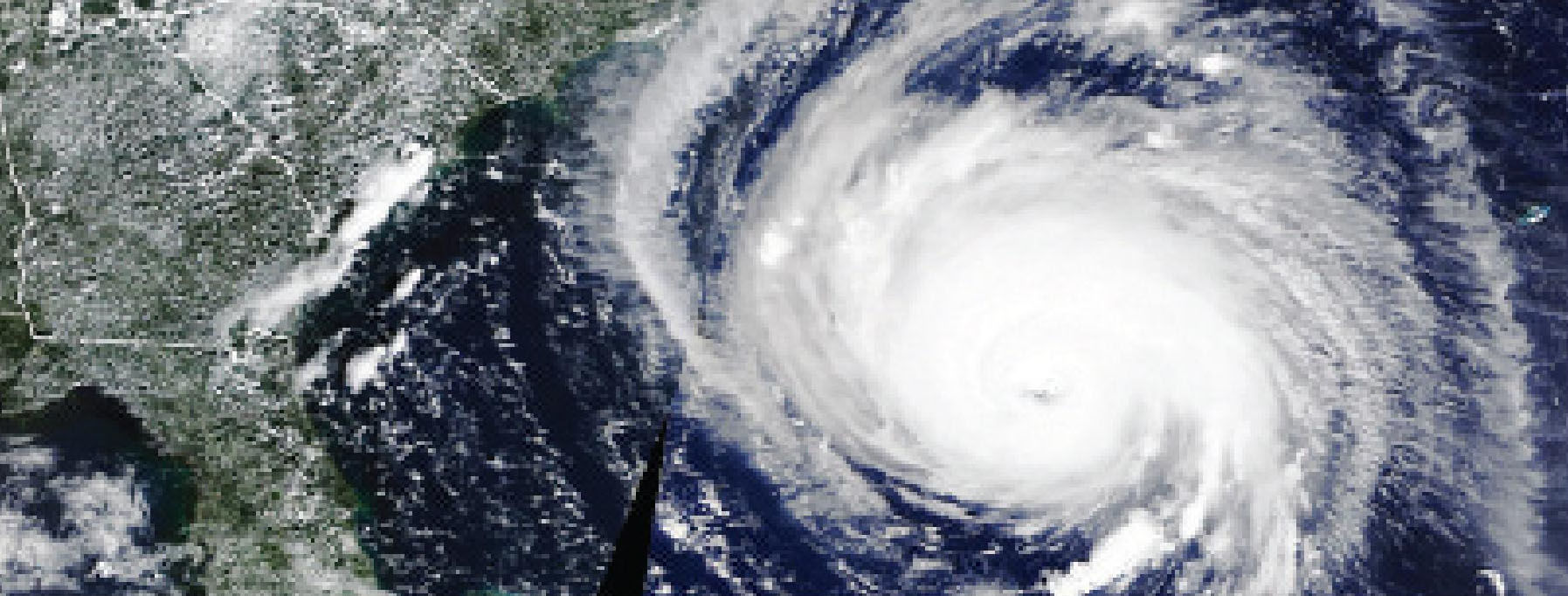
CSU researchers increase forecast, now predict near-average 2023 Atlantic hurricane season
June 1, 2023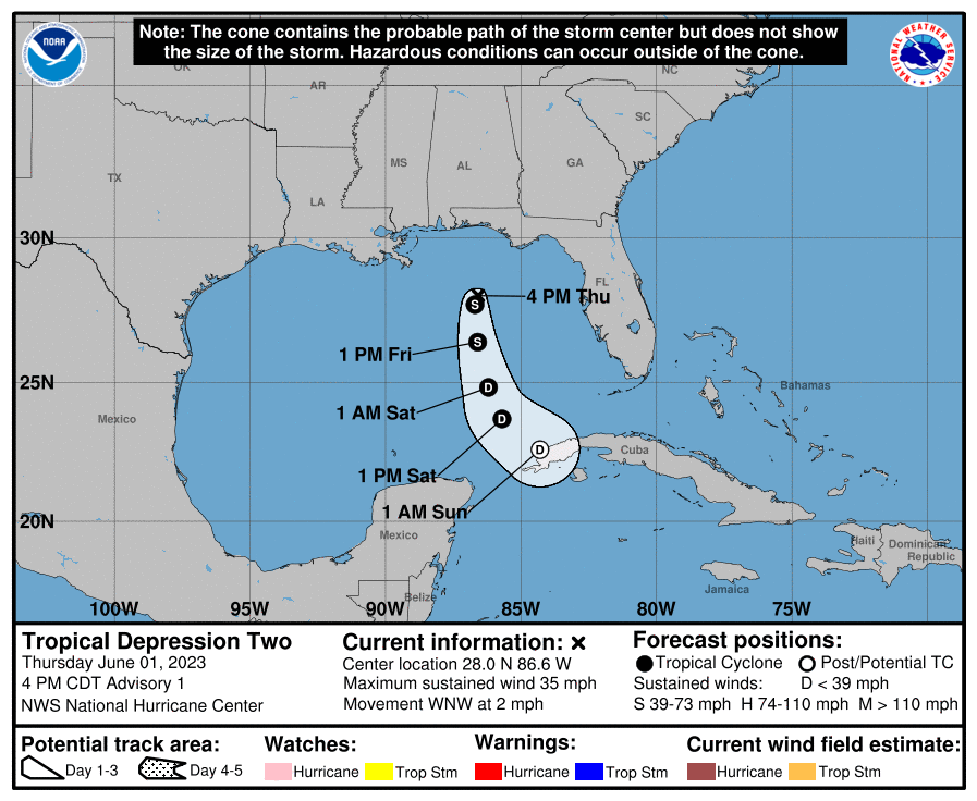
Satellite imagery over the past 12-18 hours indicate that the area of low pressure in the northeastern Gulf of Mexico has become better organized. A burst of moderate to deep convection that initiated last night has persisted into the afternoon with an increase in banding, though the cloud tops have been warming recently. An earlier ASCAT-C pass at 1558 UTC also indicated a broad closed circulation had developed along the southern edge of the cirrus canopy. The NOAA ship Ronald H. Brown passed very near the center earlier, showing a distinct wind shift with west-southwest winds just south of the center. An Air Force Reserve Reconnaissance aircraft has been investigating the system this afternoon. So far, the aircraft was able to close off a circulation, and found flight level winds in the 35-40 kt range to the northeast of the center. The most recent TAFB Dvorak fix provided a data-T number of 2.0/30-kt. Based on all the above data, the system has enough organization to initiate advisories on Tropical Depression Two, with maximum sustained winds of 30 kt.

The depression has been meandering today, with the estimated motion at 290/2 kt. Currently, the steering currents over the system are light and variable as the cyclone is positioned directly overhead of an upper-level trough. However as this trough shifts eastward, deep-layer flow out of the north-northwest should begin to move the cyclone slowly to the south or south-southwest with gradually increasing forward motion. The initial NHC forecast track has
elected to stay close to the reliable consensus aid TVCN, which is pretty close to a blend of the latest GFS and ECMWF forecasts.
Intensity-wise, there is a small window for the system to intensify further over the next 12-24 hours. While SHIPS diagnosed 200-850 mb westerly shear is quite high, above 30 kt, with plenty of dry mid-level air lurking to the west, the GOES-16 derived motion winds suggest the cold cloud tops only extend up to 300 mb where westerly flow is currently lighter. This factor may explain why upper-level cirrus outflow has been expanding westward away from the center in the northern semicircle. Sea surface temperatures between 26-27 C combined with cold upper-level temperatures are also likely helping to maintain enough thermodynamic instability for moderate to deep convection to persist near the center. For this reason, the latest NHC intensity forecast shows some modest intensification over the next 12-24 h. However, by Friday night into Saturday, the same northwesterly flow steering the system is also expected to rapidly increase the shear as the system becomes positioned on the upstream side of the upper-level trough, where subsidence may inhibit additional convection. Thus, weakening is forecast to begin by Friday night and the latest forecast degenerates the cyclone into a remnant low by 60-h with dissipation shortly thereafter.
At this juncture, the relatively small wind field of the tropical cyclone, combined with its motion keeping the center over the open Gulf of Mexico for at least the next few days precludes the need for any Watches and Warnings at this time.

Per the Public Information Statement that was issued by NHC on May 11, this system is being numbered as the second cyclone of 2023 in the Atlantic basin and is being designated as Tropical Depression Two. During the course of typical re-assessment of weather systems in the NHC’s area of responsibility, NHC determined that an area of low pressure that formed off the northeastern coast of the United States in mid-January was an “unnamed” subtropical cyclone and was given AL012023 as its system ID. As a result, this system is designated as AL022023, and advisories are being issued in AWIPS bin 2 (e.g., Public Advisories have been issued under AWIPS header TCPAT2 and WMO header WTNT32 KNHC).
If Tropical Depression Two becomes a tropical storm, it would be given the name `ARLENE`.

